1970s Maps of Washington Parish, Louisiana
Explore 16 historic maps of Washington Parish from the 1970s. These maps offer a rare glimpse into what life looked like during the 1970s — showing old roads, neighborhoods, homes, and landmarks that have changed or disappeared over time.
Whether you're researching your family's past, planning a metal detecting trip, or studying how Washington Parish's landscape evolved across the 1970s, these high-resolution maps are a powerful tool for exploring the history of this region.
- Focus on a specific era: All maps on this page are from the 1970s, giving you a focused view of this time period.
- See what’s changed: Compare century-old streets, trails, and buildings to today's modern landscape using overlays and satellite layers.
- Research with precision: Use these maps for genealogy, historical research, land use analysis, or educational projects.
- View, download, or print: Maps are fully viewable online in high resolution, and can be downloaded or printed for your own records.
Start exploring Washington Parish's history through authentic maps from the 1970s. This is your window into the past.
Washington Parish, LA maps
(16)- 1970 Map of Tylertown SE, 1972 Print
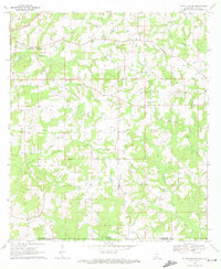 1970 Tylertown SE1972 Print · USGSThe Mississippi-Louisiana border comes into focus in the early seventies, capturing a rural landscape of creek-side settlements and family cemeteries. Genealogists can trace local roots through landmarks like Ard Cem, New Zion Ch, and the small community of Flowers.2 unique versions available
 - 1970 Map of Dexter, 1972 Print
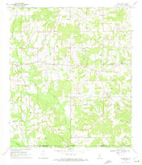 1970 Dexter1972 Print · USGSWalthall County, Mississippi, and Washington Parish, Louisiana, meet in this early 1970s survey of a landscape shaped by petroleum and timber. Genealogists and researchers can locate family sites like Fortenberry Cem and old rural churches such as Centerville Ch and Mt Olive Ch.
 - 1970 Map of Tylertown, 1972 Print
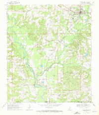 1970 Tylertown1972 Print · USGSWalthall County and Washington Parish at the turn of the 1970s show a landscape shaped by the Bogue Chitto river and the Gulf Mobile and Ohio railroad. Local historians can trace family roots through numerous sites like Brock Cem, Lexie, and New Bethel Ch.
 - 1970 Map of Sandy Hook, 1972 Print
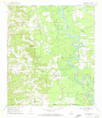 1970 Sandy Hook1972 Print · USGSThe Pearl River floodplain at the Mississippi-Louisiana border was a landscape of winding oxbows and rural rail lines during the 1970s. Genealogists can trace family names through numerous burial grounds like Warren Cem and Capp Cem, or locate landmarks such as Sandy Hook and the Gulf Mobile and Ohio railroad.2 unique versions available
 - 1972 Map of Progress, 1975 Print
 1972 Progress1975 Print · USGSSouthern Mississippi at the turn of the 1970s reveals a landscape of family farms and creek-side settlements. Genealogists can locate family landmarks like Brumfield Cem and Walker Cem or the Bala Chitto Ch near the Louisiana state line.2 unique versions available
 - 1974 Map of Hammond, 1977 Print
 1974 Hammond1977 Print · USGSTangipahoa Parish in the mid-1970s shows a landscape of growing towns and deep-rooted rural communities. Trace family history at Wainwright Cem or Shady Grove Ch, and explore the rail corridor through Independence and Natalbany.
 - 1974 Map of Husser, 1977 Print
 1974 Husser1977 Print · USGSTangipahoa Parish in the mid-seventies shows a landscape of timber stands and quiet rural settlements. Genealogists can trace family landmarks like Wainwright Cem and Olliphant Cem, or locate the Loranger Lookout Tower and Baldwin Chapel.2 unique versions available
 - 1976 Map of Folsom NE, 1977 Print
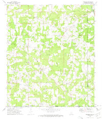
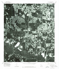
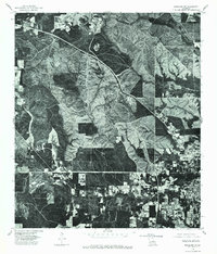
 1976 Folsom NE1977 Print · USGSThe rural timberlands and river bottoms of Washington Parish are captured here in the mid-1970s just as land-use patterns were shifting. You can trace the small community of Enon and the dramatic meanders of the Bogue and Chitto river system.
 - 1976 Map of Bogalusa NE, 1977 Print
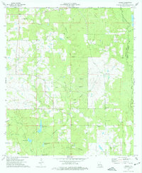
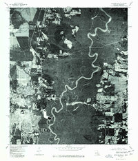
 1976 Bogalusa NE1977 Print · USGSThe timberlands and river bottoms of Washington Parish are captured here in the mid-1970s. Local researchers can trace the rural landscape between Angie and Varnado, including the deep oxbows along the Pearl River.
 - 1976 Map of Sun NW, 1977 Print
 1976 Sun NW1977 Print · USGSWashington Parish in the mid-seventies is documented here through high-resolution aerial photography of the rural pine woods and bottomlands. Researchers can trace property lines and roads around SUN and RIO or follow the path of Lees Creek as it winds through the timber.
 - 1976 Map of Bogalusa SE, 1977 Print
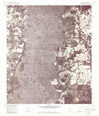
 1976 Bogalusa SE1977 Print · USGSThe industrial edge of Bogalusa and the dense swamp forests of the Mississippi border are shown here during the mid-seventies. Researchers can trace the development of Bogalusa and the dramatic, twisting course of the Pearl River.
 - 1976 Map of Sun NE, 1977 Print
 1976 Sun NE1977 Print · USGSThe borderlands between Mississippi and Louisiana appear in sharp detail in the mid-1970s. Trace the winding course of the Pearl River and the rural roads near Henleyfield and Lees Creek.
 - 1976 Map of Franklinton SE, 1977 Print
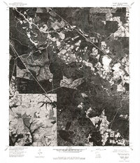
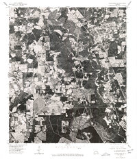
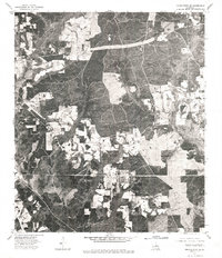 1976 Franklinton SE1977 Print · USGSWashington Parish in the mid-seventies is revealed through direct aerial imagery in this specialized orthophotomap. Researchers can examine the physical layout of the Sheridan settlement and trace the exact footprint of forest clearings and rural homesteads.
 - 1976 Map of Folsom NW, 1977 Print
 1976 Folsom NW1977 Print · USGSThe rural landscape north of Folsom is captured in sharp detail by this mid-1970s orthophoto. Local researchers can trace old road alignments and the footprint of the Folsom settlement amidst a mosaic of timberland and early agricultural clearings.
 - 1976 Map of Bogalusa SW, 1977 Print
 1976 Bogalusa SW1977 Print · USGSThe timber country and northern fringes of the paper-mill town appear in sharp detail just after the mid-seventies. Local historians can trace the expanding residential footprint and industrial layout around Bogalusa through this precise photographic survey.
 - 1976 Map of Franklinton SW, 1977 Print
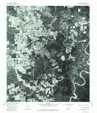
 1976 Franklinton SW1977 Print · USGSWashington Parish at the height of the 1970s is captured here through detailed aerial photography, showing the town of Franklinton and the surrounding river bottomlands. Researchers can trace the winding course of the Bogue Chitto and examine the clear-cut edges of rural homesteads and timber operations.
End of results
Showing maps 1-16 of 16
Top cities of Washington Parish
Frequently asked questions
- What are the different types of historical maps available for Washington Parish?
- What is the oldest map of Washington Parish?
- Where can I purchase historical maps of Washington Parish for my home or office?
- Where can I download high-res historical maps of Washington Parish?
- Are there historical topographic maps available for Washington Parish?
- Is there historical aerial imagery available for Washington Parish?
- Where are historical maps of Washington Parish sourced from?