Old Maps of T42 MD BPP, Maine for Academic Research
Study the evolution of T42 MD BPP with 43 high-resolution historic maps. Whether you're teaching, researching, or modeling changes in land use, these maps provide essential visual documentation of urban, environmental, and geographic change.
- Analyze long-term change: Track patterns in development, transportation, and natural features.
- Ideal for environmental or urban studies: Support academic projects with primary historical map data.
- Use in the classroom or lab: Educators and researchers rely on these maps to bring historical context to life.
These maps are a powerful tool for teaching, research, and visualizing how T42 MD BPP has changed over the decades.
T42 MD BPP, ME maps
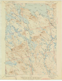
(43)- 1932 Map of Nicatous Lake
 1932 Nicatous Lake1932 Print · USGSNicatous Lake and the surrounding Maine wilderness are captured here in the early 1930s, when private sporting retreats and seasonal camps dotted the shoreline. Genealogists and local historians can trace specific locations like the Explorers Club, Adler Tavern Camp, and Sullivan Camp.4 unique versions available
 - 1934 Map of Nicatous Lake
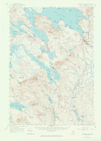
 1934 Nicatous Lake1934 Print · USGSHancock County was a landscape of remote sporting camps and timber trails in the early 1930s. Genealogists and historians can trace old sites like Poplar Tavern Camp, the Nicatous Club, and No 2 Camp set among landmarks like Duck Mtn.4 unique versions available
 - 1941 Map of Wabassus Lake, 1962 Print
 1941 Wabassus Lake1962 Print · USGSThe Downeast timberlands of Washington County were a labyrinth of logging camps and glacial lakes just before the mid-century. Researchers can trace the water-and-woods economy through Farm Cove Dam, the Dennison Portage, and the village of Grand Lake Stream.
 - 1943 Map of Wabassus Lake
 1943 Wabassus Lake1943 Print · USGSThe Maine wilderness of Washington County comes alive in the 1940s through its intricate network of lakes, logging camps, and traditional portages. Local historians can trace the foundations of Grand Lake Stream or locate remote sites like The Birches and Holland Camp.3 unique versions available
 - 1953 Map of Wabassus Lake, 1984 Print
 1953 Wabassus Lake1984 Print · USGSMaine's wilderness townships come to life in this mid-century survey of the interconnected waterways north of the Machias River. Researchers can trace historic forest service landmarks like the State Forest Service Camp or locate the village of Grand Lake Stream and its local cemetery.
 - 1954 Map of Millinocket, 1968 Print
 1954 Millinocket1968 Print · USGSMaine's North Woods and the Penobscot Valley are captured here during the mid-century era of logging and rail dominance. You can trace the path of the Bangor and Aroostook Railroad through timber towns like Millinocket, Mattawamkeag, and Silver Ridge.3 unique versions available
 - 1957 Map of Fredericton, 1981 Print
 1957 Fredericton1981 Print · USGSThe New Brunswick and Maine borderlands come into focus in the mid-fifties, dominated by the Saint John River and massive military tracts. Genealogists can locate riverfront hamlets like Maugerville or inland sites like Scotch Settlement along the Canadian Pacific rail line.
 - 1958 Map of Millinocket
 1958 Millinocket1958 Print · USGSMaine's North Woods and the Penobscot river valley are captured here in the mid-1950s, showing a landscape of timber, rail, and wild waters. Researchers can trace the legacy of the Canadian Pacific railroad and find historic settlements like Millinocket, Sherman Station, and Mattawamkeag.
 - 1960 Map of Millinocket
 1960 Millinocket1960 Print · USGSThe Maine North Woods and Penobscot River valley are captured at mid-century during the height of the paper milling era. Researchers can trace the Appalachian Trail near Mount Katardin or locate family roots in towns like Dover-Foxcroft and Milo.3 unique versions available
 - 1963 Map of Fredericton
 1963 Fredericton1963 Print · USGSThe Saint John River valley and the Maine-New Brunswick border are captured here during the early sixties. Researchers can trace the Canadian Pacific rail lines through rural settlements like Jewetts Mills, Mckeens Corner, and Scotch Settlement.
 - 1963 Map of Wabassus Lake, 1966 Print
 1963 Wabassus Lake1966 Print · USGSThe interconnected lakes and forest camps of eastern Maine are captured here in the mid-1960s. Researchers can trace historical portages and remote outposts like Elsemore Landing, the State Forest Service Camp, and Grand Lake Stream.2 unique versions available
 - 1975 Map of Nicatous Lake SE, 1980 Print
 1975 Nicatous Lake SE1980 Print · USGSThe timberlands and glacial waters of Hancock County come into focus in the mid-1970s. Trace the logging roads through the forest and locate landmarks like Sabao Mountain in this detailed aerial orthophoto.
 - 1975 Map of Nicatous Lake NE, 1980 Print
 1975 Nicatous Lake NE1980 Print · USGSThe interior of Hancock County is captured in this mid-seventies aerial survey, showing the deep woods of eastern Maine. Researchers can examine the shoreline and surrounding timber around Duck Lake to see the landscape as it stood before modern development.
 - 1975 Map of Wabassus Lake SW, 1980 Print
 1975 Wabassus Lake SW1980 Print · USGSWashington County's timberlands are seen in detail during the mid-seventies through this aerial orthophotoquad. Researchers can trace the untouched terrain surrounding Fletcher Peak, Bald Mountain, and the quiet slopes of Knox Mountain.
 - 1975 Map of Wabassus Lake NW, 1980 Print
 1975 Wabassus Lake NW1980 Print · USGSThe Maine North Woods and the jagged eastern shores of West Grand Lake are captured here in the mid-seventies. Researchers can trace forest management patterns and lake topography near the heights of Dark Cove Mountain.
 - 1985 Map of Lincoln, 1994 Print
 1985 Lincoln1994 Print · USGSPenobscot County in the mid-eighties remains a landscape of river-based commerce and sprawling timberlands connected by rail. You can trace the historic paths of the Maine Central RR and Canadian Pacific RR or locate rural sites like Enfield Station and the Winn Cem.
 - 1986 Map of Calais
 1986 Calais1986 Print · USGSCoastal and interior Washington County are captured here in the mid-1980s, where the international border follows the winding St Croix River. Genealogists and historians can trace the rail lines of the Maine Central and find landmarks like Red Beach and Princeton Airport.
 - 1986 Map of Lincoln
 1986 Lincoln1986 Print · USGSMid-century Maine settlement and industry converge along the Penobscot and Piscataquis rivers during the 1980s. Researchers can trace the rail networks of the Maine Central and Bangor and Aroostook through towns like Howland and Milo.
 - 1987 Map of Duck Lake, 1988 Print
 1987 Duck Lake1988 Print · USGSThe Maine woods at the edge of Washington County in the 1980s are defined by a complex labyrinth of interconnected waterways and timberlands. Trace the remote drainages of Duck Lake and Sysladobsis Lake, or locate family landmarks near Lakeville and Duck Mtn.
 - 1987 Map of Gassabias Lake, 1988 Print
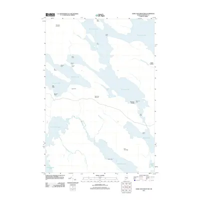
 1987 Gassabias Lake1988 Print · USGSThe unorganized territories of Hancock and Washington counties are documented here in the late 1980s, showing a vast Maine timberland before significant modern change. Trace the primitive roads and water routes connecting Gassabias Lake, Upper Sabao Lake, and Sabao Mountain.
 - 1990 Map of Dark Cove Mountain
 1990 Dark Cove Mountain1990 Print · USGSThe interconnected lakes of Washington County are shown in great detail during the late twentieth century, before the digital age reshaped backcountry navigation. Trace historical water routes and portages including Dennison Portage, Dobsis Dam, and the landing at Elsemore Landing.
 - 1990 Map of Fletcher Peak
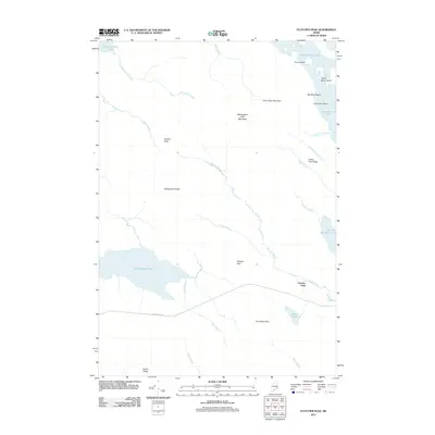
 1990 Fletcher Peak1990 Print · USGSWashington County’s interior lake country is shown in the early nineties, characterized by high timbered peaks and isolated waters. Researchers can trace land divisions and landmark elevations like Fletcher Peak, the Lookout Tower, and Third Machias Lake.
 - 1994 Map of Calais
 1994 Calais1994 Print · USGSEastern Maine's river and lake country comes into focus in the 1990s, centered on the international border at Calais and the vast Passamaquoddy Indian Reservation. Researchers can trace the water-linked settlements of Grand Lake Stream, the airfield at Princeton Airport, and the industrial heritage of Woodland.
 - 2011 Map of Dark Cove Mountain, 2011 Print
 2011 Dark Cove Mountain2011 Print · USGSCovers T42 MD BPP, including Sakom Township, T43 MD BPP, and other nearby areas
 - 2011 Map of Fletcher Peak, 2011 Print
 2011 Fletcher Peak2011 Print · USGSCovers T42 MD BPP, including T36 MD BPP, T35 MD BPP, and other nearby areas
Showing maps 1-25 of 43
Top cities near T42 MD BPP
- Grand Lake Stream historical maps
- Lakeville historical maps
- Talmadge historical maps
- Pukakon Township historical maps
Frequently asked questions
- What are the different types of historical maps available for T42 MD BPP?
- What is the oldest map of T42 MD BPP?
- Where can I purchase historical maps of T42 MD BPP for my home or office?
- Where can I download high-res historical maps of T42 MD BPP?
- Are there historical topographic maps available for T42 MD BPP?
- Is there historical aerial imagery available for T42 MD BPP?
- Where are historical maps of T42 MD BPP sourced from?