1940s Maps of Marshall County, Minnesota
Explore 4 historic maps of Marshall County from the 1940s. These maps offer a rare glimpse into what life looked like during the 1940s — showing old roads, neighborhoods, homes, and landmarks that have changed or disappeared over time.
Whether you're researching your family's past, planning a metal detecting trip, or studying how Marshall County's landscape evolved across the 1940s, these high-resolution maps are a powerful tool for exploring the history of this region.
- Focus on a specific era: All maps on this page are from the 1940s, giving you a focused view of this time period.
- See what’s changed: Compare century-old streets, trails, and buildings to today's modern landscape using overlays and satellite layers.
- Research with precision: Use these maps for genealogy, historical research, land use analysis, or educational projects.
- View, download, or print: Maps are fully viewable online in high resolution, and can be downloaded or printed for your own records.
Start exploring Marshall County's history through authentic maps from the 1940s. This is your window into the past.
Marshall County, MN maps
(4)- 1941 Map of Kennedy
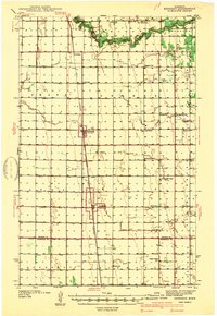 1941 Kennedy1941 Print · USGSNorthwest Minnesota farming life is centered on the rail corridor during the late 1930s. Genealogists and historians can trace the foundations of rural society through landmarks like West Emmaus Ch, Happy Corner, and the Whalen Sch.
 - 1941 Map of Drayton
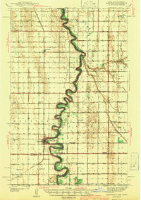 1941 Drayton1941 Print · USGSThe Red River of the North snakes across the border of North Dakota and Minnesota during the late 1930s. Genealogists and historians can trace rail-side towns like Bowesmont and Drayton, or locate rural landmarks such as Skjeberg Ch and the Airway Beacon.2 unique versions available
 - 1943 Map of Rollis
 1943 Rollis1943 Print · USGSMarshall County's rural townships are documented here during the first half of the twentieth century, showing a landscape defined by drainage engineering and early settlement. Researchers can trace family roots through numerous schools and churches or locate original township sites like Gatzke, Jonstad, and the Old Indian Reservation Boundary Line.
 - 1943 Map of Thief River Falls
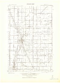 1943 Thief River Falls1943 Print · USGSPennington County during the Second World War shows a landscape defined by the convergence of major rail lines and the drainage of the Red River Valley. Genealogists and historians can trace rail stops and rural landmarks like Steiner, St. Hilaire, and Church Cem.
End of results
Showing maps 1-4 of 4
Top cities of Marshall County
- Warren historical maps
- Stephen historical maps
- Argyle historical maps
- Alvarado historical maps
- Newfolden historical maps
- Oslo historical maps
See more
Frequently asked questions
- What are the different types of historical maps available for Marshall County?
- What is the oldest map of Marshall County?
- Where can I purchase historical maps of Marshall County for my home or office?
- Where can I download high-res historical maps of Marshall County?
- Are there historical topographic maps available for Marshall County?
- Is there historical aerial imagery available for Marshall County?
- Where are historical maps of Marshall County sourced from?