1960s Maps of Marshall County, Minnesota
Explore 25 historic maps of Marshall County from the 1960s. These maps offer a rare glimpse into what life looked like during the 1960s — showing old roads, neighborhoods, homes, and landmarks that have changed or disappeared over time.
Whether you're researching your family's past, planning a metal detecting trip, or studying how Marshall County's landscape evolved across the 1960s, these high-resolution maps are a powerful tool for exploring the history of this region.
- Focus on a specific era: All maps on this page are from the 1960s, giving you a focused view of this time period.
- See what’s changed: Compare century-old streets, trails, and buildings to today's modern landscape using overlays and satellite layers.
- Research with precision: Use these maps for genealogy, historical research, land use analysis, or educational projects.
- View, download, or print: Maps are fully viewable online in high resolution, and can be downloaded or printed for your own records.
Start exploring Marshall County's history through authentic maps from the 1960s. This is your window into the past.
Marshall County, MN maps
(25)- 1960 Map of Big Woods NW, 1961 Print
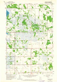
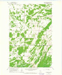
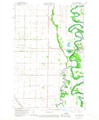
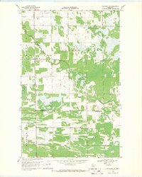
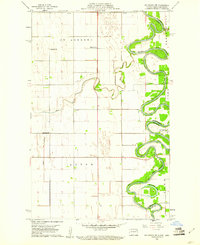 1960 Big Woods NW1961 Print · USGSThe Red River Valley at the turn of the 1960s reveals a sparse but structured landscape of township schools and river crossings. Researchers can trace the boundaries of St Andrews and Acton, locating rural landmarks like St Joseph Ch and Zion Cem.2 unique versions available
 - 1961 Map of Radium, 1963 Print
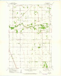
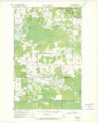
 1961 Radium1963 Print · USGSMarshall County's prairie landscape in the early sixties is defined by remote townships and the essential route of the SOO LINE railroad. Family historians can trace local roots at Immanuel Cem and the Townhall near the winding Snake River.2 unique versions available
 - 1961 Map of Thief River Falls NE, 1963 Print
 1961 Thief River Falls NE1963 Print · USGSThe northern Minnesota borderlands between Marshall and Pennington Counties appear here as a land of managed waters and rural parish life in the early 1960s. Family historians can locate several landmarks like Satersdal Cem, Sunnyside Sch, and Bethlehem Ch.2 unique versions available
 - 1961 Map of Middle River NE, 1963 Print
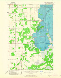
 1961 Middle River NE1963 Print · USGSMarshall County's rural landscape is captured here in the early sixties, showing the vital intersection of agriculture and conservation. Genealogists and local historians can locate the Riverside Cem and Evangelical Cem or trace the early boundaries of the Agassiz National Wildlife Refuge.2 unique versions available
 - 1961 Map of Thief River Falls NW, 1963 Print
 1961 Thief River Falls NW1963 Print · USGSThe rail-and-river hub of northwest Minnesota comes alive in the early sixties as the city expands toward the north and west. Researchers can trace family sites near St Bernard Cem, follow the Great Northern tracks to Dakota Junction, and locate the Steiner Community Hall.2 unique versions available
 - 1961 Map of Middle River SE, 1963 Print
 1961 Middle River SE1963 Print · USGSManaged wetlands and prairie townships of Marshall County come into focus during the early sixties. Researchers can trace the Indian Treaty Boundary and explore the vast water levels of Northwest Pool and Green Stump Pool.
 - 1961 Map of Roan, 1963 Print
 1961 Roan1963 Print · USGSSettled along the Great Northern railway in the 1960s, this area of Marshall and Polk counties shows a landscape of river meanders and rail lines. You can trace the Soo Line tracks, locate the Roan station, and find mid-century infrastructure like the Warren Airport.2 unique versions available
 - 1962 Map of Strathcona, 1964 Print
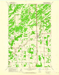
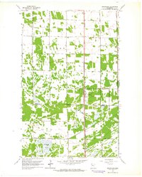 1962 Strathcona1964 Print · USGSStrathcona and the surrounding townships of Deer and Huntly are shown in the early 1960s, centered on the corridor of the Great Northern railway. Trace local family history through the locations of Bethlehem Cem, Poplar Grove Ch, and the rural Townhall.2 unique versions available
 - 1962 Map of Gatzke NW, 1964 Print
 1962 Gatzke NW1964 Print · USGSMarshall County in the early sixties was a landscape defined by expansive conservation efforts and historic borders. Trace the Old Indian Treaty Boundary and locate family landmarks like Our Savior Ch and the Refuge Headquarters.2 unique versions available
 - 1962 Map of Gatzke SE, 1964 Print
 1962 Gatzke SE1964 Print · USGSMarshall County's sprawling wetlands and prairie transitions are preserved here in the early sixties, showing a landscape dedicated to conservation. Genealogists and historians can trace the bounds of Rollis and Moylan across the Agassiz National Wildlife Refuge and Mud River.2 unique versions available
 - 1962 Map of Middle River, 1964 Print
 1962 Middle River1964 Print · USGSThe Great Northern railway corridor defines this Marshall County landscape in the early sixties. Genealogists can trace family footprints at Gaarde Cem, Spruce Valley Cem, and Finnish Lutheran Cem, or locate the civic center at the Townhall.
 - 1962 Map of Gatzke SW, 1964 Print
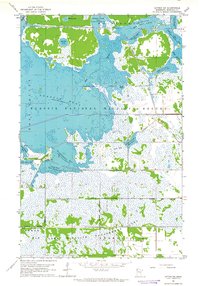 1962 Gatzke SW1964 Print · USGSMarshall County's wetland conservation efforts are in full focus during the early sixties, highlighting a vast network of managed pools and refuges. Researchers can trace the layout of the Agassiz National Wildlife Refuge and locate landmarks like the Lookout Tower and Refuge Headquarters.2 unique versions available
 - 1962 Map of Holt, 1964 Print
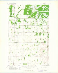
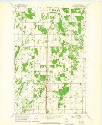 1962 Holt1964 Print · USGSMarshall County's rural landscape is captured in the early sixties as a network of rail and farmland centered on the town of Holt. Local historians can trace the Great Northern line, find Ringbo Ch, and map mid-century field boundaries.
 - 1962 Map of Greenbush SE, 1964 Print
 1962 Greenbush SE1964 Print · USGSThe agricultural borderlands of Roseau and Marshall counties come into focus during the early sixties, revealing a landscape defined by drainage and township lines. Researchers can locate the Lorenson Cem, a local Townhall, and the significant path of Judicial Ditch No 19.
 - 1962 Map of Gatzke, 1964 Print
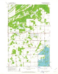
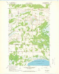
 1962 Gatzke1964 Print · USGSMarshall County in the early 1960s was a landscape defined by its vast wetlands and small rural settlements. Researchers can locate family burial sites at Moose River Cem and Lundstad Cem or trace the early boundaries of Gatzke and the Thief Lake shoreline.2 unique versions available
 - 1966 Map of Big Woods NE, 1968 Print
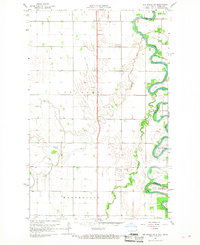
 1966 Big Woods NE1968 Print · USGSThe Red River Valley along the Minnesota-North Dakota border is captured here in the mid-1960s, showing a landscape defined by industrial-scale drainage and agriculture. Researchers can locate the Fork Cem near Snake Fork and trace the paths of Judicial Ditch No 9 and the Tamarac River.
 - 1966 Map of Oslo NE, 1968 Print
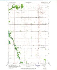
 1966 Oslo NE1968 Print · USGSThe Red River Valley in the mid-sixties shows a landscape of precise township grids and vital rail connections along the Minnesota-North Dakota border. Genealogists can trace rural family sites near Mesopotamia Cem, Oak Park Ch, and the Soo Line rail corridor.
 - 1966 Map of Big Woods, 1968 Print
 1966 Big Woods1968 Print · USGSThe Red River Valley landscape of the mid-1960s is captured here, showing the intricate drainage network along the Minnesota and North Dakota border. Researchers can locate early rural landmarks including the Big Woods Ch, Malm Cem, and the community Townhall.
 - 1966 Map of Oslo, 1968 Print
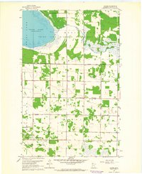
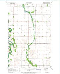
 1966 Oslo1968 Print · USGSThe Red River Valley in the mid-sixties shows a landscape defined by sharp river bends and the precision of the SOO LINE railroad. Genealogists and local historians can trace the community of Oslo, family landmarks like Riverside Cem, and the GREAT NORTHERN rail line.3 unique versions available
 - 1966 Map of Big Woods SW, 1968 Print
 1966 Big Woods SW1968 Print · USGSThe Red River valley in the late sixties shows a landscape of deep river bends and established prairie townships. Genealogists can trace property lines in Pulaski and Walshville or follow the wooded reaches of Big Woods and Oak Park.2 unique versions available
 - 1967 Map of Thief River Falls
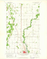
 1967 Thief River Falls1967 Print · USGSThe Red River Valley and the international border come alive in the 1960s, showing a landscape shaped by major rail lines and river commerce. Genealogists and historians can trace the paths of the Great Northern and Soo Line through towns like Thief River Falls, Grafton, and Hallock.
 - 1967 Map of Thief Lake, 1969 Print
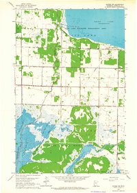
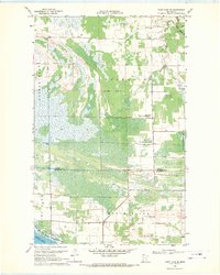
 1967 Thief Lake1969 Print · USGSNear the border of Roseau and Marshall Counties in the late sixties, this survey captures a landscape of wetlands and rural homesteads. Genealogists can locate family landmarks like the Gust National Cem, Klondike Ch, and Grass Lake Sch.
 - 1968 Map of Thief Lake SE, 1971 Print
 1968 Thief Lake SE1971 Print · USGSNorthwestern Minnesota in the late sixties shows a landscape of expansive wetlands and managed wildlife areas at the Roseau and Marshall County border. Researchers can locate the Palmville Cem, the rural Townhall, and the headwaters of the Moose River.
 - 1968 Map of Wannaska SW, 1971 Print
 1968 Wannaska SW1971 Print · USGSNorthwestern Minnesota in the late sixties shows a landscape of drainage and remote settlements at the Roseau-Marshall county line. Trace the local community at Casperson, find Bethlehem Ch, or locate the Golden Valley Cem.2 unique versions available
 - 1969 Map of Skime, 1971 Print
 1969 Skime1971 Print · USGSNorthern Minnesota's borderlands come into focus in the late sixties as the wilderness of the Beltrami Island State Forest meets rural settlements. Genealogists and local historians can locate the Bethesda Ch, the Reine Cem, and the small community of Skime.
End of results
Showing maps 1-25 of 25
Top cities of Marshall County
- Warren historical maps
- Stephen historical maps
- Argyle historical maps
- Alvarado historical maps
- Newfolden historical maps
- Oslo historical maps
See more
Frequently asked questions
- What are the different types of historical maps available for Marshall County?
- What is the oldest map of Marshall County?
- Where can I purchase historical maps of Marshall County for my home or office?
- Where can I download high-res historical maps of Marshall County?
- Are there historical topographic maps available for Marshall County?
- Is there historical aerial imagery available for Marshall County?
- Where are historical maps of Marshall County sourced from?