Old Maps of Picayune, Mississippi for Genealogy
Trace your family roots with 29 historic maps of Picayune. These high-res maps reveal old neighborhoods, homesites, landmarks, and streets — helping you uncover where your ancestors lived and how the area evolved over time.
- Explore historic neighborhoods: Identify where your relatives may have lived in the 1800s or 1900s.
- Compare maps over time: Trace the changes in streets, buildings, and landmarks for multi-generational research.
- Perfect for genealogy & ancestry research: Used by family historians and researchers to map out lineage and migration.
These maps are an incredible resource for exploring your personal connection to Picayune's past.
Picayune, MS maps
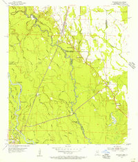
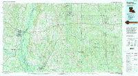
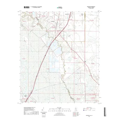
(29)- 1914 Map of Nicholson, 1957 Print
 1914 Nicholson1957 Print · USGSThe Pearl River swamp along the Louisiana-Mississippi border was a landscape of timber and tides during the early twentieth century. Genealogists can locate family-named settlements like Logtown and Gainsville or trace the early paths of the 3 Notch Road.2 unique versions available
 - 1921 Map of Nicholson
 1921 Nicholson1921 Print · USGSThe borderlands of Mississippi and Louisiana are captured here in the early 1920s, showing a river-driven landscape of timber and rail. Researchers can trace the riverfront communities of Gainsville and Logtown alongside the historic 3 Notch Road.
 - 1941 Map of Honey Island
 1941 Honey Island1941 Print · USGSThe lower Pearl River basin at the start of the 1940s reveals a dense network of swamp bayous and rail sidings. Genealogists and historians can trace the paths of Highway No 11 and the Southern railroad through Benton and past Honey Island.
 - 1953 Map of Mobile, 1968 Print
 1953 Mobile1968 Print · USGSThe Gulf Coast comes alive in this mid-century survey, from the streets of Mobile to the marshes of New Orleans. Trace family roots in coastal towns like Pass Christian and Bayou La Batre or locate military landmarks including Keesler AFB.3 unique versions available
 - 1955 Map of Nicholson, 1956 Print
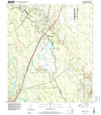
 1955 Nicholson1956 Print · USGSThe Pearl River bottomlands at the Mississippi-Louisiana border come to life in the mid-fifties, showing a landscape defined by braided bayous and timbered wetlands. Researchers can locate family landmarks like Turtleskin Cem and Oak Ridge Ch or trace the early footprint of Nicholson.5 unique versions available
 - 1957 Map of Mobile
 1957 Mobile1957 Print · USGSThe Gulf Coast in the mid-1950s reveals a bustling corridor of rail-and-river commerce connecting Alabama to Louisiana. Genealogists and historians can trace old settlements and military hubs from Keesler Afb to the coastal reaches of Ship Island and Bogalusa.3 unique versions available
 - 1958 Map of Picayune, 1959 Print
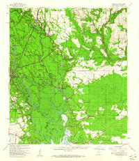
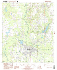
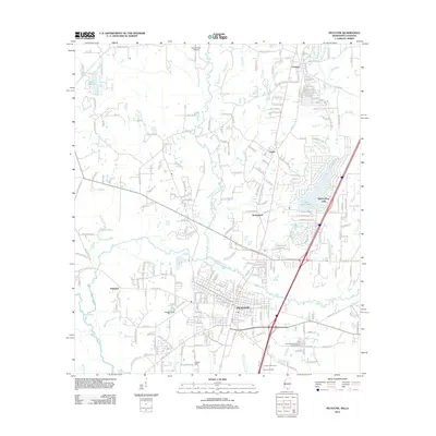
 1958 Picayune1959 Print · USGSPicayune and the surrounding Pearl River County countryside are captured here in the late fifties as the timber and rail economy shaped the landscape. Genealogists and local historians can trace rural family sites like Thigpen Cem, the Lee Sch, and the small settlement at Ozona.2 unique versions available
 - 1959 Map of Nicholson, 1960 Print
 1959 Nicholson1960 Print · USGSThe Pearl River valley in the late fifties was a network of riverfront settlements and deep-swamp bayous at the Mississippi-Louisiana border. Researchers can trace the river's winding course through Gainesville, locate family sites at Haaswood Cem, or find rural landmarks like Flattop Sch.3 unique versions available
 - 1960 Map of Mobile
 1960 Mobile1960 Print · USGSThe Gulf Coast at the dawn of the sixties shows a landscape of busy ports, military airbases, and barrier islands. Trace the rail lines of the Louisville & Nashville through BILOXI and Pascagoula or find family history in towns like Bayou La Batre and Poplarville.
 - 1963 Map of Mobile
 1963 Mobile1963 Print · USGSThe Gulf Coast at the dawn of the sixties shows a thriving maritime and military corridor from Louisiana to Alabama. Genealogists and historians can trace rail lines like the Louisville & Nashville RR and find landmarks from Brookley AFB to Fort Morgan.
 - 1965 Map of Mobile
 1965 Mobile1965 Print · USGSThe Gulf Coast at mid-century reveals a landscape of expanding ports and vital military installations from Louisiana to Alabama. Genealogists and historians can trace the growth of Biloxi, Pascagoula, and Mobile, alongside the sprawling De Soto National Forest.
 - 1982 Map of Gulfport, 1983 Print
 1982 Gulfport1983 Print · USGSThe Gulf Coast between Louisiana and Mississippi appears in the early eighties as a landscape of marshland and maritime industry. Researchers can trace the path of the Louisville and Nashville RR through towns like Waveland and De Lisle, or locate the sprawling National Space Technology Laboratories.2 unique versions available
 - 1984 Map of Bogalusa
 1984 Bogalusa1984 Print · USGSThe Pearl River basin on the Louisiana-Mississippi border comes into focus in the mid-1980s, showcasing a landscape of river-bottom swamps and timberlands. Local researchers can trace the growth of Bogalusa and Picayune or find rural landmarks like Macedonia Ch and Wheat Swamp.
 - 1984 Map of Mobile
 1984 Mobile1984 Print · USGSThe Gulf Coast at the height of the mid-eighties shows a landscape of rapid industrial growth and military significance. Researchers can trace the sprawling rail lines of the Illinois Central Gulf RR, locate the NASA Test Facility, or study the barrier island chain from Cat Island to Petit Bois Island.3 unique versions available
 - 1985 Map of Picayune
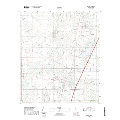
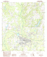 1985 Picayune1985 Print · USGSPicayune and the surrounding Pearl River County countryside are captured here in the mid-1980s as the area balanced city growth with its deep-seated timber and river heritage. Genealogists and local historians can trace family locations near Carriere, Ozona, and the residential developments of Hide-A-Way Lake.2 unique versions available
 - 1993 Map of Nicholson, 1995 Print
 1993 Nicholson1995 Print · USGSNicholson and the surrounding river lowlands are captured here in the early nineties as the NASA buffer zone meets the Pearl River basin. Genealogists can locate family sites like Old Palestine Ch, Cedar Grove Cem, and Corinth Ch among the many bayous.
 - 1994 Map of Bogalusa
 1994 Bogalusa1994 Print · USGSThe timber country and river bottoms of the Louisiana-Mississippi borderlands come alive in the mid-nineties. Genealogists and researchers can trace the rail-and-river geography of Bogalusa, the winding Pearl River, and family settlements like McNeill and Varnado.2 unique versions available
 - 1997 Map of Picayune, 1999 Print
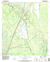
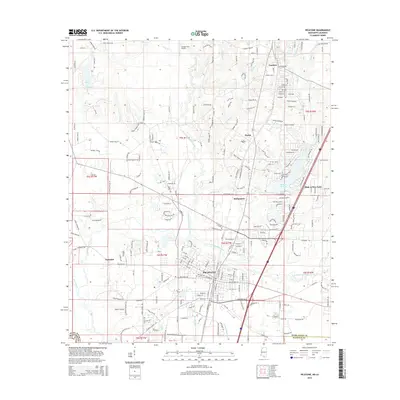
 1997 Picayune1999 Print · USGSPicayune and the surrounding Pearl River County pine woods are captured here during a period of steady growth in the late nineties. Local researchers can trace the development of Carriere and Ozona, or locate landmarks like Hide-A-Way Lake and the Municipal Airport.
 - 1998 Map of Nicholson, 2000 Print
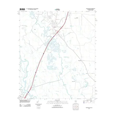
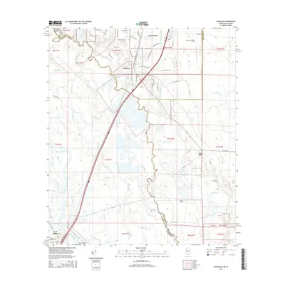
 1998 Nicholson2000 Print · USGSThe Pearl River delta comes into focus in the late nineties as a landscape of industrial gravel pits and aerospace boundaries. Genealogists and researchers can trace family sites like Cedar Grove Cem and Santa Rosa or locate landmarks like Jackson Landing.2 unique versions available
 - 2012 Map of Nicholson, 2012 Print
 2012 Nicholson2012 Print · USGSCovers Picayune, including Pearl River, Santa Rosa, and other nearby areas
 - 2012 Map of Picayune, 2012 Print
 2012 Picayune2012 Print · USGSCovers Picayune, including Richardson, Ozona, and other nearby areas
 - 2015 Map of Nicholson, 2015 Print
 2015 Nicholson2015 Print · USGSCovers Picayune, including Pearl River, Santa Rosa, and other nearby areas
 - 2015 Map of Picayune, 2015 Print
 2015 Picayune2015 Print · USGSCovers Picayune, including Richardson, Ozona, and other nearby areas
 - 2018 Map of Picayune, 2018 Print
 2018 Picayune2018 Print · USGSCovers Picayune, including Richardson, Ozona, and other nearby areas
 - 2018 Map of Nicholson, 2018 Print
 2018 Nicholson2018 Print · USGSCovers Picayune, including Pearl River, Santa Rosa, and other nearby areas
Showing maps 1-25 of 29
Top cities near Picayune
Frequently asked questions
- What are the different types of historical maps available for Picayune?
- What is the oldest map of Picayune?
- Where can I purchase historical maps of Picayune for my home or office?
- Where can I download high-res historical maps of Picayune?
- Are there historical topographic maps available for Picayune?
- Is there historical aerial imagery available for Picayune?
- Where are historical maps of Picayune sourced from?