1940s Maps of Odessa, Missouri
Explore 2 historic maps of Odessa from the 1940s. These maps offer a rare glimpse into what life looked like during the 1940s — showing old roads, neighborhoods, homes, and landmarks that have changed or disappeared over time.
Whether you're researching your family's past, planning a metal detecting trip, or studying how Odessa's landscape evolved across the 1940s, these high-resolution maps are a powerful tool for exploring the history of this region.
- Focus on a specific era: All maps on this page are from the 1940s, giving you a focused view of this time period.
- See what’s changed: Compare century-old streets, trails, and buildings to today's modern landscape using overlays and satellite layers.
- Research with precision: Use these maps for genealogy, historical research, land use analysis, or educational projects.
- View, download, or print: Maps are fully viewable online in high resolution, and can be downloaded or printed for your own records.
Start exploring Odessa's history through authentic maps from the 1940s. This is your window into the past.
Odessa, MO maps
(2)- 1947 Map of Jefferson City, 1949 Print
 1947 Jefferson City1949 Print · USGSCentral Missouri and the northern Ozarks come into focus in this late 1940s survey of the river-and-rail landscape. Genealogists and historians can trace the growth of Jefferson City and Sedalia or locate family roots near Bagnell Dam and the Lake of the Ozarks.
 - 1949 Map of Odessa North, 1976 Print
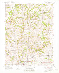 1949 Odessa North1976 Print · USGSLafayette County countryside is captured here in the late 1940s, just as the postwar era began to reshape rural Missouri. You can trace dozens of landmarks including the GULF MOBILE AND OHIO line, Greenton Ch, and old country schools like Cabbage Neck Sch.2 unique versions available
End of results
Showing maps 1-2 of 2
Top cities near Odessa
- Warrensburg historical maps
- Grain Valley historical maps
- Oak Grove historical maps
- Higginsville historical maps
- Lexington historical maps
- Buckner historical maps
See more
Frequently asked questions
- What are the different types of historical maps available for Odessa?
- What is the oldest map of Odessa?
- Where can I purchase historical maps of Odessa for my home or office?
- Where can I download high-res historical maps of Odessa?
- Are there historical topographic maps available for Odessa?
- Is there historical aerial imagery available for Odessa?
- Where are historical maps of Odessa sourced from?