1940s Maps of Chouteau County, Montana
Explore 4 historic maps of Chouteau County from the 1940s. These maps offer a rare glimpse into what life looked like during the 1940s — showing old roads, neighborhoods, homes, and landmarks that have changed or disappeared over time.
Whether you're researching your family's past, planning a metal detecting trip, or studying how Chouteau County's landscape evolved across the 1940s, these high-resolution maps are a powerful tool for exploring the history of this region.
- Focus on a specific era: All maps on this page are from the 1940s, giving you a focused view of this time period.
- See what’s changed: Compare century-old streets, trails, and buildings to today's modern landscape using overlays and satellite layers.
- Research with precision: Use these maps for genealogy, historical research, land use analysis, or educational projects.
- View, download, or print: Maps are fully viewable online in high resolution, and can be downloaded or printed for your own records.
Start exploring Chouteau County's history through authentic maps from the 1940s. This is your window into the past.
Chouteau County, MT maps
(4)- 1948 Map of Portage
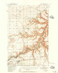 1948 Portage1948 Print · USGSThe Missouri River corridor near Great Falls is shown in the late 1940s, a landscape shaped by hydroelectric dams and expanding military aviation. Genealogists and researchers can trace local landmarks like Goffe Ranch, Salem Sch, and the Great Northern rail lines.4 unique versions available
 - 1949 Map of Portage
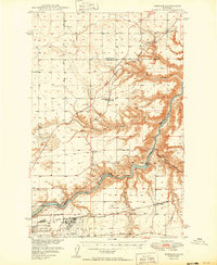 1949 Portage1949 Print · USGSThe Missouri River breaks through the Montana high plains in the late 1940s, revealing a landscape of vital hydroelectric dams and rural rail stops. Local historians can trace the development of Morony Dam, family holdings at Golie Ranch, and early settlements like Portage.2 unique versions available
 - 1949 Map of Timber Coulee, 1963 Print
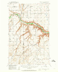 1949 Timber Coulee1963 Print · USGSTeton and Chouteau counties are shown here in the late 1940s, when the agricultural life of the Montana plains was tied to the river valley and small country schoolhouses. Researchers can locate the Jensen Elevator, follow the historic Bootlegger Trail, and find local landmarks like Knee Church.2 unique versions available
 - 1949 Map of Great Falls, 1966 Print
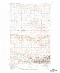 1949 Great Falls1966 Print · USGSMid-century Great Falls and the Missouri River basin are shown here during a period of post-war industrial and educational expansion. Researchers can trace the heritage of the area via the Bootlegger Trail, the Black Eagle Dam, and schools like Ursuline Academy and McKinley Sch.
End of results
Showing maps 1-4 of 4
Top cities of Chouteau County
Frequently asked questions
- What are the different types of historical maps available for Chouteau County?
- What is the oldest map of Chouteau County?
- Where can I purchase historical maps of Chouteau County for my home or office?
- Where can I download high-res historical maps of Chouteau County?
- Are there historical topographic maps available for Chouteau County?
- Is there historical aerial imagery available for Chouteau County?
- Where are historical maps of Chouteau County sourced from?