1990s Maps of Chouteau County, Montana
Explore 6 historic maps of Chouteau County from the 1990s. These maps offer a rare glimpse into what life looked like during the 1990s — showing old roads, neighborhoods, homes, and landmarks that have changed or disappeared over time.
Whether you're researching your family's past, planning a metal detecting trip, or studying how Chouteau County's landscape evolved across the 1990s, these high-resolution maps are a powerful tool for exploring the history of this region.
- Focus on a specific era: All maps on this page are from the 1990s, giving you a focused view of this time period.
- See what’s changed: Compare century-old streets, trails, and buildings to today's modern landscape using overlays and satellite layers.
- Research with precision: Use these maps for genealogy, historical research, land use analysis, or educational projects.
- View, download, or print: Maps are fully viewable online in high resolution, and can be downloaded or printed for your own records.
Start exploring Chouteau County's history through authentic maps from the 1990s. This is your window into the past.
Chouteau County, MT maps
(6)- 1993 Map of Rocky Boy, 1994 Print
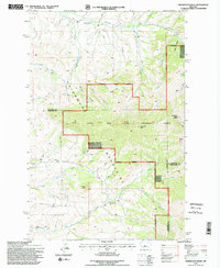
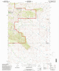
 1993 Rocky Boy1994 Print · USGSThe Bears Paw Mountains and the high plains of north-central Montana appear here in the early nineties, centered on the Rocky Boys Indian Reservation. You can trace the historic Bears Paw Battlefield and find isolated sites like Cleveland and the Blackjack Mine.
 - 1995 Map of Highwood Baldy
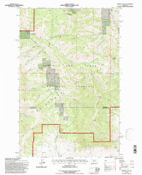
 1995 Highwood Baldy1995 Print · USGSThe Highwood Mountains in the mid-1990s offer a detailed view of the rugged terrain where Cascade, Chouteau, and Judith Basin counties meet. Researchers can trace the legacy of rural communities through sites like the Big Willow Cemetery, Mountain View Sch, and the Highwood Creek Community Hall.2 unique versions available
 - 1995 Map of Carter Mountain, 1997 Print
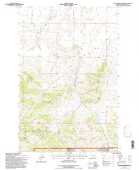 1995 Carter Mountain1997 Print · USGSChouteau County ranching and mountain landscapes come into focus in the mid-1990s as the Highwood Mountains rise above the plains. Genealogists and historians can locate the Shonkin Cow Camp, a secluded Cem, and drainage systems like Broker Coulee.
 - 1995 Map of Lepleys Creek, 1997 Print
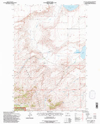 1995 Lepleys Creek1997 Print · USGSThe Highwood Mountains meet the Montana plains in the mid-1990s, showing a landscape defined by forest reserves and cattle country. Researchers can trace the drainages of Lepleys Creek and Alder Creek, or locate a lone Grave and Storage Bins near Kingsbury Lake.
 - 1995 Map of Arrow Peak, 1997 Print
 1995 Arrow Peak1997 Print · USGSThe Highwood Mountains of central Montana appear in detail during the mid-1990s as this survey covers the high peaks and forest boundaries. Researchers can trace the drainage basins of Smith Creek and Birch Creek while locating remote landmarks like the Highwood Guard Station.
 - 1995 Map of Palisade Butte, 1997 Print
 1995 Palisade Butte1997 Print · USGSThe Highwood Mountains stand at the border of Chouteau and Judith Basin counties in the mid-1990s. Genealogists and historians can trace the headwaters of Cottonwood Creek and locate landmarks like Palisade Butte and East Peak along the national forest boundary.
End of results
Showing maps 1-6 of 6
Top cities of Chouteau County
Frequently asked questions
- What are the different types of historical maps available for Chouteau County?
- What is the oldest map of Chouteau County?
- Where can I purchase historical maps of Chouteau County for my home or office?
- Where can I download high-res historical maps of Chouteau County?
- Are there historical topographic maps available for Chouteau County?
- Is there historical aerial imagery available for Chouteau County?
- Where are historical maps of Chouteau County sourced from?