1980s Maps of Flathead County, Montana
Explore 15 historic maps of Flathead County from the 1980s. These maps offer a rare glimpse into what life looked like during the 1980s — showing old roads, neighborhoods, homes, and landmarks that have changed or disappeared over time.
Whether you're researching your family's past, planning a metal detecting trip, or studying how Flathead County's landscape evolved across the 1980s, these high-resolution maps are a powerful tool for exploring the history of this region.
- Focus on a specific era: All maps on this page are from the 1980s, giving you a focused view of this time period.
- See what’s changed: Compare century-old streets, trails, and buildings to today's modern landscape using overlays and satellite layers.
- Research with precision: Use these maps for genealogy, historical research, land use analysis, or educational projects.
- View, download, or print: Maps are fully viewable online in high resolution, and can be downloaded or printed for your own records.
Start exploring Flathead County's history through authentic maps from the 1980s. This is your window into the past.
Flathead County, MT maps
(15)- 1980 Map of Polson, 1982 Print
 1980 Polson1982 Print · USGSThe Flathead Indian Reservation and its surrounding timberlands are captured here in the early eighties. Genealogists and historians can trace the development of Polson, locate remote sites like the Flathead Mine, and follow the Burlington Northern rail line through Pablo and Ronan.
 - 1981 Map of Whitefish Range, 1982 Print
 1981 Whitefish Range1982 Print · USGSThe Whitefish Range and Glacier National Park are shown here in the early eighties, documenting a massive wilderness landscape. Researchers can trace remote mountain outposts like Polebridge and rail-town history along the Burlington Northern near Trego and Olney.
 - 1981 Map of Hungry Horse Reservoir, 1982 Print
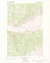
 1981 Hungry Horse Reservoir1982 Print · USGSThe Flathead region in the early eighties shows a wilderness managed through rail and reservoir. Genealogists and historians can trace rail-stop settlements like Nyack, Essex, and Summit along the Burlington Northern line and the John F Stevens Canyon.
 - 1981 Map of Kalispell, 1982 Print
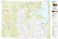
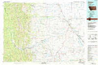
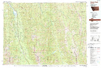
 1981 Kalispell1982 Print · USGSThe Flathead Valley in the early eighties shows a landscape defined by timber, tourism, and transit. Genealogists and historians can trace the growth of Evergreen, Bigfork, and Somers or locate early aviation landmarks like the Glacier Park Intl Airport.
 - 1982 Map of Lake Mary Ronan
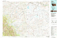
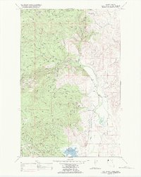
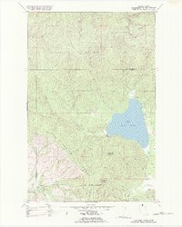 1982 Lake Mary Ronan1982 Print · USGSThe mountains and waters of northwestern Montana are captured here in the early eighties. Researchers can trace the rugged Hog Heaven Range or locate the remote settlement of Cromwell and the trails near Lake Mary Ronan.
 - 1982 Map of Irvine Lookout Tower
 1982 Irvine Lookout Tower1982 Print · USGSThe Flathead Indian Reservation and the Hog Heaven Range are captured here in the early eighties. Genealogists and local historians can trace the boundaries of Bower Ranch and Pablo Ranch, or locate landmarks like the Irvine Lookout Tower.
 - 1982 Map of Rose Crossing, 1983 Print
 1982 Rose Crossing1983 Print · USGSThe Flathead Valley in the early eighties shows a landscape of river-bottom farms and emerging regional infrastructure. Genealogists and local historians can locate the Birch Grove Sch, Trinity Cem, and the Midway Grange near the Whitefish River.
 - 1984 Map of Choteau
 1984 Choteau1984 Print · USGSThe Teton River country comes to life in this mid-eighties record of the Montana plains and mountains. Trace the footprints of early ranching and farming settlements like Farmington and Eastham Junction, or explore the unique Hutterite settlements at Miller Colony and New Rockport Colony.
 - 1984 Map of Valier
 1984 Valier1984 Print · USGSNorthwestern Montana in the mid-1980s reveals a unique landscape of Hutterite agricultural colonies and high mountain wilderness. Genealogists and historians can trace the irrigation networks and rail stops from Valier to Birch Creek Colony and the Kellogg Mine.
 - 1987 Map of Kofford Ridge
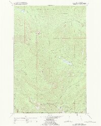
 1987 Kofford Ridge1987 Print · USGSThe Hog Heaven Range in the late 1980s reveals a landscape defined by high-country mining and remote ranching. Researchers can locate specific silver and lead operations like the West Flathead Mine and Battle Butte Mine or the isolated Wooster Ranch.
 - 1988 Map of Niarada
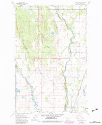
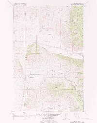 1988 Niarada1988 Print · USGSIn the northwestern corner of the reservation during the late 1980s, the terrain around the border of Sanders, Flathead, and Lake counties reveals a remote ranching landscape. Researchers can locate the Battle Butte Sch, the Niarada townsite, and the local Cem tucked near Sullivan Creek.
 - 1988 Map of Swan Peak, 1989 Print
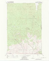
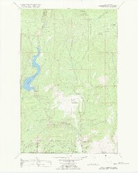
 1988 Swan Peak1989 Print · USGSSettlement in the Swan River Valley and the Bob Marshall Wilderness are captured in this late 1980s survey. Researchers can locate remote backcountry sites like the Spotted Bear Airport, the village of Condon, and the Swan Lake shoreline.
 - 1989 Map of Mill Pocket Creek
 1989 Mill Pocket Creek1989 Print · USGSThe Flathead Indian Reservation in the late eighties reveals a landscape of complex water management and high-country forestry. Researchers can trace the path of the Camas Canal or locate local landmarks like McKay Cem and Lozeau Flats.
 - 1989 Map of Murr Peak
 1989 Murr Peak1989 Print · USGSHigh mountain peaks and national forest boundaries defined this Montana wilderness in the late eighties. Follow a primitive Pack Trail to reach the heights of Murr Peak or Castle Rock, and locate the remote settlement of Pinehill near the reservation border.
 - 1989 Map of Hubbart Reservoir
 1989 Hubbart Reservoir1989 Print · USGSIn the late twentieth century, this portion of the Flathead Indian Reservation was a landscape of managed forests and alpine water systems. Researchers can trace the river's path from Conrad Camp to Hubbart Reservoir and locate the Hubbard Lookout.
End of results
Showing maps 1-15 of 15
Top cities of Flathead County
- Kalispell historical maps
- Whitefish historical maps
- Columbia Falls historical maps
- West Glacier historical maps
- Olney historical maps
Frequently asked questions
- What are the different types of historical maps available for Flathead County?
- What is the oldest map of Flathead County?
- Where can I purchase historical maps of Flathead County for my home or office?
- Where can I download high-res historical maps of Flathead County?
- Are there historical topographic maps available for Flathead County?
- Is there historical aerial imagery available for Flathead County?
- Where are historical maps of Flathead County sourced from?