1910s Maps of Flathead County, Montana
Explore 6 historic maps of Flathead County from the 1910s. These maps offer a rare glimpse into what life looked like during the 1910s — showing old roads, neighborhoods, homes, and landmarks that have changed or disappeared over time.
Whether you're researching your family's past, planning a metal detecting trip, or studying how Flathead County's landscape evolved across the 1910s, these high-resolution maps are a powerful tool for exploring the history of this region.
- Focus on a specific era: All maps on this page are from the 1910s, giving you a focused view of this time period.
- See what’s changed: Compare century-old streets, trails, and buildings to today's modern landscape using overlays and satellite layers.
- Research with precision: Use these maps for genealogy, historical research, land use analysis, or educational projects.
- View, download, or print: Maps are fully viewable online in high resolution, and can be downloaded or printed for your own records.
Start exploring Flathead County's history through authentic maps from the 1910s. This is your window into the past.
Flathead County, MT maps
(6)- 1913 Map of Marias Pass
 1913 Marias Pass1913 Print · USGSThe Continental Divide and the Great Northern Railroad meet at the crest of the Rockies in the years just after Glacier's establishment. Local historians can trace early rail stations like Lubec, the Midvale settlement, and remote outposts such as Three Forks Rangers Cabin.3 unique versions available
 - 1913 Map of Stryker, 1960 Print
 1913 Stryker1960 Print · USGSNorthwest Montana at the start of the twentieth century was a landscape of remote rail outposts and high-country forestry along the Great Northern. Researchers can locate vanished infrastructure like the Meadow Creek School or trace early forest service history at Point of Rock Ranger Station.
 - 1914 Map of Nyack
 1914 Nyack1914 Print · USGSThe Middle Fork Flathead River corridor is captured here during the early days of Glacier National Park. Historians and researchers can trace the Great Northern rail line through remote stops at Nyack, Essex, and Java.3 unique versions available
 - 1914 Map of Heart Butte, 1959 Print
 1914 Heart Butte1959 Print · USGSThe foothills and plains of Pondera and Teton Counties are captured here in the early 1900s as the wilderness was being organized by early forestry and ranching. Genealogists can trace early homestead life via the Terryman School, Family, and the Blackleaf Ranger Station.
 - 1916 Map of Stryker
 1916 Stryker1916 Print · USGSRailroad-driven development in the early twentieth century defined the corridor from Stryker to Olney along the Great Northern line. Researchers can trace the era's remote infrastructure through landmarks like Butcher Cabin and the Glen Lake School.3 unique versions available
 - 1918 Map of Heart Butte
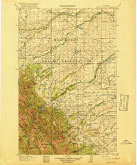 1918 Heart Butte1918 Print · USGSThe northern Montana plains meet the high Divide in the early twentieth century, showing the interface of the Blackfeet Indian Reservation and the national forest. Genealogists and historians can locate early rural schools like Jensen School and frontier outposts such as Hagans Crossing and the Blackleaf Ranger Station.3 unique versions available
End of results
Showing maps 1-6 of 6
Top cities of Flathead County
- Kalispell historical maps
- Whitefish historical maps
- Columbia Falls historical maps
- West Glacier historical maps
- Olney historical maps
Frequently asked questions
- What are the different types of historical maps available for Flathead County?
- What is the oldest map of Flathead County?
- Where can I purchase historical maps of Flathead County for my home or office?
- Where can I download high-res historical maps of Flathead County?
- Are there historical topographic maps available for Flathead County?
- Is there historical aerial imagery available for Flathead County?
- Where are historical maps of Flathead County sourced from?