Old Maps of Flathead County, Montana for Metal Detecting
Plan your next treasure hunt with 1,043 historic maps of Flathead County. Find old homesites, ghost towns, trails, and gathering spots that may be lost to time — perfect for identifying promising metal detecting locations.
- Locate forgotten sites: Uncover places like long-lost settlements, abandoned rail lines, or gathering spots.
- Plan better hunts: Use map overlays combined with LiDAR or satellite views to narrow in on historically rich areas.
- Made for detectorists: Thousands of hobbyists use these maps to discover relics, coins, and hidden history.
Use these historic maps to boost your research and find new opportunities beneath the surface of Flathead County.
Flathead County, MT maps
(1,043)- 1901 Map of Browning, 1959 Print
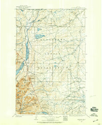 1901 Browning1959 Print · USGSThe Blackfeet Indian Reservation and eastern Glacier National Park meet in this early twentieth-century survey. Genealogists and historians can trace old homesteads and landmarks like Galbreath Ranch, the Pontresina Sch, and the Great Northern rail corridor.
 - 1903 Map of Browning
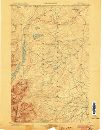 1903 Browning1903 Print · USGSThe Blackfeet Reservation and the high peaks of northern Montana appear here shortly after the turn of the century. You can trace the path of the Great Northern R. R. through Browning or locate early settlements like St. Mary along the glacial lakes.2 unique versions available
 - 1903 Map of Saypo
 1903 Saypo1903 Print · USGSTeton and Lewis and Clark counties appear at the dawn of the century as a landscape of remote mountain forest reserves and early prairie homesteads. Researchers can trace the holdings of pioneer families at Clark Bros Ranch and Campbell's Ranch or locate early industry at McGunks Sawmill and the local Coal Mine.7 unique versions available
 - 1904 Map of Chief Mountain
 1904 Chief Mountain1904 Print · USGSThe northern Rockies at the dawn of the century were a rugged borderland of forest reserves and tribal lands. Researchers can trace early outposts like Kipps Cabin and Altyn, or locate family-named sites including Rogers Ranch and Geduhn's.8 unique versions available
 - 1906 Map of Kintla Lakes
 1906 Kintla Lakes1906 Print · USGSThe high peaks of the northern Rockies appear in sharp relief during the first years of the century, just south of the Canadian border. Genealogists and historians can locate early homesteads like Jefferson's Ranch and Christensen's Ranch alongside glacial features like Agassiz Glacier.4 unique versions available
 - 1913 Map of Marias Pass
 1913 Marias Pass1913 Print · USGSThe Continental Divide and the Great Northern Railroad meet at the crest of the Rockies in the years just after Glacier's establishment. Local historians can trace early rail stations like Lubec, the Midvale settlement, and remote outposts such as Three Forks Rangers Cabin.3 unique versions available
 - 1913 Map of Stryker, 1960 Print
 1913 Stryker1960 Print · USGSNorthwest Montana at the start of the twentieth century was a landscape of remote rail outposts and high-country forestry along the Great Northern. Researchers can locate vanished infrastructure like the Meadow Creek School or trace early forest service history at Point of Rock Ranger Station.
 - 1914 Map of Nyack
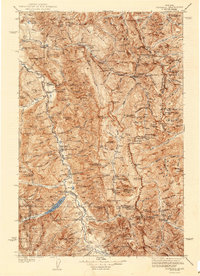
 1914 Nyack1914 Print · USGSThe Middle Fork Flathead River corridor is captured here during the early days of Glacier National Park. Historians and researchers can trace the Great Northern rail line through remote stops at Nyack, Essex, and Java.3 unique versions available
 - 1914 Map of Heart Butte, 1959 Print
 1914 Heart Butte1959 Print · USGSThe foothills and plains of Pondera and Teton Counties are captured here in the early 1900s as the wilderness was being organized by early forestry and ranching. Genealogists can trace early homestead life via the Terryman School, Family, and the Blackleaf Ranger Station.
 - 1916 Map of Stryker
 1916 Stryker1916 Print · USGSRailroad-driven development in the early twentieth century defined the corridor from Stryker to Olney along the Great Northern line. Researchers can trace the era's remote infrastructure through landmarks like Butcher Cabin and the Glen Lake School.3 unique versions available
 - 1918 Map of Heart Butte
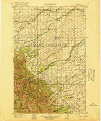 1918 Heart Butte1918 Print · USGSThe northern Montana plains meet the high Divide in the early twentieth century, showing the interface of the Blackfeet Indian Reservation and the national forest. Genealogists and historians can locate early rural schools like Jensen School and frontier outposts such as Hagans Crossing and the Blackleaf Ranger Station.3 unique versions available
 - 1920 Map of Flathead Lake
 1920 Flathead Lake1920 Print · USGSWestern Montana at the dawn of the twenties reveals a landscape being transformed by irrigation and rail. Genealogists can trace family roots in early settlements like Polson, Ronan, and Dayton, or locate landmarks such as Wild Horse I. and the Pablo Reservoir.
 - 1920 Map of Jennings
 1920 Jennings1920 Print · USGSNorthwest Montana in the early twenties is captured here as a landscape of timber, rail, and isolated homesteads. Genealogists can trace family-named locations such as Corries Ranch and Deegan Ranch, or locate the site of the Mamicke P.O. near the Fisher River.
 - 1935 Map of Thompson Lakes
 1935 Thompson Lakes1935 Print · USGSNorthwestern Montana in the mid-thirties was a rugged domain of timber management and rail-line outposts. Researchers can trace the Great Northern Ry through Jennings or locate remote schools like the Thompson River Sch and Manicke Sch.3 unique versions available
 - 1936 Map of Silvertip
 1936 Silvertip1936 Print · USGSThe Flathead National Forest wilderness in the mid-1930s was a land of isolated outposts and early aviation. Researchers can trace the early ranger station network at Spotted Bear Ranger Sta and remote landmarks like Indian Camp or Limestone Cabin.3 unique versions available
 - 1938 Map of Chief Mountain, 1953 Print
 1938 Chief Mountain1953 Print · USGSGlacier National Park and the neighboring Blackfeet Indian Reservation are shown here during the late thirties as the modern highway system was taking shape. You can trace the early tourism and management landscape through Going-to-the-Sun Chalet, Many Glacier, and the remote Sperry Chalet.8 unique versions available
 - 1938 Map of Kintla Lakes, 1954 Print
 1938 Kintla Lakes1954 Print · USGSThe northern reaches of the Montana Rockies are shown here during the early years of the National Park Service. Researchers can locate early homesteads and remote outposts like Brills Ranch, Polebridge, and Theo Christensen Ranch along the Flathead River.
 - 1942 Map of Thompson Lakes
 1942 Thompson Lakes1942 Print · USGSNorthwest Montana during the early 1940s remained a landscape of timber and rail, where the Great Northern Railway hugged the banks of the Kootenai River. Researchers can trace the network of forest lookouts like Warland Pk Lookout and find early rural sites including Pleasant Valley Sch.2 unique versions available
 - 1942 Map of Silvertip
 1942 Silvertip1942 Print · USGSThe South Fork of the Flathead River backcountry is captured here in the late thirties, showing a wilderness managed by air and trail. Locate historic outposts like Big Prairie Ranger Sta, early airstrips, and remote cabins such as Limestone Cabin.2 unique versions available
 - 1943 Map of Kalispell
 1943 Kalispell1943 Print · USGSThe Flathead Valley's mid-century rail and river networks are preserved here as Kalispell expanded. Genealogists and historians can trace defunct river crossings like Therriaults Ferry, the old Demersville site, and the rail path of the Somers Kalispell Br.
 - 1955 Map of Choteau, 1978 Print
 1955 Choteau1978 Print · USGSWestern Montana during the mid-fifties is captured here as a land of rugged high-country wilderness and vital eastern plains irrigation. Genealogists and historians can locate remote outposts like Condon, the communal Miller Colony, and the rail stops of the Chicago Milwaukee St Paul and Pacific.
 - 1956 Map of Wallace, 1966 Print
 1956 Wallace1966 Print · USGSWestern Montana and the Idaho panhandle meet in this mid-century survey of the Bitterroot and Cabinet Mountains. Genealogists and historians can trace the rail-and-river economy through the Northern Pacific line and settlements like Thompson Falls or St. Ignatius.3 unique versions available
 - 1957 Map of Choteau
 1957 Choteau1957 Print · USGSMontana's mountain front meets the eastern plains in the mid-fifties, showing the transition from forested wilderness to irrigated ranch land. Genealogists and historians can trace the rail lines of the Great Northern and find settlements like Choteau, Augusta, and Seeley Lake.
 - 1957 Map of Kalispell, 1967 Print
 1957 Kalispell1967 Print · USGSNorthwest Montana in the late fifties showcases a mountain landscape transitioning between wilderness and industry. Genealogists and researchers can trace the Great Northern rail corridor through Kalispell and Whitefish, or locate landmarks like the Montana Soldiers Home and Hungry Horse Reservoir.3 unique versions available
 - 1958 Map of Choteau
 1958 Choteau1958 Print · USGSMontana's front range meets the high wilderness in the late fifties, where the Great Northern railway connects ranching towns to the eastern plains. Researchers can trace the development of irrigation at Bynum Reservoir or locate remote camps like the Big Prairie District Ranger Station and Helmville.2 unique versions available
Showing maps 1-25 of 1,043
Top cities of Flathead County
- Kalispell historical maps
- Whitefish historical maps
- Columbia Falls historical maps
- West Glacier historical maps
- Olney historical maps
Frequently asked questions
- What are the different types of historical maps available for Flathead County?
- What is the oldest map of Flathead County?
- Where can I purchase historical maps of Flathead County for my home or office?
- Where can I download high-res historical maps of Flathead County?
- Are there historical topographic maps available for Flathead County?
- Is there historical aerial imagery available for Flathead County?
- Where are historical maps of Flathead County sourced from?