1970s Maps of Gallatin County, Montana
Explore 2 historic maps of Gallatin County from the 1970s. These maps offer a rare glimpse into what life looked like during the 1970s — showing old roads, neighborhoods, homes, and landmarks that have changed or disappeared over time.
Whether you're researching your family's past, planning a metal detecting trip, or studying how Gallatin County's landscape evolved across the 1970s, these high-resolution maps are a powerful tool for exploring the history of this region.
- Focus on a specific era: All maps on this page are from the 1970s, giving you a focused view of this time period.
- See what’s changed: Compare century-old streets, trails, and buildings to today's modern landscape using overlays and satellite layers.
- Research with precision: Use these maps for genealogy, historical research, land use analysis, or educational projects.
- View, download, or print: Maps are fully viewable online in high resolution, and can be downloaded or printed for your own records.
Start exploring Gallatin County's history through authentic maps from the 1970s. This is your window into the past.
Gallatin County, MT maps
(2)- 1971 Map of Willow Creek Reservoir, 1975 Print
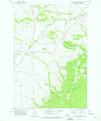 1971 Willow Creek Reservoir1975 Print · USGSMeagher County ranching and forest lands are captured in the early 1970s, centered on the Willow Creek Reservoir. Trace the network of Pack Trails through the Castle Mountains and locate isolated features like Trinity Spring and Landing Strips.
 - 1976 Map of Townsend, 1994 Print
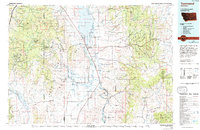 1976 Townsend1994 Print · USGSBroadwater County and the surrounding peaks come into focus during the mid-seventies, showing the intersection of heavy mining history and mountain wilderness. Genealogists and historians can trace the foundations of Radersburg, the remote rail junction at Lombard, and dozens of named claims like the East Pacific Mine.
End of results
Showing maps 1-2 of 2
Top cities of Gallatin County
- Bozeman historical maps
- Belgrade historical maps
- Big Sky historical maps
- Three Forks historical maps
- Manhattan historical maps
- West Yellowstone historical maps
See more
Frequently asked questions
- What are the different types of historical maps available for Gallatin County?
- What is the oldest map of Gallatin County?
- Where can I purchase historical maps of Gallatin County for my home or office?
- Where can I download high-res historical maps of Gallatin County?
- Are there historical topographic maps available for Gallatin County?
- Is there historical aerial imagery available for Gallatin County?
- Where are historical maps of Gallatin County sourced from?