1990s Maps of Gallatin County, Montana
Explore 5 historic maps of Gallatin County from the 1990s. These maps offer a rare glimpse into what life looked like during the 1990s — showing old roads, neighborhoods, homes, and landmarks that have changed or disappeared over time.
Whether you're researching your family's past, planning a metal detecting trip, or studying how Gallatin County's landscape evolved across the 1990s, these high-resolution maps are a powerful tool for exploring the history of this region.
- Focus on a specific era: All maps on this page are from the 1990s, giving you a focused view of this time period.
- See what’s changed: Compare century-old streets, trails, and buildings to today's modern landscape using overlays and satellite layers.
- Research with precision: Use these maps for genealogy, historical research, land use analysis, or educational projects.
- View, download, or print: Maps are fully viewable online in high resolution, and can be downloaded or printed for your own records.
Start exploring Gallatin County's history through authentic maps from the 1990s. This is your window into the past.
Gallatin County, MT maps
(5)- 1992 Map of Bozeman
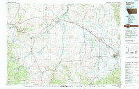 1992 Bozeman1992 Print · USGSThe Gallatin and Madison valleys are captured here in the early nineties, centered on the growth of the Montana State University area. Researchers can trace the legacy of mining in the Tobacco Root Mountains or locate landmarks like the Madison Buffalo Jump State Monument and Church Hill Church.
 - 1992 Map of Livingston
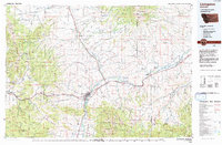 1992 Livingston1992 Print · USGSPark County in the early nineties remains a landscape of river valleys and high wilderness, centered on the historic rail hub of Livingston. Researchers can trace the Burlington Northern Railroad through mountain passes and locate rural markers like the Coal Mine and Clyde Park.
 - 1992 Map of Gardiner, 1993 Print
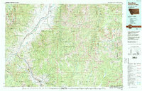 1992 Gardiner1993 Print · USGSThe northern gateway to Yellowstone and the high peaks of the Absaroka Range are captured here in the early nineties. Researchers can trace historic settlements like Jardine and Chico Hot Springs or locate the North Entrance near Gardiner.2 unique versions available
 - 1993 Map of Ringling
 1993 Ringling1993 Print · USGSMeagher County in the early nineties remains a landscape of high-altitude ranching and mining history framed by the Crazy Mountains. Researchers can trace the legacy of the silver boom at Castle Town and the Cumberland Mine or locate early rail sidings like Loweth and Bruno.
 - 1993 Map of Hebgen Lake
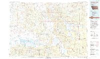 1993 Hebgen Lake1993 Print · USGSThe high mountain passes and vast river basins of the Montana-Idaho border come into focus in the early nineties. Genealogists and historians can trace the remote settlement of Lakeview and the development of West Yellowstone near the Red Rock Lakes National Wildlife Refuge.2 unique versions available
End of results
Showing maps 1-5 of 5
Top cities of Gallatin County
- Bozeman historical maps
- Belgrade historical maps
- Big Sky historical maps
- Three Forks historical maps
- Manhattan historical maps
- West Yellowstone historical maps
See more
Frequently asked questions
- What are the different types of historical maps available for Gallatin County?
- What is the oldest map of Gallatin County?
- Where can I purchase historical maps of Gallatin County for my home or office?
- Where can I download high-res historical maps of Gallatin County?
- Are there historical topographic maps available for Gallatin County?
- Is there historical aerial imagery available for Gallatin County?
- Where are historical maps of Gallatin County sourced from?