1940s Maps of Lewis and Clark County, Montana
Explore 4 historic maps of Lewis and Clark County from the 1940s. These maps offer a rare glimpse into what life looked like during the 1940s — showing old roads, neighborhoods, homes, and landmarks that have changed or disappeared over time.
Whether you're researching your family's past, planning a metal detecting trip, or studying how Lewis and Clark County's landscape evolved across the 1940s, these high-resolution maps are a powerful tool for exploring the history of this region.
- Focus on a specific era: All maps on this page are from the 1940s, giving you a focused view of this time period.
- See what’s changed: Compare century-old streets, trails, and buildings to today's modern landscape using overlays and satellite layers.
- Research with precision: Use these maps for genealogy, historical research, land use analysis, or educational projects.
- View, download, or print: Maps are fully viewable online in high resolution, and can be downloaded or printed for your own records.
Start exploring Lewis and Clark County's history through authentic maps from the 1940s. This is your window into the past.
Lewis and Clark County, MT maps
(4)- 1942 Map of Silvertip
 1942 Silvertip1942 Print · USGSThe South Fork of the Flathead River backcountry is captured here in the late thirties, showing a wilderness managed by air and trail. Locate historic outposts like Big Prairie Ranger Sta, early airstrips, and remote cabins such as Limestone Cabin.2 unique versions available
 - 1943 Map of Hogan
 1943 Hogan1943 Print · USGSCrossing the Continental Divide during the early twentieth century, this survey shows the high-country landscape between the Sun and Dearborn rivers. Researchers can trace early settlements like Stearns and Hogan, or find remote landmarks such as Silver Camp and the Dry Creek Reservoir Site.
 - 1947 Map of Butte, 1949 Print
 1947 Butte1949 Print · USGSWestern Montana at the peak of its rail-and-river era shows the vital connections between the mining and industrial centers of Butte and Helena. Researchers can trace the three major railroad lines serving mountain settlements like Garrison, Philipsburg, and Warm Springs.2 unique versions available
 - 1948 Map of White Sulphur Springs, 1951 Print
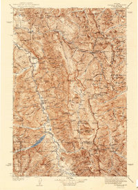
 1948 White Sulphur Springs1951 Print · USGSMontana's capital and the high country of the Big Belt Mountains come alive in this mid-century survey. Trace the early hydroelectric developments at Canyon Ferry Dam or follow the historic rail lines through Ringling and Townsend.
End of results
Showing maps 1-4 of 4
Top cities of Lewis and Clark County
Frequently asked questions
- What are the different types of historical maps available for Lewis and Clark County?
- What is the oldest map of Lewis and Clark County?
- Where can I purchase historical maps of Lewis and Clark County for my home or office?
- Where can I download high-res historical maps of Lewis and Clark County?
- Are there historical topographic maps available for Lewis and Clark County?
- Is there historical aerial imagery available for Lewis and Clark County?
- Where are historical maps of Lewis and Clark County sourced from?