1920s Maps of Missoula County, Montana
Explore 2 historic maps of Missoula County from the 1920s. These maps offer a rare glimpse into what life looked like during the 1920s — showing old roads, neighborhoods, homes, and landmarks that have changed or disappeared over time.
Whether you're researching your family's past, planning a metal detecting trip, or studying how Missoula County's landscape evolved across the 1920s, these high-resolution maps are a powerful tool for exploring the history of this region.
- Focus on a specific era: All maps on this page are from the 1920s, giving you a focused view of this time period.
- See what’s changed: Compare century-old streets, trails, and buildings to today's modern landscape using overlays and satellite layers.
- Research with precision: Use these maps for genealogy, historical research, land use analysis, or educational projects.
- View, download, or print: Maps are fully viewable online in high resolution, and can be downloaded or printed for your own records.
Start exploring Missoula County's history through authentic maps from the 1920s. This is your window into the past.
Missoula County, MT maps
(2)- 1921 Map of Drummond
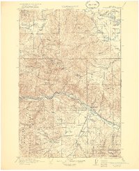 1921 Drummond1921 Print · USGSGranite and Missoula counties are seen here in the years following the Great War, as mining camps and valley ranches defined the local economy. Genealogists can trace family homesteads like Williams Ranch or locate rural landmarks including Sunset School and Garnet.3 unique versions available
 - 1921 Map of Elbow Lake
 1921 Elbow Lake1921 Print · USGSThe Montana wilderness near Missoula is captured here during the early 1920s, showcasing the transition of the former reservation lands. Genealogists and hikers can trace early routes like the Gordon Trail and locate historical landmarks such as Gordon Ranch and Holland Lake R.S.
End of results
Showing maps 1-2 of 2
Top cities of Missoula County
Frequently asked questions
- What are the different types of historical maps available for Missoula County?
- What is the oldest map of Missoula County?
- Where can I purchase historical maps of Missoula County for my home or office?
- Where can I download high-res historical maps of Missoula County?
- Are there historical topographic maps available for Missoula County?
- Is there historical aerial imagery available for Missoula County?
- Where are historical maps of Missoula County sourced from?