1970s Maps of Missoula County, Montana
Explore 4 historic maps of Missoula County from the 1970s. These maps offer a rare glimpse into what life looked like during the 1970s — showing old roads, neighborhoods, homes, and landmarks that have changed or disappeared over time.
Whether you're researching your family's past, planning a metal detecting trip, or studying how Missoula County's landscape evolved across the 1970s, these high-resolution maps are a powerful tool for exploring the history of this region.
- Focus on a specific era: All maps on this page are from the 1970s, giving you a focused view of this time period.
- See what’s changed: Compare century-old streets, trails, and buildings to today's modern landscape using overlays and satellite layers.
- Research with precision: Use these maps for genealogy, historical research, land use analysis, or educational projects.
- View, download, or print: Maps are fully viewable online in high resolution, and can be downloaded or printed for your own records.
Start exploring Missoula County's history through authentic maps from the 1970s. This is your window into the past.
Missoula County, MT maps
(4)- 1970 Map of Morrell Lake, 1973 Print
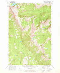 1970 Morrell Lake1973 Print · USGSThe high Divide country of the Mission and Swan ranges appears in 1970 just as it was being managed as a vast wilderness crossroads. Trace the historic footpaths through the high country including the Pyramid Pass Trail and remote waters like Morrell and George Lake.2 unique versions available
 - 1970 Map of Shaw Creek, 1973 Print
 1970 Shaw Creek1973 Print · USGSPowell County and the primitive Bob Marshall Wilderness are captured in the early 1970s, showing a landscape defined by horse trails and remote peaks. Trace historic routes like the Big Salmon Pack Trail to landmarks like the Shaw Creek Guard Sta.3 unique versions available
 - 1970 Map of Big Salmon Lake West, 1973 Print
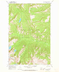
 1970 Big Salmon Lake West1973 Print · USGSMontana's high backcountry comes alive in the early seventies, detailing the primitive reaches of the Bob Marshall Wilderness. Trace the network of Pack Trails and Foot Trails connecting Pendant Guard Sta to Salmon Point.2 unique versions available
 - 1976 Map of Choteau
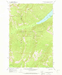
 1976 Choteau1976 Print · USGSThe Montana Rocky Mountain Front meets the plains in the 1970s, showcasing the high-altitude wilderness and the irrigation-fed ranching country. Trace the Great Northern Railway through Choteau or locate rural landmarks like the Farmington Cemetery and Gibson Reservoir.
End of results
Showing maps 1-4 of 4
Top cities of Missoula County
Frequently asked questions
- What are the different types of historical maps available for Missoula County?
- What is the oldest map of Missoula County?
- Where can I purchase historical maps of Missoula County for my home or office?
- Where can I download high-res historical maps of Missoula County?
- Are there historical topographic maps available for Missoula County?
- Is there historical aerial imagery available for Missoula County?
- Where are historical maps of Missoula County sourced from?