1970s Maps of Brockton District, Montana
Explore 11 historic maps of Brockton District from the 1970s. These maps offer a rare glimpse into what life looked like during the 1970s — showing old roads, neighborhoods, homes, and landmarks that have changed or disappeared over time.
Whether you're researching your family's past, planning a metal detecting trip, or studying how Brockton District's landscape evolved across the 1970s, these high-resolution maps are a powerful tool for exploring the history of this region.
- Focus on a specific era: All maps on this page are from the 1970s, giving you a focused view of this time period.
- See what’s changed: Compare century-old streets, trails, and buildings to today's modern landscape using overlays and satellite layers.
- Research with precision: Use these maps for genealogy, historical research, land use analysis, or educational projects.
- View, download, or print: Maps are fully viewable online in high resolution, and can be downloaded or printed for your own records.
Start exploring Brockton District's history through authentic maps from the 1970s. This is your window into the past.
Brockton District, MT maps
(11)- 1972 Map of Poplar, 1975 Print
 1972 Poplar1975 Print · USGSThe confluence of the Missouri and Poplar Rivers is captured in the early seventies, centered on the hub of Poplar within the reservation. Trace the Burlington Northern rail line and local landmarks like the Arthur Sch and the Poplar Airport.2 unique versions available
 - 1972 Map of Poplar NE, 1975 Print
 1972 Poplar NE1975 Print · USGSRoosevelt County in the early seventies shows an active energy landscape within the Fort Peck Indian Reservation. Genealogists and historians can trace the network of the East Poplar Oil Field and the winding course of the Poplar River.
 - 1972 Map of Frog Coulee, 1975 Print
 1972 Frog Coulee1975 Print · USGSThe Missouri River breaks the high plains in the early seventies, marking the edge of the Fort Peck Indian Reservation. Genealogists and local historians can locate remote landmarks like St Bernards Ch, Lynn Cem, and Land Promised Coulee.2 unique versions available
 - 1972 Map of Mortarstone Bluff, 1975 Print
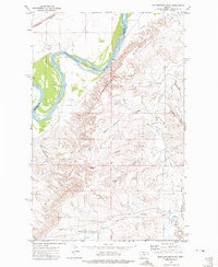 1972 Mortarstone Bluff1975 Print · USGSThe Missouri River breaks through the high plains of eastern Montana in the early 1970s, marking the edge of the Fort Peck Indian Reservation. Local researchers can trace the tracks of the Burlington Northern and find specific community sites like Riverside Ch and the Fisher Cem.2 unique versions available
 - 1972 Map of Badger Creek, 1975 Print
 1972 Badger Creek1975 Print · USGSRoosevelt County in the early seventies shows a landscape defined by the Poplar River and the expanding East Poplar Oil Field. Researchers can trace old resource extraction sites, from several Oil Wells to the Crandall Reservoir and the Little Badger Spr.
 - 1972 Map of Brockton, 1975 Print
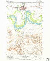
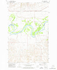
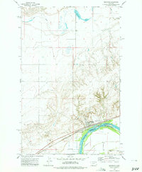 1972 Brockton1975 Print · USGSBrockton and the Missouri River corridor are captured here during the 1970s, showcasing the town's agricultural and rail infrastructure. Genealogists and local historians can locate specific landmarks like the Ruffatto Sch, Twomile Hall, and the town's original Rodeo Ground.2 unique versions available
 - 1972 Map of Sprole, 1976 Print
 1972 Sprole1976 Print · USGSThe Missouri River valley at the Roosevelt and Richland county line is captured here in the early 1970s. Trace the rural rail-and-river economy through landmarks like the Sprole Storage Bins, the Burlington Northern line, and White Shield Island.2 unique versions available
 - 1973 Map of Pleasant Prairie, 1976 Print
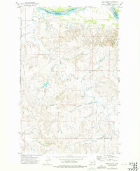
 1973 Pleasant Prairie1976 Print · USGSNortheastern Montana ranching country is captured here in the early 1970s within the Fort Peck Indian Reservation. Genealogists and local historians can trace the community around Pleasant Prairie Ch, the Cem, and the Westby School Center.
 - 1973 Map of Pleasant Prairie NW, 1976 Print
 1973 Pleasant Prairie NW1976 Print · USGSDaniels County is shown in the early seventies, capturing the sparsely populated prairie where the reservation meets the High Plains. Genealogists and local historians can locate Orville Cem and trace the paths of Smoke Creek and Eagle Creek.
 - 1973 Map of Pleasant Prairie SW, 1976 Print
 1973 Pleasant Prairie SW1976 Print · USGSRoosevelt and Daniels counties are shown during the 1970s, featuring the open prairie landscape of the Fort Peck Indian Reservation. Researchers can trace landforms like Square Butte, Pole Hill, and the course of Out Give Creek.
 - 1973 Map of Pleasant Prairie NE, 1977 Print
 1973 Pleasant Prairie NE1977 Print · USGSNortheast Montana at the beginning of the 1970s shows a landscape of wide-open ranching country and tribal lands. Researchers can locate the Fort Peck Indian Reservation Boundary, the community gathering point at Wolf Creek Hall, and several Storage Bins scattered near Eagle Creek.
End of results
Showing maps 1-11 of 11
Top cities near Brockton District
Top neighborhoods of Brockton District
- Anderson historical maps
- Biem historical maps
- Pleasant Prairie historical maps
- Sprole historical maps
- Brockton historical maps
Frequently asked questions
- What are the different types of historical maps available for Brockton District?
- What is the oldest map of Brockton District?
- Where can I purchase historical maps of Brockton District for my home or office?
- Where can I download high-res historical maps of Brockton District?
- Are there historical topographic maps available for Brockton District?
- Is there historical aerial imagery available for Brockton District?
- Where are historical maps of Brockton District sourced from?