1980s Maps of Brockton District, Montana
Explore 13 historic maps of Brockton District from the 1980s. These maps offer a rare glimpse into what life looked like during the 1980s — showing old roads, neighborhoods, homes, and landmarks that have changed or disappeared over time.
Whether you're researching your family's past, planning a metal detecting trip, or studying how Brockton District's landscape evolved across the 1980s, these high-resolution maps are a powerful tool for exploring the history of this region.
- Focus on a specific era: All maps on this page are from the 1980s, giving you a focused view of this time period.
- See what’s changed: Compare century-old streets, trails, and buildings to today's modern landscape using overlays and satellite layers.
- Research with precision: Use these maps for genealogy, historical research, land use analysis, or educational projects.
- View, download, or print: Maps are fully viewable online in high resolution, and can be downloaded or printed for your own records.
Start exploring Brockton District's history through authentic maps from the 1980s. This is your window into the past.
Brockton District, MT maps
(13)- 1982 Map of Culbertson, 1983 Print
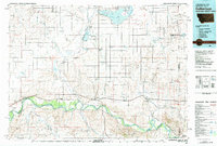 1982 Culbertson1983 Print · USGSNortheastern Montana at the start of the 1980s reveals a high-plains landscape defined by the Missouri River and the rail lines that served its valley. Genealogists and researchers can trace the townships surrounding Culbertson, Bainville, and the Fort Union Trading Post.
 - 1983 Map of Hay Creek NW
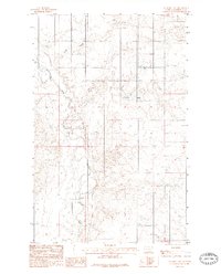
 1983 Hay Creek NW1983 Print · USGSThe Fort Peck Indian Reservation landscape in the early eighties is defined by the winding Poplar River and its many tributaries. Researchers can trace the drainage patterns and land contours of Roosevelt County through features like Swank Coulee and Lone Tree Creek.
 - 1983 Map of Smoke Creek SW
 1983 Smoke Creek SW1983 Print · USGSNortheastern Montana's high plains are captured here in the early eighties within the Fort Peck Indian Reservation. Local history researchers can trace the natural drainage of Lake Creek across the township lines of T30N and T29N.
 - 1983 Map of Long Creek East
 1983 Long Creek East1983 Print · USGSNortheastern Montana's high plains within the Fort Peck Indian Reservation are captured here as they appeared in the early eighties. Local historians and land researchers can trace the drainages of the Poplar River and find agricultural landmarks like Grain Bins.
 - 1983 Map of Geddart Lake
 1983 Geddart Lake1983 Print · USGSRoosevelt County's northern plains are captured here in the early eighties, centered on the winding Poplar River. Researchers can trace the path of a local Pipe Line and locate essential agricultural markers like Geddart Lake and Grain Bins.2 unique versions available
 - 1983 Map of Hay Creek
 1983 Hay Creek1983 Print · USGSThe high prairie of the Fort Peck Indian Reservation is shown in detail during the late twentieth century. Researchers can trace the drainage patterns across the Missouri River plateau through features like Hay Creek, Swank Coulee, and Kirns Coulee.
 - 1983 Map of Smoke Creek NE
 1983 Smoke Creek NE1983 Print · USGSNortheastern Montana is shown during the early 1980s in this detailed record of the Fort Peck Indian Reservation. Researchers can trace the winding path of Smoke Creek and locate Burshia Coulee in this quiet corner of Roosevelt Co.
 - 1983 Map of Soo NW
 1983 Soo NW1983 Print · USGSNortheastern Montana's high plains are captured here in the early 1980s, revealing the rural landscape near the Sheridan Co line. You can trace the Fort Peck Indian Reservation Boundary and the winding paths of Redstone Creek and Wolf Creek.
 - 1983 Map of Beam School
 1983 Beam School1983 Print · USGSIn the early eighties, this portion of Roosevelt County remained a landscape of isolated homesteads and prairie schools. Researchers can trace rural landmarks like Beam School and the meandering path of Smoke Creek through the Fort Peck Indian Reservation.
 - 1983 Map of Thornwood Ranch
 1983 Thornwood Ranch1983 Print · USGSNortheastern Montana ranching country is captured here in the early 1980s, showing the intersection of remote landscapes and high plains agriculture. Researchers can trace the drainage of Wolf Creek or locate the namesake Thornwood Ranch and Burshia Coulee.
 - 1983 Map of Soo NE
 1983 Soo NE1983 Print · USGSSheridan County's high prairie comes into focus in this late twentieth-century survey of the Soo NE region. Researchers can trace the Fort Peck Indian Reservation Boundary and the winding course of Wolf Creek.
 - 1983 Map of Soo
 1983 Soo1983 Print · USGSNortheastern Montana's high plains are documented here in the early 1980s at the junction of three counties. Genealogists and researchers can trace the roads near the settlement of Soo and follow the natural paths of Smoke Creek and Burshia Coulee.
 - 1983 Map of Scobey, 1984 Print
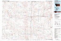 1983 Scobey1984 Print · USGSNorthern Montana prairie life during the early eighties centered on the grain-hauling rail lines and the winding Poplar River forks. Genealogists and historians can trace old homesteads near Whitetail, Peerless, and the Fort Peck Indian Reservation Boundary.
End of results
Showing maps 1-13 of 13
Top cities near Brockton District
Top neighborhoods of Brockton District
- Anderson historical maps
- Biem historical maps
- Pleasant Prairie historical maps
- Sprole historical maps
- Brockton historical maps
Frequently asked questions
- What are the different types of historical maps available for Brockton District?
- What is the oldest map of Brockton District?
- Where can I purchase historical maps of Brockton District for my home or office?
- Where can I download high-res historical maps of Brockton District?
- Are there historical topographic maps available for Brockton District?
- Is there historical aerial imagery available for Brockton District?
- Where are historical maps of Brockton District sourced from?