1960s Maps of Cherry County, Nebraska
Explore 4 historic maps of Cherry County from the 1960s. These maps offer a rare glimpse into what life looked like during the 1960s — showing old roads, neighborhoods, homes, and landmarks that have changed or disappeared over time.
Whether you're researching your family's past, planning a metal detecting trip, or studying how Cherry County's landscape evolved across the 1960s, these high-resolution maps are a powerful tool for exploring the history of this region.
- Focus on a specific era: All maps on this page are from the 1960s, giving you a focused view of this time period.
- See what’s changed: Compare century-old streets, trails, and buildings to today's modern landscape using overlays and satellite layers.
- Research with precision: Use these maps for genealogy, historical research, land use analysis, or educational projects.
- View, download, or print: Maps are fully viewable online in high resolution, and can be downloaded or printed for your own records.
Start exploring Cherry County's history through authentic maps from the 1960s. This is your window into the past.
Cherry County, NE maps
(4)- 1969 Map of Gordon SE, 1971 Print
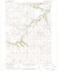
 1969 Gordon SE1971 Print · USGSRanching and rail life converge in Cherry County during the late sixties as the Chicago and North Western crosses the plains. Genealogists can locate rural schoolhouses like Sunny Knoll Sch and Northwest Cherry Sch among the breaks of Antelope Creek.
 - 1969 Map of Rushville 4 NE, 1972 Print
 1969 Rushville 4 NE1972 Print · USGSThe Niobrara River valley in the Nebraska Sandhills is captured here in the late sixties, showing a remote landscape of canyons and cattle country. Genealogists can locate the Lavaca Cem, Longview Sch, and historical river crossings like Hardin Bridge.2 unique versions available
 - 1969 Map of Hog Island, 1972 Print
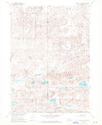
 1969 Hog Island1972 Print · USGSThe Nebraska Sandhills at the South Dakota border are captured here in the late sixties, showing the vast network of lakes and marshes south of the Pine Ridge Indian Reservation Boundary. Researchers can trace the unique hydrology of Hog Island, Shell Lake, and the winding Meadow Horseshoe Ditch.
 - 1969 Map of Rushville 4 SE, 1972 Print
 1969 Rushville 4 SE1972 Print · USGSThe Nebraska sandhills at the boundary of Sheridan and Cherry counties are defined here by the winding Snake River and its surrounding lake basins. Researchers can trace the rural landscape across Lavaca and Kinkaid, locating landmarks like Big Lake and Huckleberry Lake.2 unique versions available
End of results
Showing maps 1-4 of 4
Top cities of Cherry County
- Valentine historical maps
- Cody historical maps
- Merriman historical maps
- Kilgore historical maps
- Crookston historical maps
- Wood Lake historical maps
See more
Frequently asked questions
- What are the different types of historical maps available for Cherry County?
- What is the oldest map of Cherry County?
- Where can I purchase historical maps of Cherry County for my home or office?
- Where can I download high-res historical maps of Cherry County?
- Are there historical topographic maps available for Cherry County?
- Is there historical aerial imagery available for Cherry County?
- Where are historical maps of Cherry County sourced from?