1960s Maps of Dawson County, Nebraska
Explore 12 historic maps of Dawson County from the 1960s. These maps offer a rare glimpse into what life looked like during the 1960s — showing old roads, neighborhoods, homes, and landmarks that have changed or disappeared over time.
Whether you're researching your family's past, planning a metal detecting trip, or studying how Dawson County's landscape evolved across the 1960s, these high-resolution maps are a powerful tool for exploring the history of this region.
- Focus on a specific era: All maps on this page are from the 1960s, giving you a focused view of this time period.
- See what’s changed: Compare century-old streets, trails, and buildings to today's modern landscape using overlays and satellite layers.
- Research with precision: Use these maps for genealogy, historical research, land use analysis, or educational projects.
- View, download, or print: Maps are fully viewable online in high resolution, and can be downloaded or printed for your own records.
Start exploring Dawson County's history through authentic maps from the 1960s. This is your window into the past.
Dawson County, NE maps
(12)- 1961 Map of Elm Creek West, 1963 Print
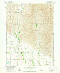
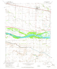
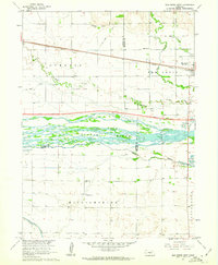 1961 Elm Creek West1963 Print · USGSCentral Nebraska's river valley and rail corridor are captured here in the early sixties, as the irrigation-fed landscape prepared for modern highway expansion. Genealogists can locate rural landmarks like Williamsburg Ch, East Twelfth Sch, and the small siding at Trued.
 - 1961 Map of Miller SW, 1963 Print
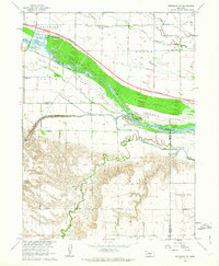
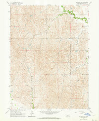
 1961 Miller SW1963 Print · USGSDawson and Buffalo counties are captured here in the early sixties, showing a rural Nebraska landscape shaped by the Missouri River Basin project. Genealogists can trace family footprints near Fairview Cem or the old grounds of School No 83 and School No 63.2 unique versions available
 - 1962 Map of Lexington West, 1964 Print
 1962 Lexington West1964 Print · USGSDawson County and the Platte River valley are shown in the early sixties as a hub of irrigation and rail transport. Genealogists and historians can trace the local landscape through rural landmarks like School No 38, the Emigrant Trail, and Grace Cem.2 unique versions available
 - 1962 Map of Lexington SE, 1964 Print
 1962 Lexington SE1964 Print · USGSDawson County agriculture and rural life are detailed here in the early sixties, showing the complex irrigation networks of the Nebraska plains. Genealogists and historians can trace the foundations of the community through landmarks like Fairhaven Ch, School No 21, and the Dawson County Canal.2 unique versions available
 - 1962 Map of Buffalo, 1964 Print
 1962 Buffalo1964 Print · USGSThe Dawson County plains in the early 1960s were a landscape of managed waterways and small-scale farming communities. Researchers can trace the irrigation network of the Gothenburg Canal and locate rural landmarks like Rose Hill Cem and School No 44.
 - 1962 Map of Miller, 1964 Print
 1962 Miller1964 Print · USGSMiller and the surrounding Buffalo County townships are captured in the early sixties as the Union Pacific railroad continues to shape local life. Genealogists and historians can locate family landmarks like the Armada Cem and trace the paths of Wood River and Cherry Valley Creek.
 - 1962 Map of Sumner, 1964 Print
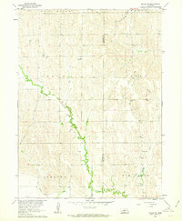
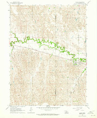
 1962 Sumner1964 Print · USGSSumner and the surrounding Dawson County prairie are captured here in the early 1960s, documenting a landscape tied to the river and rail. Researchers can locate family landmarks like St Patricks Cem, the Dixon Sch, and the winding path of the Wood River.
 - 1962 Map of Lexington East, 1964 Print
 1962 Lexington East1964 Print · USGSThe Platte River valley near Lexington comes into focus in the early sixties, showing a landscape defined by the Union Pacific and an intricate irrigation system. Genealogists can trace family roots at St Anns Cem or identify old schoolhouses like Horseshoe Bend Sch and School No 17 North.2 unique versions available
 - 1962 Map of Overton, 1964 Print
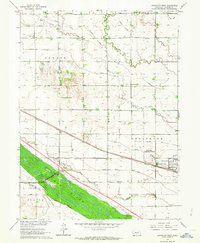
 1962 Overton1964 Print · USGSOverton and the Platte River valley are captured in the early sixties as a major new interstate highway was taking shape. Genealogists and local historians can trace rural roots at Overton Cem, Adullam Ch, and the site of West Twelfth Sch.2 unique versions available
 - 1962 Map of Bertrand NW, 1964 Print
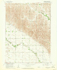
 1962 Bertrand NW1964 Print · USGSThe Platte River valley in the early sixties reveals a landscape in transition as the interstate highway began to carve through Nebraska's agricultural core. Genealogists can locate family-named landmarks like Robb Cem or trace early education at School No 3 and Spring Creek Sch.2 unique versions available
 - 1962 Map of Lexington NW, 1964 Print
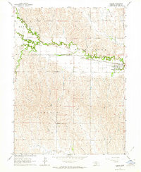
 1962 Lexington NW1964 Print · USGSDawson County in the early 1960s is defined by its rural townships and intricate irrigation networks. Genealogists and land historians can trace field boundaries and water rights along the Dawson Co Canal, Crooked Creek, and the township of Hillside.2 unique versions available
 - 1967 Map of North Platte
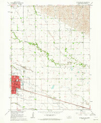
 1967 North Platte1967 Print · USGSThe Nebraska Sand Hills and the Platte River valley meet in the 1960s, showing a landscape shaped by water management and rail. Genealogists can trace rural school districts like the Prairie Dell School or find landmarks like the Scott Lookout Tower and Geo P Kingsley Dam.
End of results
Showing maps 1-12 of 12
Top cities of Dawson County
- Lexington historical maps
- Cozad historical maps
- Gothenburg historical maps
- Overton historical maps
- Sumner historical maps
- Farnam historical maps
See more
Frequently asked questions
- What are the different types of historical maps available for Dawson County?
- What is the oldest map of Dawson County?
- Where can I purchase historical maps of Dawson County for my home or office?
- Where can I download high-res historical maps of Dawson County?
- Are there historical topographic maps available for Dawson County?
- Is there historical aerial imagery available for Dawson County?
- Where are historical maps of Dawson County sourced from?