1940s Maps of Elko County, Nevada
Explore 7 historic maps of Elko County from the 1940s. These maps offer a rare glimpse into what life looked like during the 1940s — showing old roads, neighborhoods, homes, and landmarks that have changed or disappeared over time.
Whether you're researching your family's past, planning a metal detecting trip, or studying how Elko County's landscape evolved across the 1940s, these high-resolution maps are a powerful tool for exploring the history of this region.
- Focus on a specific era: All maps on this page are from the 1940s, giving you a focused view of this time period.
- See what’s changed: Compare century-old streets, trails, and buildings to today's modern landscape using overlays and satellite layers.
- Research with precision: Use these maps for genealogy, historical research, land use analysis, or educational projects.
- View, download, or print: Maps are fully viewable online in high resolution, and can be downloaded or printed for your own records.
Start exploring Elko County's history through authentic maps from the 1940s. This is your window into the past.
Elko County, NV maps
(7)- 1940 Map of Rowland
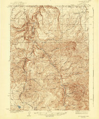 1940 Rowland1940 Print · USGSRemote ranching and high-desert terrain define this borderland region during the mid-1930s. Genealogists and researchers can trace family-named sites such as Budde Rizzi Ranch, the McKnight Cabin, and the community of Rowland.2 unique versions available
 - 1940 Map of Mountain City
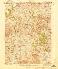 1940 Mountain City1940 Print · USGSElko County mining and ranching life are detailed in this survey of the Nevada-Idaho borderlands during the late thirties. Researchers can locate remote family operations like Rizzi Ranch and trace the local mining economy at the Rio Tinto Mine and Patsville.2 unique versions available
 - 1942 Map of Owyhee
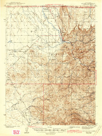 1942 Owyhee1942 Print · USGSThe high desert borderlands of Nevada and Idaho come alive in this pre-war survey of the Duck Valley Indian Reservation. Researchers can trace early irrigation systems and ranching landmarks like Lamb Reservoir, the Number One Settlement, and the Idaho-Nev Shaft mine.3 unique versions available
 - 1942 Map of Mt. Velma
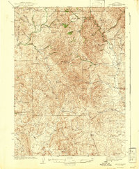 1942 Mt. Velma1942 Print · USGSElko County ranching and mining life are recorded here as they existed prior to the Second World War. Genealogists and historians can locate family holdings like the Guerricabeitia Ranch, the remote Bryan Sch, and McKnights Placer Mine.2 unique versions available
 - 1943 Map of Mineral Hill
 1943 Mineral Hill1943 Print · USGSCentral Nevada's mining and ranching corridor is documented here during the late 1930s as the rail era transitioned into memory. Researchers can trace the Nevada Eureka (Abandoned) rail line past Alpha Ranch and locate early sites like Mineral Hill and the Bell Mine.2 unique versions available
 - 1943 Map of Jarbidge, 1954 Print
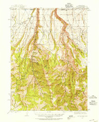 1943 Jarbidge1954 Print · USGSThe Jarbidge mining district in northern Elko County was still a remote outpost of industry and ranching in the 1940s. Genealogists and historians can trace the locations of the Altitude Mine, family operations at Larios Ranch, and the Mahoney Ranger Sta.3 unique versions available
 - 1945 Map of Jarbidge
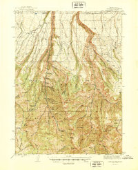 1945 Jarbidge1945 Print · USGSElko County, Nevada, during the mid-1940s reveals a high-country mining district centered on the town of Jarbidge. Researchers can trace the legacy of gold and silver extraction at the Success Mine or locate family-named sites like Larios Ranch.2 unique versions available
End of results
Showing maps 1-7 of 7
Top cities of Elko County
- Elko historical maps
- Spring Creek historical maps
- West Wendover historical maps
- Carlin historical maps
- Wells historical maps
- Owyhee historical maps
See more
Frequently asked questions
- What are the different types of historical maps available for Elko County?
- What is the oldest map of Elko County?
- Where can I purchase historical maps of Elko County for my home or office?
- Where can I download high-res historical maps of Elko County?
- Are there historical topographic maps available for Elko County?
- Is there historical aerial imagery available for Elko County?
- Where are historical maps of Elko County sourced from?