Old Maps of Elko County, Nevada for Academic Research
Study the evolution of Elko County with 752 high-resolution historic maps. Whether you're teaching, researching, or modeling changes in land use, these maps provide essential visual documentation of urban, environmental, and geographic change.
- Analyze long-term change: Track patterns in development, transportation, and natural features.
- Ideal for environmental or urban studies: Support academic projects with primary historical map data.
- Use in the classroom or lab: Educators and researchers rely on these maps to bring historical context to life.
These maps are a powerful tool for teaching, research, and visualizing how Elko County has changed over the decades.
Elko County, NV maps
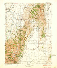
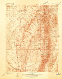
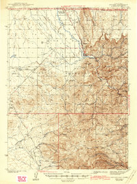
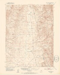
(752)- 1882 Map of Paradise
 1882 Paradise1882 Print · USGSHumboldt County in the early 1880s remains a frontier landscape of isolated stage stations and high mountain peaks. Genealogists and researchers can trace the early transit network between Paradise City and remote stops like Cane Springs Station and Flynn Station.
 - 1893 Map of Paradise
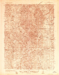
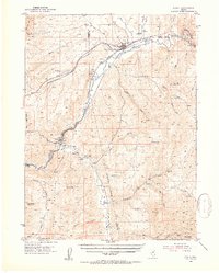
 1893 Paradise1893 Print · USGSHumboldt County was a landscape of remote outposts and high-desert ranges in the late nineteenth century. Researchers can trace the early stage and freight routes connecting Paradise City to vital waystations such as Cane Springs Station and Willow Point Station.6 unique versions available
 - 1934 Map of Jiggs, 1955 Print
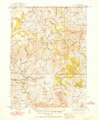
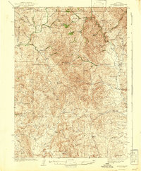
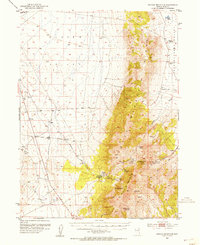
 1934 Jiggs1955 Print · USGSElko County ranching life in the 1930s is preserved here, centered on the small hub of Jiggs and the high peaks of the Ruby Mountains. Researchers can locate dozens of family-named sites, from Zunino Ranch to the Davis Ranch Hobson Post Office and the remote Johnson Cabin.
 - 1935 Map of Halleck
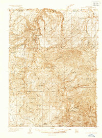
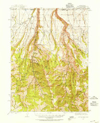
 1935 Halleck1935 Print · USGSElko County cattle country and high mountain basins are captured here during the mid-thirties, showing the transition from frontier outposts to a ranching economy. Genealogists can trace family holdings like the Starr Ranch or locate the site of Fort Halleck and various rural schoolhouses.3 unique versions available
 - 1935 Map of Charleston
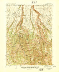
 1935 Charleston1935 Print · USGSElko County ranching and mining country comes alive in this mid-1930s survey of the high Nevada desert. Genealogists and historians can trace family homesteads like Mendive Ranch and Guerrricabita Ranch, or locate old operations such as Mc Knights Placer Mine.5 unique versions available
 - 1936 Map of Mountain City
 1936 Mountain City1936 Print · USGSElko County and the borderlands of Idaho are captured during the 1930s as mining and ranching shaped this high-desert region. Researchers can trace historic family properties like McKenzie Ranch or locate industrial sites such as the Rio Tinto Mine and the Allegheny Sch.4 unique versions available
 - 1936 Map of Rowland
 1936 Rowland1936 Print · USGSThe Nevada-Idaho borderlands come to life in the mid-1930s as a landscape of remote ranching and mining outposts. Trace the family legacies of the Hagenbuch Ranch and Palacio Ranch near the Bruneau Mine and Rowland PO.4 unique versions available
 - 1937 Map of Mineral Hill
 1937 Mineral Hill1937 Print · USGSEureka County mining and ranching operations are documented here in the late 1930s as the Eureka Nevada RR served the high desert. Researchers can trace historic family-named sites like Bruffey Ranch and the workings at the Old Whalen Mine.4 unique versions available
 - 1937 Map of Jiggs
 1937 Jiggs1937 Print · USGSElko County ranching life is preserved here during the 1930s, when isolated family homesteads were the primary anchors of the high desert landscape. Genealogists and historians can trace the locations of the Davis Ranch Hobson PO, the Smith Creek Sch, and the Harrison Pass Ranger Sta.2 unique versions available
 - 1939 Map of Owyhee, 1965 Print
 1939 Owyhee1965 Print · USGSThe Nevada-Idaho borderlands come into focus in the late 1930s, centered on the Duck Valley Indian Reservation and the vital Owyhee River. Researchers can trace early irrigation works like China Dam and find vanished points of interest such as Number One Settlement and the Idaho-Nev Shaft.
 - 1940 Map of Rowland
 1940 Rowland1940 Print · USGSRemote ranching and high-desert terrain define this borderland region during the mid-1930s. Genealogists and researchers can trace family-named sites such as Budde Rizzi Ranch, the McKnight Cabin, and the community of Rowland.2 unique versions available
 - 1940 Map of Mountain City
 1940 Mountain City1940 Print · USGSElko County mining and ranching life are detailed in this survey of the Nevada-Idaho borderlands during the late thirties. Researchers can locate remote family operations like Rizzi Ranch and trace the local mining economy at the Rio Tinto Mine and Patsville.2 unique versions available
 - 1942 Map of Owyhee
 1942 Owyhee1942 Print · USGSThe high desert borderlands of Nevada and Idaho come alive in this pre-war survey of the Duck Valley Indian Reservation. Researchers can trace early irrigation systems and ranching landmarks like Lamb Reservoir, the Number One Settlement, and the Idaho-Nev Shaft mine.3 unique versions available
 - 1942 Map of Mt. Velma
 1942 Mt. Velma1942 Print · USGSElko County ranching and mining life are recorded here as they existed prior to the Second World War. Genealogists and historians can locate family holdings like the Guerricabeitia Ranch, the remote Bryan Sch, and McKnights Placer Mine.2 unique versions available
 - 1943 Map of Mineral Hill
 1943 Mineral Hill1943 Print · USGSCentral Nevada's mining and ranching corridor is documented here during the late 1930s as the rail era transitioned into memory. Researchers can trace the Nevada Eureka (Abandoned) rail line past Alpha Ranch and locate early sites like Mineral Hill and the Bell Mine.2 unique versions available
 - 1943 Map of Jarbidge, 1954 Print
 1943 Jarbidge1954 Print · USGSThe Jarbidge mining district in northern Elko County was still a remote outpost of industry and ranching in the 1940s. Genealogists and historians can trace the locations of the Altitude Mine, family operations at Larios Ranch, and the Mahoney Ranger Sta.3 unique versions available
 - 1945 Map of Jarbidge
 1945 Jarbidge1945 Print · USGSElko County, Nevada, during the mid-1940s reveals a high-country mining district centered on the town of Jarbidge. Researchers can trace the legacy of gold and silver extraction at the Success Mine or locate family-named sites like Larios Ranch.2 unique versions available
 - 1952 Map of Dixie Flats, 1954 Print
 1952 Dixie Flats1954 Print · USGSNorthern Nevada ranching and rail activity are captured here in the early fifties, where the Southern Pacific meets the desert. Genealogists can trace early homesteads like Tomera Ranch and the haunting Site of Old Bullion.4 unique versions available
 - 1952 Map of Pine Valley, 1954 Print
 1952 Pine Valley1954 Print · USGSPine Valley and the surrounding mountains are documented here in the early fifties, showing the high-desert ranching life of the Great Basin. Genealogists and historians can trace family properties like Slagowski Ranch or locate the Indian Campground and Dismantled Railroad.4 unique versions available
 - 1952 Map of Carlin, 1954 Print
 1952 Carlin1954 Print · USGSThe Nevada high desert meets the iron rail in the early 1950s as the Southern Pacific and Western Pacific navigate the Humboldt River corridor. Researchers can trace historic routes like the California Trail or locate family sites like Raine Ranch and Thomas Place.5 unique versions available
 - 1953 Map of Spruce Mountain, 1955 Print
 1953 Spruce Mountain1955 Print · USGSIn the high basins of Elko County during the early fifties, the mining and ranching legacy of the Great Basin is clearly etched. Trace the mineral operations of the Monarch Mine and Black Forest Mine, or locate the historic settlement at Sprucemont and seasonal outposts like Sheep Camp.4 unique versions available
 - 1953 Map of Spruce Mountain 4, 1955 Print
 1953 Spruce Mountain 41955 Print · USGSElko County was a high-desert crossroads in the early fifties, where vital rail lines navigated the rugged gaps between mountain ranges. Researchers can trace the paths of the Western Pacific and Nevada Northern railroads past Hogan and Dolly Varden.4 unique versions available
 - 1955 Map of McDermitt
 1955 McDermitt1955 Print · USGSNorthern Nevada in the mid-fifties shows a landscape of mining camps and vast cattle ranges. Trace the early footprints of Tuscarora or the remote Cordero Mine and National Mine tucked into the high desert peaks.3 unique versions available
 - 1955 Map of Wells, 1966 Print
 1955 Wells1966 Print · USGSNortheastern Nevada's high basin-and-range country is documented here in the mid-fifties, showing a landscape of remote ranching outposts and massive federal forest lands. Researchers can locate the early mining districts at Delano Mines and trace the paths of the Southern Pacific railroad through settlements like Deeth and Cobre.4 unique versions available
 - 1955 Map of Winnemucca, 1968 Print
 1955 Winnemucca1968 Print · USGSNorthern Nevada's high desert corridor is captured here in the mid-fifties, centered on the river-and-rail hub of Winnemucca. Researchers can trace the dual tracks of the Southern Pacific and Western Pacific railroads through towns like Golconda and Valmy.3 unique versions available
Showing maps 1-25 of 752
Top cities of Elko County
- Elko historical maps
- Spring Creek historical maps
- West Wendover historical maps
- Carlin historical maps
- Wells historical maps
- Owyhee historical maps
See more
Frequently asked questions
- What are the different types of historical maps available for Elko County?
- What is the oldest map of Elko County?
- Where can I purchase historical maps of Elko County for my home or office?
- Where can I download high-res historical maps of Elko County?
- Are there historical topographic maps available for Elko County?
- Is there historical aerial imagery available for Elko County?
- Where are historical maps of Elko County sourced from?