1990s Maps of Elko County, Nevada
Explore 8 historic maps of Elko County from the 1990s. These maps offer a rare glimpse into what life looked like during the 1990s — showing old roads, neighborhoods, homes, and landmarks that have changed or disappeared over time.
Whether you're researching your family's past, planning a metal detecting trip, or studying how Elko County's landscape evolved across the 1990s, these high-resolution maps are a powerful tool for exploring the history of this region.
- Focus on a specific era: All maps on this page are from the 1990s, giving you a focused view of this time period.
- See what’s changed: Compare century-old streets, trails, and buildings to today's modern landscape using overlays and satellite layers.
- Research with precision: Use these maps for genealogy, historical research, land use analysis, or educational projects.
- View, download, or print: Maps are fully viewable online in high resolution, and can be downloaded or printed for your own records.
Start exploring Elko County's history through authentic maps from the 1990s. This is your window into the past.
Elko County, NV maps
(8)- 1990 Map of Lamoille
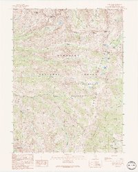
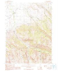 1990 Lamoille1990 Print · USGSLamoille sits at the base of the high mountain ranges during the late twentieth century, where the valley floor meets the canyon mouths. Researchers can trace local landmarks like the Cemetery, the old Power House, and seasonal sites such as Camp Lamoille.2 unique versions available
 - 1990 Map of Ruby Valley School, 1991 Print
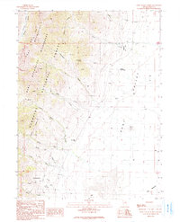 1990 Ruby Valley School1991 Print · USGSElko County, Nevada, at the start of the 1990s reveals a landscape of high wilderness and high-desert ranching. Researchers can locate the Ruby Valley Sch and local Cem, or trace early mining efforts at several Prospects and a named Adit.
 - 1990 Map of West of Lee, 1991 Print
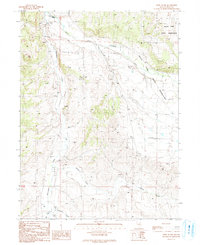 1990 West of Lee1991 Print · USGSElko County, Nevada, in the early nineties shows a landscape of high desert ranching and tribal lands. Genealogists and researchers can trace water sources and land use through South Fork Indian Reservation, Twin Bridges, and Huntington Creek.
 - 1990 Map of Noon Rock, 1991 Print
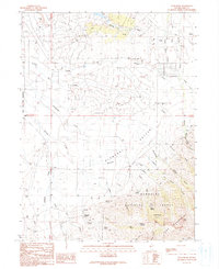 1990 Noon Rock1991 Print · USGSThe foothills of the Ruby Mountains meet Pleasant Valley in the 1980s, revealing a landscape of managed water and small ranching outposts. Researchers can trace land use through the AQUEDUCT, Dry Farm, and named locations like Brennen and Peterson.
 - 1990 Map of Ruby Dome, 1991 Print
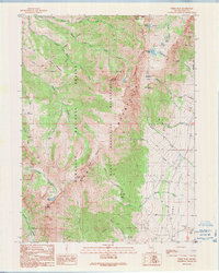
 1990 Ruby Dome1991 Print · USGSHigh in the Nevada wilderness during the early nineties, this survey captures a landscape defined by steep peaks and mining interests. Trace the history of mineral extraction at the American Beauty Mine or explore the alpine basins around Island Lake and Lamoille Lake.2 unique versions available
 - 1990 Map of Te-Moak Well, 1991 Print
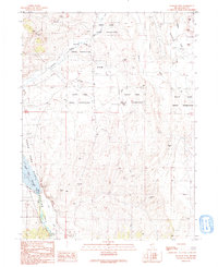 1990 Te-Moak Well1991 Print · USGSElko County ranching and reservation lands meet the evolving shoreline of the South Fork Reservoir in the late twentieth century. Researchers can trace the development of the South Fork Indian Reservation and locate remote landmarks like Te-Moak Well and Tenmile Well.
 - 1990 Map of Lee, 1991 Print
 1990 Lee1991 Print · USGSElko County’s high-desert valley and mountain slopes are captured here in the early nineties, centered on the South Fork Indian Reservation. Genealogists and historians can trace the settlement at Lee and follow high-altitude routes through Echo Canyon and along the South Fork Humboldt River.
 - 1991 Map of Verdi Peak
 1991 Verdi Peak1991 Print · USGSHigh in the Ruby Mountains during the early nineties, this survey captures the transition from wilderness peaks to the grazing lands of the Ruby Valley. Researchers can trace land features like Verdi Lake, find the small Cem near the valley edge, or locate Joe Billy Basin.
End of results
Showing maps 1-8 of 8
Top cities of Elko County
- Elko historical maps
- Spring Creek historical maps
- West Wendover historical maps
- Carlin historical maps
- Wells historical maps
- Owyhee historical maps
See more
Frequently asked questions
- What are the different types of historical maps available for Elko County?
- What is the oldest map of Elko County?
- Where can I purchase historical maps of Elko County for my home or office?
- Where can I download high-res historical maps of Elko County?
- Are there historical topographic maps available for Elko County?
- Is there historical aerial imagery available for Elko County?
- Where are historical maps of Elko County sourced from?