1920s Maps of Hidalgo County, New Mexico
Explore 6 historic maps of Hidalgo County from the 1920s. These maps offer a rare glimpse into what life looked like during the 1920s — showing old roads, neighborhoods, homes, and landmarks that have changed or disappeared over time.
Whether you're researching your family's past, planning a metal detecting trip, or studying how Hidalgo County's landscape evolved across the 1920s, these high-resolution maps are a powerful tool for exploring the history of this region.
- Focus on a specific era: All maps on this page are from the 1920s, giving you a focused view of this time period.
- See what’s changed: Compare century-old streets, trails, and buildings to today's modern landscape using overlays and satellite layers.
- Research with precision: Use these maps for genealogy, historical research, land use analysis, or educational projects.
- View, download, or print: Maps are fully viewable online in high resolution, and can be downloaded or printed for your own records.
Start exploring Hidalgo County's history through authentic maps from the 1920s. This is your window into the past.
Hidalgo County, NM maps
(6)- 1920 Map of Animas Peak
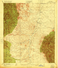 1920 Animas Peak1920 Print · USGSSouthern New Mexico ranching culture is preserved in this post-war survey of the Hidalgo County borderlands. Researchers can trace the heritage of local homesteads like the Gray Ranch, Old Isaacs Place, and the remote Maddox School.2 unique versions available
 - 1922 Map of McDonald, 1928 Print
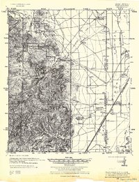
 1922 McDonald1928 Print · USGSThe Arizona and New Mexico borderlands meet the international boundary in the 1920s, showing a landscape defined by cattle ranching and desert springs. Researchers can trace historic family holdings like Hazelwood Ranch and remote landmarks such as the Cottonwood Creek School and Spring of Contention.
 - 1923 Map of Walnut Wells
 1923 Walnut Wells1923 Print · USGSHidalgo County's remote desert ranges and ranching outposts are captured here during the early statehood years. Genealogists and historians can trace family-named lands like Lawhorns Ranch and Godfrey Ranch or locate the site of the Red Hill Mine.
 - 1926 Map of Rodeo
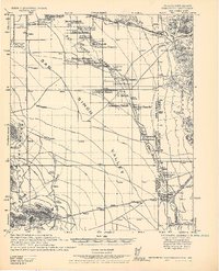
 1926 Rodeo1926 Print · USGSThe high desert borderlands near the Arizona state line thrived with cattle ranching and mining during the mid-twenties. Genealogists and historians can locate family landmarks like Hall Ranch, the Lone Oak School, and the Washburn Mining Co.
 - 1926 Map of Orange Butte
 1926 Orange Butte1926 Print · USGSCochise County's desert frontier comes into sharp focus during the mid-twenties, tracing the borderlands from the Peloncillo Mountains to the Animas Valley. Researchers can locate dozens of family-named landmarks like Lyall Ranch and Chamberlin Ranch, alongside working claims at Volcano Mine.
 - 1928 Map of Chenoweth
 1928 Chenoweth1928 Print · USGSCochise County ranching and mining operations are meticulously documented in the late 1920s as the borderlands modernised. Trace family homesteads like Metzger Ranch and Scovell Ranch or follow the Southern Pacific line to the Mineral Mtn Mine.
End of results
Showing maps 1-6 of 6
Top cities of Hidalgo County
Frequently asked questions
- What are the different types of historical maps available for Hidalgo County?
- What is the oldest map of Hidalgo County?
- Where can I purchase historical maps of Hidalgo County for my home or office?
- Where can I download high-res historical maps of Hidalgo County?
- Are there historical topographic maps available for Hidalgo County?
- Is there historical aerial imagery available for Hidalgo County?
- Where are historical maps of Hidalgo County sourced from?