1940s Maps of Otero County, New Mexico
Explore 36 historic maps of Otero County from the 1940s. These maps offer a rare glimpse into what life looked like during the 1940s — showing old roads, neighborhoods, homes, and landmarks that have changed or disappeared over time.
Whether you're researching your family's past, planning a metal detecting trip, or studying how Otero County's landscape evolved across the 1940s, these high-resolution maps are a powerful tool for exploring the history of this region.
- Focus on a specific era: All maps on this page are from the 1940s, giving you a focused view of this time period.
- See what’s changed: Compare century-old streets, trails, and buildings to today's modern landscape using overlays and satellite layers.
- Research with precision: Use these maps for genealogy, historical research, land use analysis, or educational projects.
- View, download, or print: Maps are fully viewable online in high resolution, and can be downloaded or printed for your own records.
Start exploring Otero County's history through authentic maps from the 1940s. This is your window into the past.
Otero County, NM maps
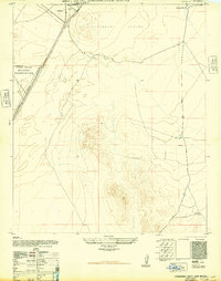
(36)- 1940 Map of El Paso Gap
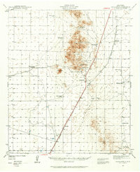
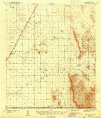
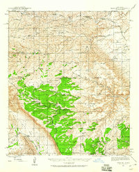
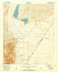
 1940 El Paso Gap1940 Print · USGSThe Guadalupe Mountains of southern New Mexico are shown in the mid-1930s, defined by a network of remote livestock ranches and isolated mountain schools. Genealogists and historians can trace family landholdings at Hepler Ranch or Lewis Ranch and locate vanished local landmarks like Queen Sch and the Old Post Place.3 unique versions available
 - 1940 Map of Bassett Lake, 1954 Print
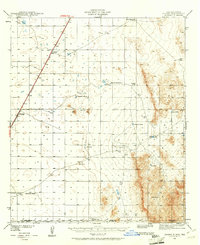
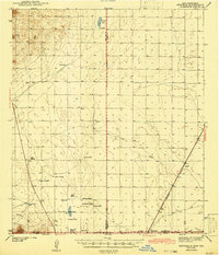
 1940 Bassett Lake1954 Print · USGSThe high desert of Otero County at the start of the 1940s reveals a landscape organized around vital water sources and remote ranching outposts. Researchers can trace the network of desert storage like Camaleche Tanks and Escondida Tank or locate the site of Foster Ranch.
 - 1940 Map of Orogrande, 1962 Print
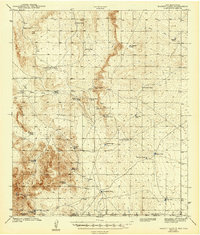
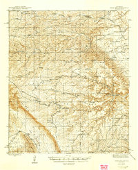
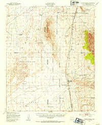
 1940 Orogrande1962 Print · USGSThe Tularosa Valley and Jarilla Mountains are seen here as they appeared in 1940, during a period of active desert mining and ranching. Genealogists and historians can trace family operations at McNew Ranch and McGregor Ranch or locate old workings at the Iron Queen Mine and Nannie Beard Mine.
 - 1940 Map of Newman, 1965 Print
 1940 Newman1965 Print · USGSThe high desert borderlands near the New Mexico-Texas line come alive in the 1940s, showing a landscape of remote cattle operations and vital rail links. Trace family history through ranch sites like Trueblood Ranch, locate the old Blythe Sch, and follow the Southern Pacific tracks to Newman.
 - 1941 Map of Desert, 1961 Print
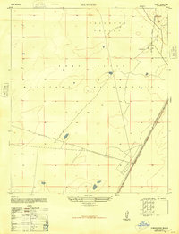
 1941 Desert1961 Print · USGSThe arid borderlands of Otero County and the New Mexico-Texas line are captured here in the early 1940s, when the railroad was the primary artery of life. Genealogists and historians can trace old ranching outposts like McCracken Ranch and Davis Ranch along the Southern Pacific tracks.2 unique versions available
 - 1943 Map of Parker Lake
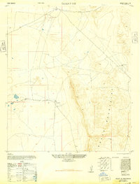
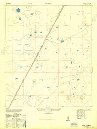
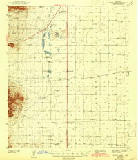 1943 Parker Lake1943 Print · USGSThe Tularosa Valley and San Andres Mountains appear here in the early 1940s, revealing a landscape defined by desert ranching and essential water sources. Genealogists and researchers can trace the locations of the Hat Ranch, Globe Spring Ranch, and numerous historic water features like Parker Well.2 unique versions available
 - 1943 Map of Pendejo Wash
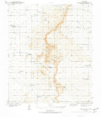 1943 Pendejo Wash1943 Print · USGSOtero County ranch lands are documented here during the early 1940s, showing a landscape defined by desert water management. Genealogists and historians can trace family-named sites like the Old Wright Place and vital water sources such as Wilde Well and Hay Meadow Tank.2 unique versions available
 - 1943 Map of Desert
 1943 Desert1943 Print · USGSOtero County ranching and rail operations are captured here during the early years of the war. Genealogists and historians can trace family landmarks and water sources like the McCracken Ranch, Davis Ranch, and the isolated Desert station along the Southern Pacific.
 - 1943 Map of Newman
 1943 Newman1943 Print · USGSThe high desert of the New Mexico and Texas borderlands comes alive in this wartime survey of the ranching country north of El Paso. Genealogists can trace the remote family outposts of the day, including Trueblood Ranch and Manning Ranch, and the isolated Blythe Sch.2 unique versions available
 - 1943 Map of Bassett Lake
 1943 Bassett Lake1943 Print · USGSThe arid high desert of Otero County and the Texas border are captured here during the early war years. Genealogists and desert historians can trace early ranching sites like Foster Ranch and numerous family-named landmarks including John Key Tank and Roberts Tank.
 - 1943 Map of Orogrande
 1943 Orogrande1943 Print · USGSOrogrande and the surrounding Tularosa Valley are shown at the height of the early 1940s mining and ranching era. Researchers can trace family-named sites like McNew Ranch or locate historical workings such as the Iron Queen Mine and Alice Mine.
 - 1943 Map of Texas Hill, 1960 Print
 1943 Texas Hill1960 Print · USGSThe high desert of Otero and Eddy counties is captured here in the mid-1940s, showcasing the isolated ranching life of the Guadalupe Mountains. Researchers can trace historic property boundaries and vital water sources like Hardin Ranch, A L Ranch, and Bates Windmill.2 unique versions available
 - 1945 Map of Texas Hill
 1945 Texas Hill1945 Print · USGSOtero County ranching culture is well-preserved here in the mid-1940s, showing a landscape defined by cattle operations and forest management. Researchers can trace historic family holdings like Hardin Ranch and A L Ranch or locate isolated structures such as Powers Shack.2 unique versions available
 - 1947 Map of Desert NE
 1947 Desert NE1947 Print · USGSThe northern Hueco Mountains and the arid ranchlands of Otero County are captured here in the late 1940s. Researchers can trace early water management and ranch life through features like Alvarado Tank No 2, South Well, and a local Windmill near the Hueco Mountains.
 - 1947 Map of Orogrande North, 1948 Print
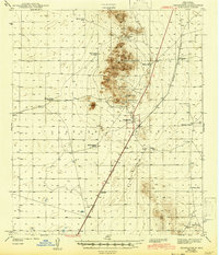
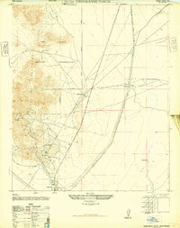 1947 Orogrande North1948 Print · USGSMining and military interests converge in the Tularosa Basin just after the war. Researchers can trace the rail-and-mine economy through the Southern Pacific line and sites like the Nannie Beard Mine, Iron Queen Mine, and the settlement of Orogrande.
 - 1947 Map of Point Of Sands 2, 1954 Print
 1947 Point Of Sands 21954 Print · USGSThe Tularosa Basin in the late 1940s reveals a transition from ranching lands to a high-tech military testing range. Researchers can locate remote sites like Andrecito alongside early aerospace landmarks like Landing Strip No 1 and Lake Lucero.
 - 1947 Map of Lake Lucero, 1954 Print
 1947 Lake Lucero1954 Print · USGSThe Tularosa Basin in the late 1940s reveals a unique intersection of traditional ranching and the emerging Cold War military infrastructure. Genealogists and historians can trace isolated homesteads like Lucero Ranch and Baird Ranch near the expansive White Sands National Monument.
 - 1947 Map of Three Rivers, 1954 Print
 1947 Three Rivers1954 Print · USGSThe Southern Pacific railroad and early military proving grounds define this Otero County landscape in the late forties. Trace family holdings like Falls Ranch and Hatchet Ranch alongside rail stops at Oscura and North Siding.2 unique versions available
 - 1947 Map of Capitol Peak, 1955 Print
 1947 Capitol Peak1955 Print · USGSThe northern reaches of the San Andres Mountains appear at the dawn of the atomic age, as the White Sands Proving Ground was being established. Researchers can trace remote water sources like Malpais Spring and the complex terrain of the Lava Bed and Mockingbird Gap.
 - 1948 Map of Davies Tank
 1948 Davies Tank1948 Print · USGSThe high desert of Doña Ana County appears here just after the war, showing the early infrastructure of the Fort Bliss Military Reservation. You can trace ranching history at Globe Spring Ranch or locate aviation landmarks like Condron Air Field.
 - 1948 Map of El Wood
 1948 El Wood1948 Print · USGSThe Tularosa Valley was undergoing a major transition in the late 1940s as ranchlands were absorbed into defense zones. Researchers can trace the Southern Pacific tracks past Elwood and locate local landmarks like McNew South Tank.
 - 1948 Map of Newman NW
 1948 Newman NW1948 Print · USGSIn the desert north of the border just after the war, this military landscape is defined by its strategic terrain and scattered water sources. Researchers can trace the early boundaries of the Fort Bliss Military Reservation and locate landmarks like Old Coe Lake and the Abandoned Road.
 - 1948 Map of Desert
 1948 Desert1948 Print · USGSThe Tularosa Valley in the late 1940s was a landscape of military expansion and railway transit. Researchers can trace the path of the Southern Pacific railroad through Fort Bliss Military Reservation and find old stops at Desert and Alvarado.
 - 1948 Map of Orogrande South
 1948 Orogrande South1948 Print · USGSThe Tularosa Valley in the years following the war reveals a landscape of high-desert ranching and military expansion. Genealogists and historians can trace the Southern Pacific line near Orogrande or locate the remote McGregor Ranch.
 - 1948 Map of Parker Lake SE
 1948 Parker Lake SE1948 Print · USGSIn the Tularosa Valley during the late 1940s, this area was defined by its role as a strategic military outpost. Researchers can trace the early road network across the Fort Bliss Military Reservation and the remote terrain of the Tularosa Valley.
Showing maps 1-25 of 36
Top cities of Otero County
- Alamogordo historical maps
- Tularosa historical maps
- Boles Acres historical maps
- Alamorosa historical maps
- High Rolls historical maps
- Cloudcroft historical maps
See more
Frequently asked questions
- What are the different types of historical maps available for Otero County?
- What is the oldest map of Otero County?
- Where can I purchase historical maps of Otero County for my home or office?
- Where can I download high-res historical maps of Otero County?
- Are there historical topographic maps available for Otero County?
- Is there historical aerial imagery available for Otero County?
- Where are historical maps of Otero County sourced from?