1960s Maps of Quay County, New Mexico
Explore 43 historic maps of Quay County from the 1960s. These maps offer a rare glimpse into what life looked like during the 1960s — showing old roads, neighborhoods, homes, and landmarks that have changed or disappeared over time.
Whether you're researching your family's past, planning a metal detecting trip, or studying how Quay County's landscape evolved across the 1960s, these high-resolution maps are a powerful tool for exploring the history of this region.
- Focus on a specific era: All maps on this page are from the 1960s, giving you a focused view of this time period.
- See what’s changed: Compare century-old streets, trails, and buildings to today's modern landscape using overlays and satellite layers.
- Research with precision: Use these maps for genealogy, historical research, land use analysis, or educational projects.
- View, download, or print: Maps are fully viewable online in high resolution, and can be downloaded or printed for your own records.
Start exploring Quay County's history through authentic maps from the 1960s. This is your window into the past.
Quay County, NM maps
(43)- 1962 Map of Logan, 1966 Print
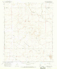
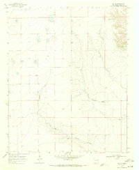
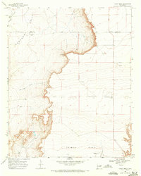
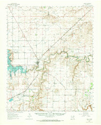 1962 Logan1966 Print · USGSQuay County ranching and rail life are documented here in the early sixties, centered on the Logan river crossing. Researchers can trace historic family holdings like Pyle Ranch and Martinez Springs or locate the Anniston Cem near the southern plains.
 - 1964 Map of Muniz Canyon, 1966 Print
 1964 Muniz Canyon1966 Print · USGSSan Miguel County ranchlands are captured here in the mid-1960s, showing a landscape defined by mesa edges and water infrastructure. Researchers can locate named family landmarks and stock tanks including Smith Windmill, Muniz Tank, and the Mesa Rica Camp.
 - 1964 Map of Gate Canyon, 1967 Print
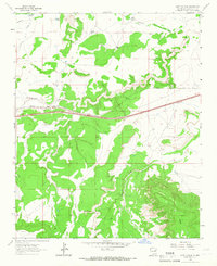 1964 Gate Canyon1967 Print · USGSGuadalupe County ranching and rail transport are captured here in the mid-1960s as the high desert landscape undergoes modernization. Researchers can locate remote family landmarks like Knowles Windmill, the Roman Camp settlement, and the old Chicago Rock Island and Pacific rail line.
 - 1964 Map of Montoya, 1967 Print
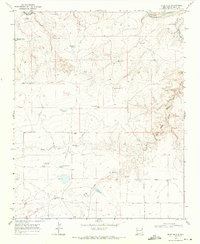
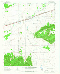 1964 Montoya1967 Print · USGSEastern New Mexico ranching and railroading are captured here in the mid-1960s as the modern interstate began to parallel old Route 66. Genealogists can trace family landmarks like Juana de Darca Ch or cattle operations centered at Headquarters Windmill and Registered Windmill.
 - 1964 Map of Ortega Tank, 1967 Print
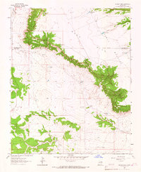 1964 Ortega Tank1967 Print · USGSGuadalupe and San Miguel counties appear here in the mid-1960s, showing a landscape of high mesas and cattle ranching infrastructure. Trace family names and historic land use through sites like Mitchell Windmill, Padilla Tank, and the Benavidez Windmills.
 - 1966 Map of Cherokee Valley, 1969 Print
 1966 Cherokee Valley1969 Print · USGSQuay County ranching and water management are frozen in time on this mid-century survey of the New Mexico high plains. Family researchers can locate early homesteads like Kaufman Ranch or trace the Cherokee Valley Cemetery and numerous family-named landmarks.
 - 1966 Map of Lockney, 1969 Print
 1966 Lockney1969 Print · USGSQuay County ranching country is captured here in the mid-1960s, showing a landscape defined by isolated wells and desert draws. Genealogists and local historians can locate specific family-named landmarks like Willis Well, Keyes Well, and the Lockney (Site).
 - 1966 Map of Mc Carty Ranch, 1969 Print
 1966 Mc Carty Ranch1969 Print · USGSThe high plains of the Harding and Quay county border are captured here in the mid-1960s, showing a landscape defined by ranching and water. Genealogists and local historians can trace family-named landmarks like Tom Young Well, Casados Well, and the McCarty Ranch.
 - 1966 Map of Mc Cloy Ranch, 1969 Print
 1966 Mc Cloy Ranch1969 Print · USGSHarding and Quay counties are depicted in the mid-1960s as a specialized landscape of cattle ranching and water management. Researchers can trace historic water sources and property boundaries through labels like the Old Church Well, McCloy Ranch, and Whorial Blanca Well.2 unique versions available
 - 1967 Map of Trinchera Creek, 1971 Print
 1967 Trinchera Creek1971 Print · USGSSan Miguel County ranch lands and the winding Canadian River are documented here in the late sixties. Researchers can trace land grant boundaries and vital water sources like the Chappell-Spade Ranch, the Old Railroad Grade, and Trinchera Well.
 - 1967 Map of Liberty Mesa, 1971 Print
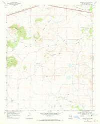
 1967 Liberty Mesa1971 Print · USGSQuay County ranching and rail infrastructure are on full display during the late sixties, showing the vital irrigation networks north of Tucumcari. Genealogists and historians can trace family landmarks like the Leslie Windmill or local sites such as the Drive-in Theater and Liberty.
 - 1967 Map of Tucumcari, 1971 Print
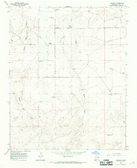
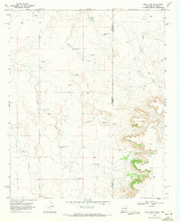
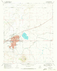 1967 Tucumcari1971 Print · USGSTucumcari was a vital rail and ranching center in the late sixties, where the high plains meet essential irrigation networks. Researchers can trace the development of the city's schools and neighborhoods near landmarks like Tucumcari Mountain and Tucumcari Lake.
 - 1968 Map of Hassell, 1971 Print
 1968 Hassell1971 Print · USGSQuay County ranching country is captured here in the late sixties, showing the isolated homesteads and burial grounds of the High Plains. Researchers can locate family landmarks like Urton Ranch and the small Lone Mesa Cem or Gerhardt Cem.
 - 1968 Map of Twin Mesa NW, 1971 Print
 1968 Twin Mesa NW1971 Print · USGSDe Baca and Quay counties are captured here in the late sixties, showcasing a landscape shaped by high-desert ranching. Researchers can locate family landmarks like Locust Grove Cem, Weaver Ranch, and the Drum and Bley Ranch.
 - 1968 Map of Porter, 1971 Print
 1968 Porter1971 Print · USGSThe rural plains of Quay County are captured in the late sixties, showing the small settlement of Porter and the winding Tuscocillo Canyon. Researchers can trace old utility lines like the local PIPELINE and identify specific family ranching resources including numerous wells.
 - 1968 Map of Ima SE, 1971 Print
 1968 Ima SE1971 Print · USGSHigh plains ranching life in Quay County is captured here in the late sixties. Genealogists and local historians can trace family-named sites like Lawrence Ranch, locate the Ima Cem, and see the footprint of the Ima Community House.
 - 1968 Map of Quemado Hills, 1971 Print
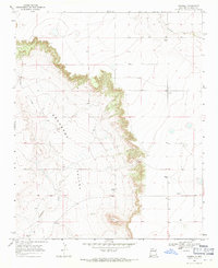
 1968 Quemado Hills1971 Print · USGSIn the high country of Quay County during the late sixties, the iron rails dominated the northern horizon. Trace the path of the Chicago Rock Island and Pacific railroad as it skirts Mesa Del Puerta and the prominent Quemado Hills.
 - 1968 Map of Bascom Camp, 1971 Print
 1968 Bascom Camp1971 Print · USGSThe ranching country of eastern New Mexico is captured in the late sixties, just as the Ute Reservoir began reshaping the landscape. Researchers can trace the massive Pablo Montoya grant and find specific cattle sites like Bascom Camp and Bascom Pens.
 - 1968 Map of Rock Camp, 1971 Print
 1968 Rock Camp1971 Print · USGSThe New Mexico and Texas borderlands in the late sixties reveal a ranching landscape defined by remote outposts and vital water sources. Researchers can trace historic property boundaries and grazing infrastructure through named sites like Purcell Ranch, Rock Camp, and Chandler Windmills.3 unique versions available
 - 1968 Map of Hampton Ranch, 1971 Print
 1968 Hampton Ranch1971 Print · USGSThe high plains ranchlands of San Miguel County come into focus during the late 1960s, a landscape defined by expansive land grants and seasonal water. Researchers can trace historical ranching outposts and family landmarks like Hampton Ranch, McCuistion Camp, and the remote Bryantine Cem.
 - 1968 Map of Blue Hole, 1971 Print
 1968 Blue Hole1971 Print · USGSQuay County ranching country is captured here in the late sixties, showing a landscape defined by the search for water. Researchers can trace family-named landmarks and remote outposts like Collins Ranch, the small Cem, and Shaffer Windmill.
 - 1968 Map of Candy Mesa, 1971 Print
 1968 Candy Mesa1971 Print · USGSThe ranching country along the De Baca and Quay county line is captured here in the late sixties, where the high desert meets the mesas. Researchers can locate family-held lands like Knighten Ranch and trace the topography from Gerhardt Valley to Charlotte Point.2 unique versions available
 - 1968 Map of Bulldog Mesa, 1971 Print
 1968 Bulldog Mesa1971 Print · USGSQuay County ranching and water management are the focus of this late 1960s survey of the high plains. Researchers can locate remote family homesteads like Stallard Ranch and Dennis Ranch or trace rural burial sites at Newhome Cem.
 - 1968 Map of Riley Camp, 1971 Print
 1968 Riley Camp1971 Print · USGSThe Quay County high plains during the late sixties are captured here, showing the intersection of cattle ranching and the Rock Island railroad. Researchers can locate family landmarks like Davidson Ranch and trace regional history through Bard Cem and Boot Hill Cem.2 unique versions available
 - 1968 Map of Ima NW, 1971 Print
 1968 Ima NW1971 Print · USGSGuadalupe and Quay Counties are shown in the late 1960s as a landscape of remote cattle ranches and high mesas. Local researchers can locate family-named landmarks like Hornsby Ranch and Pettigrew Ranch or the isolated Ruth Cem.
Showing maps 1-25 of 43
Top cities of Quay County
Frequently asked questions
- What are the different types of historical maps available for Quay County?
- What is the oldest map of Quay County?
- Where can I purchase historical maps of Quay County for my home or office?
- Where can I download high-res historical maps of Quay County?
- Are there historical topographic maps available for Quay County?
- Is there historical aerial imagery available for Quay County?
- Where are historical maps of Quay County sourced from?