1980s Maps of Quay County, New Mexico
Explore 6 historic maps of Quay County from the 1980s. These maps offer a rare glimpse into what life looked like during the 1980s — showing old roads, neighborhoods, homes, and landmarks that have changed or disappeared over time.
Whether you're researching your family's past, planning a metal detecting trip, or studying how Quay County's landscape evolved across the 1980s, these high-resolution maps are a powerful tool for exploring the history of this region.
- Focus on a specific era: All maps on this page are from the 1980s, giving you a focused view of this time period.
- See what’s changed: Compare century-old streets, trails, and buildings to today's modern landscape using overlays and satellite layers.
- Research with precision: Use these maps for genealogy, historical research, land use analysis, or educational projects.
- View, download, or print: Maps are fully viewable online in high resolution, and can be downloaded or printed for your own records.
Start exploring Quay County's history through authentic maps from the 1980s. This is your window into the past.
Quay County, NM maps
(6)- 1984 Map of Santa Rosa, 1992 Print
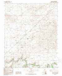
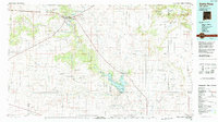 1984 Santa Rosa1992 Print · USGSEast-central New Mexico is captured here in the mid-1980s, centered on the strategic river crossing at Santa Rosa. Researchers can trace family-named landforms and small outposts like Puerto de Luna, Pastura, and the varied arroyos feeding into Lake Sumner.
 - 1985 Map of Hammond Ranch
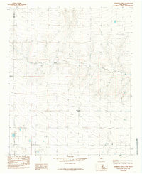 1985 Hammond Ranch1985 Print · USGSThe ranching country of eastern New Mexico is captured here in the mid-1980s, centered on the high plains near the Quay and Curry County line. Genealogists and local historians can locate Hammond Ranch and trace the path of Frio Draw through this cattle-raising region.
 - 1989 Map of Tuscocoillo Canyon
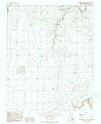 1989 Tuscocoillo Canyon1989 Print · USGSQuay County ranching land is documented here in the late eighties, showing a landscape defined by canyons and water rights. Researchers can trace family-named landmarks like Molyneaux Ranch and isolated rural infrastructure such as Ealen Windmill or Wallin Well.
 - 1989 Map of Logan South
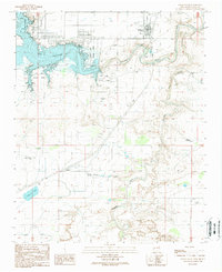 1989 Logan South1989 Print · USGSLogan and the surrounding Quay County ranchlands are captured here in the late eighties as recreational life at the reservoir expanded. Researchers can find specific local landmarks like the Ute Dam Airport, the Rodeo Ground, and small settlements including Mater and Martinez.
 - 1989 Map of Logan NE
 1989 Logan NE1989 Print · USGSIn the late twentieth century, this portion of Quay County remained a dedicated ranching landscape centered on the Canadian River. Researchers can trace old family ranching legacies through named features like Shoenail Ranch, Sand Springs, and the Blue Hole.
 - 1989 Map of Logan North
 1989 Logan North1989 Print · USGSThe high plains of the New Mexico borderlands come into focus in the late eighties, centered on the growth of Logan near the water's edge. Genealogists and historians can trace family ranch sites like House Ranch Well and McFarland Well or locate the Logan Cem.
End of results
Showing maps 1-6 of 6
Top cities of Quay County
Frequently asked questions
- What are the different types of historical maps available for Quay County?
- What is the oldest map of Quay County?
- Where can I purchase historical maps of Quay County for my home or office?
- Where can I download high-res historical maps of Quay County?
- Are there historical topographic maps available for Quay County?
- Is there historical aerial imagery available for Quay County?
- Where are historical maps of Quay County sourced from?