1950s Maps of Taos County, New Mexico
Explore 9 historic maps of Taos County from the 1950s. These maps offer a rare glimpse into what life looked like during the 1950s — showing old roads, neighborhoods, homes, and landmarks that have changed or disappeared over time.
Whether you're researching your family's past, planning a metal detecting trip, or studying how Taos County's landscape evolved across the 1950s, these high-resolution maps are a powerful tool for exploring the history of this region.
- Focus on a specific era: All maps on this page are from the 1950s, giving you a focused view of this time period.
- See what’s changed: Compare century-old streets, trails, and buildings to today's modern landscape using overlays and satellite layers.
- Research with precision: Use these maps for genealogy, historical research, land use analysis, or educational projects.
- View, download, or print: Maps are fully viewable online in high resolution, and can be downloaded or printed for your own records.
Start exploring Taos County's history through authentic maps from the 1950s. This is your window into the past.
Taos County, NM maps
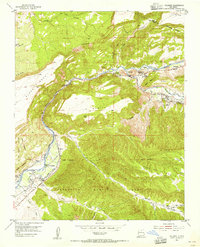
(9)- 1953 Map of Truchas, 1955 Print
 1953 Truchas1955 Print · USGSNorthern New Mexico's high-altitude villages and traditional land grants are meticulously documented during the mid-century. Researchers can trace historic acequias and property lines within the Las Trampas Grant or locate ancestral sites in Truchas, Cordova, and Ojo Sarco.4 unique versions available
 - 1953 Map of Velarde, 1955 Print
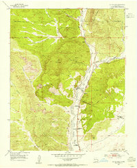
 1953 Velarde1955 Print · USGSThe Rio Grande valley in the early fifties shows a landscape of traditional irrigation and canyon settlements. Genealogists and historians can trace the Low Ditch system through Velarde, find the Embudo Presbyterian Hospital, and locate family plots in the Dixon Cemeteries.2 unique versions available
 - 1953 Map of Trampas, 1955 Print
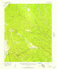
 1953 Trampas1955 Print · USGSNorthern New Mexico in the early fifties shows a landscape defined by deep canyons and ancient land grants. Researchers can trace the village layout of Trampas near the Iglesia de Santo Tomas and locate old mining operations like the Harding Mine.3 unique versions available
 - 1953 Map of Ojo Caliente, 1955 Print
 1953 Ojo Caliente1955 Print · USGSThe high desert of Taos and Rio Arriba Counties comes into focus during the early fifties, centering on the historic Ojo Caliente grant. Genealogists and historians can trace the foundations of local life at the Ojo Caliente Cemetery, the San Texas Mine, and the post office at Gallegos.3 unique versions available
 - 1954 Map of Raton, 1963 Print
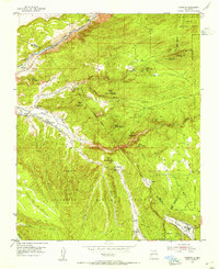
 1954 Raton1963 Print · USGSNorthern New Mexico's high-country and plains are documented here in the early sixties, showing the region's ranching and mining infrastructure. Trace the legacy of the Maxwell Land Grant, locate remote rural sites like Tafoya School, and follow the Atchison Topeka and Santa Fe Railway through the heart of Raton.3 unique versions available
 - 1954 Map of Aztec, 1975 Print
 1954 Aztec1975 Print · USGSNorthern New Mexico and southern Colorado come alive in the mid-1950s, showing the high-country settlements and tribal lands of the San Juan Basin. Genealogists and historians can trace the path of the Denver & Rio Grande Western RR and locate communities like Abiquiu, Park View, and Lumberton.4 unique versions available
 - 1955 Map of Ute Park, 1957 Print
 1955 Ute Park1957 Print · USGSColfax County in the mid-1950s shows a landscape of storied land grants and high-country mining. You can trace the legacy of the Maxwell Grant and locate old workings at the Aztec Mine or the historic Virginia City site.5 unique versions available
 - 1958 Map of Raton
 1958 Raton1958 Print · USGSNorthern New Mexico and the Colorado borderlands are mapped here in the late fifties, showcasing a landscape of high peaks and historic land grants. Genealogists and historians can trace families across Picuris Pueblo, find old schoolhouses like Piedra Lumbre School, or follow the Atchison Topeka and Santa Fe rail line.3 unique versions available
 - 1958 Map of Aztec
 1958 Aztec1958 Print · USGSNorthern New Mexico and the southern Colorado border are captured here during the mid-fifties, showing the rugged intersection of national forests and tribal lands. Researchers can trace the Denver and Rio Grande Western rail line and locate remote outposts like Blanco Trading Post or Sargent Ranch.
End of results
Showing maps 1-9 of 9
Top cities of Taos County
- Taos historical maps
- Questa historical maps
- Red River historical maps
- Costilla historical maps
- Taos Ski Valley historical maps
Frequently asked questions
- What are the different types of historical maps available for Taos County?
- What is the oldest map of Taos County?
- Where can I purchase historical maps of Taos County for my home or office?
- Where can I download high-res historical maps of Taos County?
- Are there historical topographic maps available for Taos County?
- Is there historical aerial imagery available for Taos County?
- Where are historical maps of Taos County sourced from?