1980s Maps of Taos County, New Mexico
Explore 6 historic maps of Taos County from the 1980s. These maps offer a rare glimpse into what life looked like during the 1980s — showing old roads, neighborhoods, homes, and landmarks that have changed or disappeared over time.
Whether you're researching your family's past, planning a metal detecting trip, or studying how Taos County's landscape evolved across the 1980s, these high-resolution maps are a powerful tool for exploring the history of this region.
- Focus on a specific era: All maps on this page are from the 1980s, giving you a focused view of this time period.
- See what’s changed: Compare century-old streets, trails, and buildings to today's modern landscape using overlays and satellite layers.
- Research with precision: Use these maps for genealogy, historical research, land use analysis, or educational projects.
- View, download, or print: Maps are fully viewable online in high resolution, and can be downloaded or printed for your own records.
Start exploring Taos County's history through authentic maps from the 1980s. This is your window into the past.
Taos County, NM maps
(6)- 1981 Map of Chama, 1982 Print
 1981 Chama1982 Print · USGSNorthern New Mexico's high-country rail corridors and historic land grants are mapped here as they appeared in the early eighties. Genealogists and historians can trace traditional settlements like Los Ojos and Tierra Amarilla or follow the narrow-gauge Cumbres and Toltec Scenic Railroad.
 - 1982 Map of Wheeler Peak, 1983 Print
 1982 Wheeler Peak1983 Print · USGSNorthern New Mexico in the early eighties shows a high-altitude landscape of historic mining camps and massive land grants. Researchers can trace the Old Railroad Grade near Elizabethtown or locate remote sites like the French-Henry Mine and Vermejo Park.
 - 1983 Map of Taos
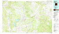
 1983 Taos1983 Print · USGSNorthern New Mexico's high-country heritage is on full display in the early eighties, from the deep river canyons to the highest alpine peaks. Genealogists and historians can trace traditional land-grant settlements like Las Trampas, Truchas, and the historic Taos Pueblo.2 unique versions available
 - 1986 Map of Ash Mountain
 1986 Ash Mountain1986 Print · USGSNorthern New Mexico's high-country wilderness is captured here in the mid-1980s, detailing the intersection of Taos and Colfax counties. Hikers and historians can trace the paths near Little Costilla Peak, the drainage of Shuree Creek, and the massive The Rock Wall formation.
 - 1986 Map of The Wall
 1986 The Wall1986 Print · USGSThe Sangre de Cristo high country on the Colorado-New Mexico border is captured here in the mid-1980s, documenting the remote land grants and watersheds of Colfax County. Researchers can trace historic mining and land use through the Van Lint Mine, a lone Cemetery, and high-altitude water sources like Underwood Lakes and Bernal Lake.
 - 1987 Map of Baldy Mountain
 1987 Baldy Mountain1987 Print · USGSThe high peaks and mining history of Colfax County are preserved here in the late eighties. Researchers can locate remote outposts like French Henry Camp, the historic Aztec Mine, and the sprawling boundaries of the Philmont Scout Ranch.2 unique versions available
End of results
Showing maps 1-6 of 6
Top cities of Taos County
- Taos historical maps
- Questa historical maps
- Red River historical maps
- Costilla historical maps
- Taos Ski Valley historical maps
Frequently asked questions
- What are the different types of historical maps available for Taos County?
- What is the oldest map of Taos County?
- Where can I purchase historical maps of Taos County for my home or office?
- Where can I download high-res historical maps of Taos County?
- Are there historical topographic maps available for Taos County?
- Is there historical aerial imagery available for Taos County?
- Where are historical maps of Taos County sourced from?