1970s Maps of Sampson County, North Carolina
Explore 7 historic maps of Sampson County from the 1970s. These maps offer a rare glimpse into what life looked like during the 1970s — showing old roads, neighborhoods, homes, and landmarks that have changed or disappeared over time.
Whether you're researching your family's past, planning a metal detecting trip, or studying how Sampson County's landscape evolved across the 1970s, these high-resolution maps are a powerful tool for exploring the history of this region.
- Focus on a specific era: All maps on this page are from the 1970s, giving you a focused view of this time period.
- See what’s changed: Compare century-old streets, trails, and buildings to today's modern landscape using overlays and satellite layers.
- Research with precision: Use these maps for genealogy, historical research, land use analysis, or educational projects.
- View, download, or print: Maps are fully viewable online in high resolution, and can be downloaded or printed for your own records.
Start exploring Sampson County's history through authentic maps from the 1970s. This is your window into the past.
Sampson County, NC maps
(7)- 1973 Map of Dunn, 1975 Print
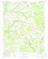
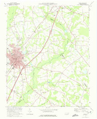 1973 Dunn1975 Print · USGSDunn and Benson were thriving railroad and agricultural hubs in the early 1970s. Genealogists and local historians can trace family church roots at Jonesboro Ch and Mingo Hill Ch or locate landmarks like the Young Lookout Tower.2 unique versions available
 - 1974 Map of Salemburg, 1977 Print
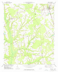
 1974 Salemburg1977 Print · USGSSampson County in the mid-1970s reveals a landscape of rural crossroads and intricate swamp networks. Researchers can trace the communities of Salemburg and Rebel City, locating landmarks like Clement Sch, Crumpler Millpond, and numerous family burial sites.
 - 1974 Map of Wade, 1977 Print
 1974 Wade1977 Print · USGSCumberland County communities like Wade and Godwin are shown in the mid-1970s as they balanced rural tradition with expanding transit corridors. Genealogists and local historians can trace family locations through numerous rural landmarks, including Westminster Cem, Spring Hill Ch, and the Averasboro Battleground Monument.2 unique versions available
 - 1974 Map of Stedman, 1977 Print
 1974 Stedman1977 Print · USGSCumberland County’s coastal plain landscape is captured here in the mid-1970s, as rural communities thrived along the South River and the rail line. Researchers can trace family roots through numerous sites like Bethany Crossroads, Fisher Cem, and Magnolia Ch.2 unique versions available
 - 1974 Map of Mingo, 1977 Print
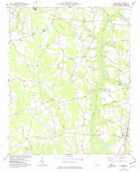
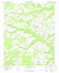
 1974 Mingo1977 Print · USGSSampson County's rural landscape is mapped here in the mid-seventies, showing a community defined by its sprawling swamp basins and country churches. Genealogists can trace family landmarks like Naylor Cem, Jackson Cem, and the Tart Millpond near the settlement of Mingo.
 - 1975 Map of Faison, 1977 Print
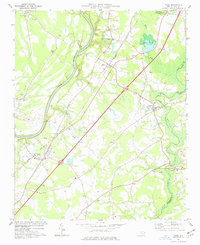
 1975 Faison1977 Print · USGSThe coastal plain of North Carolina is captured here in the mid-seventies, showing the intersection of the Seaboard Coast Line and rural farming life. Genealogists can locate family landmarks like Millers Chapel, Hargrove Sch, and dozens of unnamed rural cemeteries near Faison.
 - 1978 Map of Dobbersville
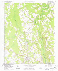
 1978 Dobbersville1978 Print · USGSSampson County and the surrounding tri-county area are shown in the late 1970s, characterized by rural settlements and expansive swamp systems. Genealogists can trace family connections through numerous country churches like Brownings Ch and Goshen Ch or locate homes near Suttontown.
End of results
Showing maps 1-7 of 7
Top cities of Sampson County
- Clinton historical maps
- Roseboro historical maps
- Newton Grove historical maps
- Keener historical maps
- Salemburg historical maps
- Delway historical maps
See more
Frequently asked questions
- What are the different types of historical maps available for Sampson County?
- What is the oldest map of Sampson County?
- Where can I purchase historical maps of Sampson County for my home or office?
- Where can I download high-res historical maps of Sampson County?
- Are there historical topographic maps available for Sampson County?
- Is there historical aerial imagery available for Sampson County?
- Where are historical maps of Sampson County sourced from?