1990s Maps of Sampson County, North Carolina
Explore 9 historic maps of Sampson County from the 1990s. These maps offer a rare glimpse into what life looked like during the 1990s — showing old roads, neighborhoods, homes, and landmarks that have changed or disappeared over time.
Whether you're researching your family's past, planning a metal detecting trip, or studying how Sampson County's landscape evolved across the 1990s, these high-resolution maps are a powerful tool for exploring the history of this region.
- Focus on a specific era: All maps on this page are from the 1990s, giving you a focused view of this time period.
- See what’s changed: Compare century-old streets, trails, and buildings to today's modern landscape using overlays and satellite layers.
- Research with precision: Use these maps for genealogy, historical research, land use analysis, or educational projects.
- View, download, or print: Maps are fully viewable online in high resolution, and can be downloaded or printed for your own records.
Start exploring Sampson County's history through authentic maps from the 1990s. This is your window into the past.
Sampson County, NC maps
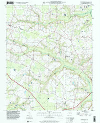
(9)- 1997 Map of Newton Grove North, 2000 Print
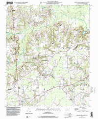 1997 Newton Grove North2000 Print · USGSThe rural borderlands of Johnston, Sampson, and Wayne counties are captured here in the late nineties, centered on the significant Bentonville Battleground. Researchers can trace the layout of Newton Grove or locate family-named landmarks and rural congregations like Ebenezer Ch and St John Ch.
 - 1997 Map of Faison, 2000 Print
 1997 Faison2000 Print · USGSIn the late 1990s, the rural borderlands of Sampson and Duplin Counties remained a landscape of deep swamps and scattered country parishes. Researchers can trace historic family locations and local institutions such as Hargrove Sch, Bethlehem Ch, and Poplar Grove.
 - 1997 Map of Dunn, 2000 Print
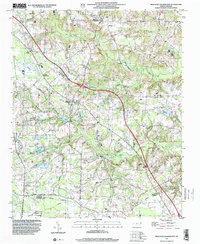
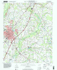 1997 Dunn2000 Print · USGSThe area surrounding Dunn and Benson is captured in the late nineties, documenting a landscape of rural crossroads and established schools. Researchers can trace family sites at Mary Stewart Sch, Savannah Hill Ch, or the Mingo Primitive Ch.
 - 1997 Map of Stedman, 2000 Print
 1997 Stedman2000 Print · USGSCoastal plain settlements east of Fayetteville thrived amidst the wetlands and creeks of the North Carolina interior in the late nineties. Researchers can trace family history through numerous landmarks like China Grove Ch, Fisher Cem, and the rural crossroads of Stedman.
 - 1997 Map of Dobbersville, 2000 Print
 1997 Dobbersville2000 Print · USGSThe rural borders of Sampson and Wayne counties come into focus during the late 1990s, showcasing a landscape of isolated farmsteads and swampy lowlands. Researchers can locate numerous small burial sites and historic congregations like Smith Chapel or Wesley Ch near Dobbersville.
 - 1997 Map of Timothy, 2000 Print
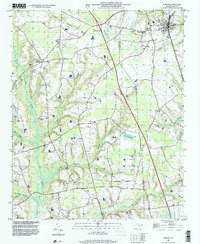
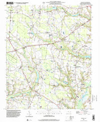 1997 Timothy2000 Print · USGSSampson County's rural character and family-held lands are preserved in this late-nineties survey of the North Carolina coastal plain. Researchers can locate numerous small-town landmarks and cemeteries near Spiveys Corner, Midway, and Blackmans Grove Ch.
 - 1997 Map of Newton Grove South, 2000 Print
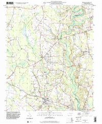
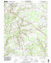 1997 Newton Grove South2000 Print · USGSSampson County settlement patterns are well-defined in the late nineties, centered on the crossroads at Newton Grove. Genealogists can trace family connections through numerous rural landmarks like St Matthew Ch, Hobton, and Marys Chapel.
 - 1997 Map of Peacocks Crossroads, 2000 Print
 1997 Peacocks Crossroads2000 Print · USGSCoastal plain crossroads and agricultural lands in the late nineties show a community woven through wetlands and family farms. Researchers can trace rural genealogy and landmarks through Peacocks Crossroads, the Meadow School, and Massengill Airport.
 - 1997 Map of Wallace West, 2001 Print
 1997 Wallace West2001 Print · USGSCoastal plain life in the late nineties is defined by the rural settlements and creek systems of Pender and Duplin counties. Genealogists and historians can trace family roots through sites like Alderman Cem, the planned community layout of Penderlea, and an Old Railroad Grade.
End of results
Showing maps 1-9 of 9
Top cities of Sampson County
- Clinton historical maps
- Roseboro historical maps
- Newton Grove historical maps
- Keener historical maps
- Salemburg historical maps
- Delway historical maps
See more
Frequently asked questions
- What are the different types of historical maps available for Sampson County?
- What is the oldest map of Sampson County?
- Where can I purchase historical maps of Sampson County for my home or office?
- Where can I download high-res historical maps of Sampson County?
- Are there historical topographic maps available for Sampson County?
- Is there historical aerial imagery available for Sampson County?
- Where are historical maps of Sampson County sourced from?