1980s Maps of Sampson County, North Carolina
Explore 23 historic maps of Sampson County from the 1980s. These maps offer a rare glimpse into what life looked like during the 1980s — showing old roads, neighborhoods, homes, and landmarks that have changed or disappeared over time.
Whether you're researching your family's past, planning a metal detecting trip, or studying how Sampson County's landscape evolved across the 1980s, these high-resolution maps are a powerful tool for exploring the history of this region.
- Focus on a specific era: All maps on this page are from the 1980s, giving you a focused view of this time period.
- See what’s changed: Compare century-old streets, trails, and buildings to today's modern landscape using overlays and satellite layers.
- Research with precision: Use these maps for genealogy, historical research, land use analysis, or educational projects.
- View, download, or print: Maps are fully viewable online in high resolution, and can be downloaded or printed for your own records.
Start exploring Sampson County's history through authentic maps from the 1980s. This is your window into the past.
Sampson County, NC maps
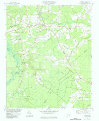
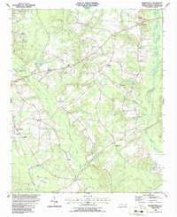
(23)- 1982 Map of Elizabethtown, 1983 Print
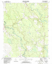
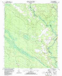
 1982 Elizabethtown1983 Print · USGSSoutheastern North Carolina's coastal plain is captured here in the early eighties, showcasing a landscape defined by the Cape Fear River and mysterious Carolina Bays. Genealogists and researchers can trace the rail network of the Seaboard Coast Line through rural communities like Autryville, Ivanhoe, and the recreational hub of White Lake.
 - 1984 Map of Harrells
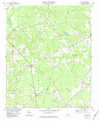
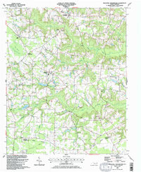
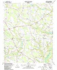
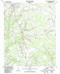
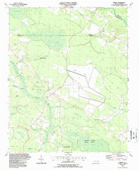
 1984 Harrells1984 Print · USGSSampson County settlement patterns in the early eighties are anchored by the rural community of Harrells. Genealogists and historians can trace family roots through numerous sites like Iron Mine Burial Park, Bland Sch, and the Melvin Cem.
 - 1984 Map of Delway
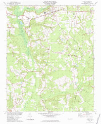
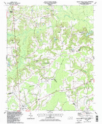
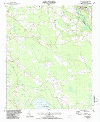
 1984 Delway1984 Print · USGSCoastal Plain landscapes along the Sampson and Duplin county line are shown in the early eighties, revealing a world of isolated crossroads and bay pocosins. Trace family roots at Evergreen Cem and Merritt Mem Cem, or locate landmarks like Taylors Bridge and the unique Pig In Bay.
 - 1984 Map of Turkey
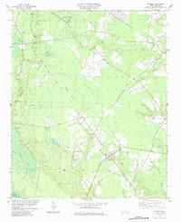
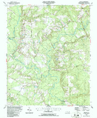
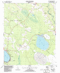
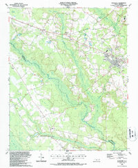
 1984 Turkey1984 Print · USGSCoastal plain settlements in Sampson County are mapped here in the early eighties, showing a landscape shaped by the SEABOARD rail line and numerous creek branches. Researchers can trace rural church history and family sites at St Stephens Ch, Piney Grove Ch, and Moltonville.
 - 1984 Map of Atkinson
 1984 Atkinson1984 Print · USGSThe town of Atkinson and the Black River bottomlands are captured here in the early 1980s, revealing a landscape of family-run farms and vast bay-swamp geography. Researchers can trace local history through sites like New Zion Ch, Atkinson Cem, and the old Railroad Grade.
 - 1984 Map of Wallace West
 1984 Wallace West1984 Print · USGSIn the 1980s, the Pender County countryside reflected a mix of New Deal planning and deep-rooted family history. Trace the layout of Penderlea or locate family sites like Alderman Cem and Newkirk Chapel along the Rockfish Creek basin.
 - 1986 Map of Peacocks Crossroads
 1986 Peacocks Crossroads1986 Print · USGSCoastal plain farming and wetland communities thrive in Johnston County during the mid-1980s. Genealogists and local historians can trace family landmarks and rural congregations, including Barefoot Cem, Holly Grove Ch, and Peacocks Crossroads.2 unique versions available
 - 1986 Map of Ingold
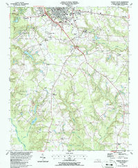
 1986 Ingold1986 Print · USGSSampson County's rural landscape is captured here in the mid-1980s, centered on the river-fed communities of Ingold and Clear Run. Genealogists and researchers can trace numerous unnamed cemeteries and local institutions like Union High School and Salem Church.
 - 1986 Map of Garland
 1986 Garland1986 Print · USGSSampson and Bladen counties in the mid-1980s are defined by the convergence of the South River and several distinctive Carolina Bays. Researchers can trace rural community centers through old landmarks like Smith Chapel, Antioch Ch, and Parkersburg.
 - 1986 Map of Clinton South
 1986 Clinton South1986 Print · USGSCoastal plain agriculture and transit dominate this mid-eighties record of southern Sampson County. Researchers can trace the roots of rural communities at Butlers Crossroads and Moltonville or locate family sites at St Paul Ch and Union Chapel.
 - 1986 Map of Bonnetsville
 1986 Bonnetsville1986 Print · USGSSampson County's coastal plain in the mid-1980s is captured here, showing a landscape shaped by rural industry and deep-rooted communities. Researchers can trace family history through numerous landmarks like Elizabeth Ch, Robinson Chapel, and the community of Bonnetsville.
 - 1986 Map of Timothy
 1986 Timothy1986 Print · USGSSampson County's rural landscape is captured here in the mid-1980s, showcasing a network of family-named crossroads and country churches. Genealogists can trace local roots at Roanoke Chapel, Vann Crossroads, and the grounds of Midway High Sch.
 - 1986 Map of Clinton North
 1986 Clinton North1986 Print · USGSSampson County during the mid-1980s shows a landscape of growing regional hubs and established rural crossroads. Genealogists and local historians can trace family sites at Sandhills Cem, old school locations like Halls-Piney Grove Sch, and community landmarks from Browns Chapel to the Drive-in Theater.
 - 1986 Map of Bearskin
 1986 Bearskin1986 Print · USGSSampson County in the mid-1980s is a landscape of rural crossroads and historic church communities. Researchers can trace family roots through local landmarks like Beaman Crossroads, Sampson Chapel, and the settlement of Kitty Fork.
 - 1986 Map of Tomahawk
 1986 Tomahawk1986 Print · USGSCoastal plain river life and unique swamp geography define this Sampson County region in the mid-1980s. Researchers can trace rural lineages through sites like Trinity Ch and Harmony Ch or locate old river access points at Fowler Landing and Jackie Landing.
 - 1986 Map of Newton Grove South
 1986 Newton Grove South1986 Print · USGSSampson County in the mid-1980s reveals a rural landscape shaped by ancient watercourses and deep-rooted church communities. Genealogists can trace family footprints through numerous crossroads and landmarks like Monks Crossroads, Hobbton, and Marys Chapel.
 - 1986 Map of Newton Grove North
 1986 Newton Grove North1986 Print · USGSCoastal Plain farmland meets civil war history in this mid-1980s survey of the Johnston and Sampson county border. Genealogists can trace family landmarks and rural congregations like Strickland Crossroads, Bentonville, and Antioch Ch.
 - 1986 Map of Fayetteville
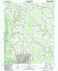
 1986 Fayetteville1986 Print · USGSThe North Carolina coastal plain appears in the mid-1980s as a bustling corridor of military installations and historic tobacco towns. Genealogists and historians can trace the footprints of Fort Bragg Military Reservation, Campbell University, and the rail lines of the Seaboard Coast Line RR.2 unique versions available
 - 1986 Map of White Lake
 1986 White Lake1986 Print · USGSCoastal Bladen County in the mid-1980s is a landscape of distinct Carolina Bays and state-protected timberlands. Local historians can trace the development around White Lake or locate family sites like Marshburn Cems and Hickory Grove Crossroads.
 - 1986 Map of Rowan
 1986 Rowan1986 Print · USGSThe Black River basin on the Bladen-Sampson county line is captured here in the mid-1980s, showing a landscape defined by expansive bays and river landings. Genealogists and local historians can locate Moore Swamp Ch, Salem Cem, and several historic river access points like Tar Landing.
 - 1987 Map of Ammon
 1987 Ammon1987 Print · USGSCoastal plains and pocosin wetlands define this portion of Bladen County in the late eighties. Researchers can trace rural lineages through numerous local sites like Ammon, Windsor Ch, and the many family-named depressions like Cain Bay.
 - 1987 Map of Autryville
 1987 Autryville1987 Print · USGSSettled along the South River in the late eighties, the area around Autryville maintains its rural rail-and-timber character. Researchers can trace historic church sites like St Johns Ch and Union Hill Ch or explore the unique geography of Bushy Lake.
 - 1987 Map of Roseboro
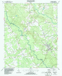
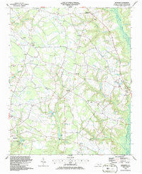
 1987 Roseboro1987 Print · USGSRoseboro and the surrounding Sampson County swamplands are captured here in the late twentieth century, showing a landscape defined by the South River. Researchers can locate numerous rural landmarks like Beaver Dam Sch, Mill Creek Ch, and an Old Railroad Grade.
End of results
Showing maps 1-23 of 23
Top cities of Sampson County
- Clinton historical maps
- Roseboro historical maps
- Newton Grove historical maps
- Keener historical maps
- Salemburg historical maps
- Delway historical maps
See more
Frequently asked questions
- What are the different types of historical maps available for Sampson County?
- What is the oldest map of Sampson County?
- Where can I purchase historical maps of Sampson County for my home or office?
- Where can I download high-res historical maps of Sampson County?
- Are there historical topographic maps available for Sampson County?
- Is there historical aerial imagery available for Sampson County?
- Where are historical maps of Sampson County sourced from?