1980s Maps of Bowman County, North Dakota
Explore 11 historic maps of Bowman County from the 1980s. These maps offer a rare glimpse into what life looked like during the 1980s — showing old roads, neighborhoods, homes, and landmarks that have changed or disappeared over time.
Whether you're researching your family's past, planning a metal detecting trip, or studying how Bowman County's landscape evolved across the 1980s, these high-resolution maps are a powerful tool for exploring the history of this region.
- Focus on a specific era: All maps on this page are from the 1980s, giving you a focused view of this time period.
- See what’s changed: Compare century-old streets, trails, and buildings to today's modern landscape using overlays and satellite layers.
- Research with precision: Use these maps for genealogy, historical research, land use analysis, or educational projects.
- View, download, or print: Maps are fully viewable online in high resolution, and can be downloaded or printed for your own records.
Start exploring Bowman County's history through authentic maps from the 1980s. This is your window into the past.
Bowman County, ND maps
(11)- 1980 Map of Marmarth
 1980 Marmarth1980 Print · USGSThe Little Missouri River valley in the late twentieth century reveals a landscape defined by the Chicago Milwaukee St Paul and Pacific railroad and ranching life. Genealogists and historians can trace the townsite of Marmarth, find the Riverside Cemetery, and locate the Rodeo Ground and Pretty Butte.
 - 1980 Map of Camp Crook
 1980 Camp Crook1980 Print · USGSNorthwestern South Dakota and the North Dakota borderlands come into focus in the late seventies, showing a landscape of high buttes and river breaks. Researchers can trace remote ranching outposts like Ralph and Ladner or locate landmarks like Window Rock and the Harding County Airport.
 - 1980 Map of Mott, 1981 Print
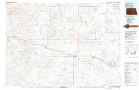
 1980 Mott1981 Print · USGSThe North Dakota plains around the turn of the 1980s reveal a landscape of river-valley farming and critical rail connections. Researchers can trace the path of the Milwaukee Road through Bucyrus or locate landmarks like East Rainy Butte and Tepee Buttes.
 - 1980 Map of Snider Hill, 1983 Print
 1980 Snider Hill1983 Print · USGSThe tri-state corner of Montana and the Dakotas is captured in the early 1980s, showcasing the high-plains ranching landscape. Trace the winding waters of Boxelder Creek and Coal Bank Creek as they cut between landmarks like Snider Hill and Monument Butte.
 - 1981 Map of Baker
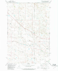
 1981 Baker1981 Print · USGSThe Montana-North Dakota borderlands are captured here in the early 1980s, showcasing the high plains ranching and rail corridor. Genealogists can locate rural landmarks like Lame Jones School and the Milwaukee Road railroad route through Plevna and Ismay.
 - 1981 Map of Scole School
 1981 Scole School1981 Print · USGSThe Montana and North Dakota border comes alive in the early eighties as a hub of energy production. Genealogists and local historians can trace the footprint of the Little Beaver East Oil Field and find landmarks like Scole Sch and the remote Landing Strip.
 - 1981 Map of Bowman
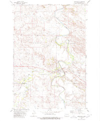
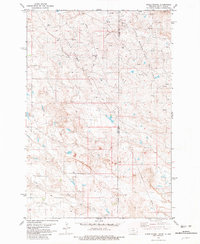
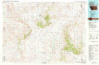
 1981 Bowman1981 Print · USGSSouthwestern North Dakota in the early eighties was a landscape of high-plains ranching and rail-centered commerce. Genealogists and historians can trace the rail towns of Bowman, Marmarth, and Amidon while identifying landmarks like White Butte and Talbot Butte.
 - 1981 Map of Webster NE
 1981 Webster NE1981 Print · USGSThe high plains along the North Dakota and Montana border are captured here in the early 1980s as the local energy economy expanded. Genealogists and historians can trace the network of Gas Wells and Oil Wells throughout the Little Beaver East Oil Field and the banks of Little Beaver Creek.
 - 1981 Map of Waterhole Creek
 1981 Waterhole Creek1981 Print · USGSThe Montana-North Dakota borderlands are captured here in the early eighties, showing a landscape defined by prairie watercourses and remote rail lines. Genealogists and local historians can locate the Fertile Prairie Cem, Fertile Prairie Sch, and the route of the Chicago Milwaukee St Paul and Pacific railroad.
 - 1982 Map of Ekalaka, 1983 Print
 1982 Ekalaka1983 Print · USGSEastern Montana ranching country and the tri-state border lands are meticulously documented in the early 1980s. Local historians can trace the remote settlement of Ekalaka, the landmarks of Medicine Rocks, and the rugged profiles of Chalk Buttes and Long Pine Hills.
 - 1984 Map of Lemmon
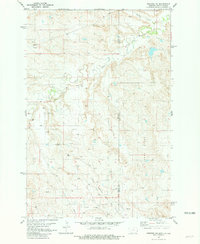
 1984 Lemmon1984 Print · USGSThe High Plains borderlands of South Dakota and North Dakota are documented here in the mid-1980s, centered on the Lemmon and Hettinger rail corridor. Genealogists and historians can trace local landmarks like Strool, the Shadehill Reservoir shoreline, and isolated buttes including White Butte and Square Top Butte.2 unique versions available
End of results
Showing maps 1-11 of 11
Top cities of Bowman County
- Bowman historical maps
- Scranton historical maps
- Rhame historical maps
- Haley historical maps
- Gascoyne historical maps
Frequently asked questions
- What are the different types of historical maps available for Bowman County?
- What is the oldest map of Bowman County?
- Where can I purchase historical maps of Bowman County for my home or office?
- Where can I download high-res historical maps of Bowman County?
- Are there historical topographic maps available for Bowman County?
- Is there historical aerial imagery available for Bowman County?
- Where are historical maps of Bowman County sourced from?