1800s (19th Century) Maps of Kingfisher County, Oklahoma
Explore 7 historic maps of Kingfisher County from the 1800s (19th Century). These maps offer a rare glimpse into what life looked like during the 1800s — showing old roads, neighborhoods, homes, and landmarks that have changed or disappeared over time.
Whether you're researching your family's past, planning a metal detecting trip, or studying how Kingfisher County's landscape evolved across the 1800s, these high-resolution maps are a powerful tool for exploring the history of this region.
- Focus on a specific era: All maps on this page are from the 1800s, giving you a focused view of this time period.
- See what’s changed: Compare century-old streets, trails, and buildings to today's modern landscape using overlays and satellite layers.
- Research with precision: Use these maps for genealogy, historical research, land use analysis, or educational projects.
- View, download, or print: Maps are fully viewable online in high resolution, and can be downloaded or printed for your own records.
Start exploring Kingfisher County's history through authentic maps from the 1800s. This is your window into the past.
Kingfisher County, OK maps
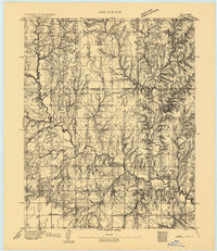
(7)- 1892 Map of Kingfisher, 1957 Print
 1892 Kingfisher1957 Print · USGSOklahoma Territory was in a state of rapid transition during the 1890s as railroads and cattle trails shared the same landscape. Researchers can trace the original Chisholm Trail alongside early settlements like Mathewson and river crossings such as Kirby Ford.
 - 1893 Map of Fort Reno
 1893 Fort Reno1893 Print · USGSCentral Oklahoma's frontier landscape is documented here in the final decade of the nineteenth century. Genealogists and historians can locate the Darlington Agency, the early enclave of African City, and the military post at Fort Reno.2 unique versions available
 - 1893 Map of Lovell
 1893 Lovell1893 Print · USGSOklahoma Territory was still in its infancy when this survey was conducted, showing the land just after the first settlers arrived. Genealogists can trace the early locations of Marshall, Sheridan, and Columbia along the banks of Skeleton Creek.
 - 1893 Map of Hennessey
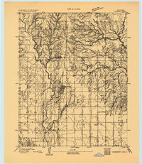 1893 Hennessey1893 Print · USGSOklahoma Territory is captured during its formative years of settlement as the iron rail connects the prairie to the wider world. Genealogists and historians can trace the early foundations of Hennessey or locate smaller, early outposts like Buffalo Springs, Paris, and Myrtle.
 - 1893 Map of Loyal
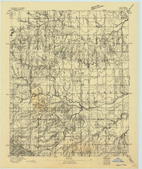 1893 Loyal1893 Print · USGSOklahoma Territory was still in its first decade of settlement when these early communities began to dot the landscape. Researchers can trace the original locations of Omega, Alpha, and Huntsville alongside the borders of the Cheyenne and Arapahoe Reservation.2 unique versions available
 - 1893 Map of Ames
 1893 Ames1893 Print · USGSOklahoma territory is captured here during the early surveying era, showing the river-dominated landscape of Major and Kingfisher counties. Local historians can trace early settlement patterns at Lacey and Parvin or locate the historic Washburns Crossing on the Cimarron River.2 unique versions available
 - 1895 Map of Kingfisher
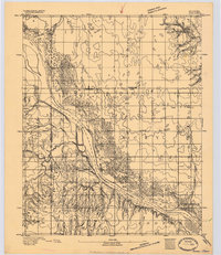
 1895 Kingfisher1895 Print · USGSOklahoma Territory during the mid-1890s reveals a rapidly developing frontier defined by river crossings and expanding rail lines. Genealogists and historians can trace the early foundations of Kingfisher, Elreno, and Yukon alongside historic river crossings like Gould Ford.4 unique versions available
End of results
Showing maps 1-7 of 7
Top cities of Kingfisher County
Frequently asked questions
- What are the different types of historical maps available for Kingfisher County?
- What is the oldest map of Kingfisher County?
- Where can I purchase historical maps of Kingfisher County for my home or office?
- Where can I download high-res historical maps of Kingfisher County?
- Are there historical topographic maps available for Kingfisher County?
- Is there historical aerial imagery available for Kingfisher County?
- Where are historical maps of Kingfisher County sourced from?