1990s Maps of Marion County, Oregon
Explore 17 historic maps of Marion County from the 1990s. These maps offer a rare glimpse into what life looked like during the 1990s — showing old roads, neighborhoods, homes, and landmarks that have changed or disappeared over time.
Whether you're researching your family's past, planning a metal detecting trip, or studying how Marion County's landscape evolved across the 1990s, these high-resolution maps are a powerful tool for exploring the history of this region.
- Focus on a specific era: All maps on this page are from the 1990s, giving you a focused view of this time period.
- See what’s changed: Compare century-old streets, trails, and buildings to today's modern landscape using overlays and satellite layers.
- Research with precision: Use these maps for genealogy, historical research, land use analysis, or educational projects.
- View, download, or print: Maps are fully viewable online in high resolution, and can be downloaded or printed for your own records.
Start exploring Marion County's history through authentic maps from the 1990s. This is your window into the past.
Marion County, OR maps
(17)- 1991 Map of North Santiam River, 1993 Print
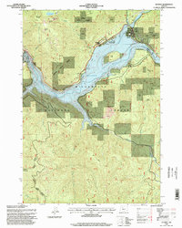
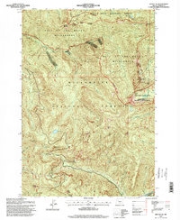
 1991 North Santiam River1993 Print · USGSMarion and Linn counties come into focus in the early 1990s as the Santiam River valley transitions from the Willamette Valley floor to the Cascade peaks. Researchers can trace timber and rail history through Mill City, locate family landmarks near Stayton, or explore the boundaries of Silver Falls State Park.
 - 1994 Map of Detroit, 1998 Print
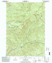
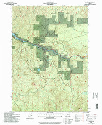
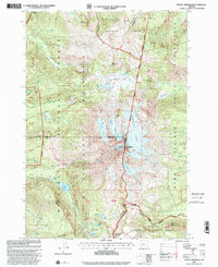
 1994 Detroit1998 Print · USGSIn the mid-1990s, the North Santiam canyon was a hub of water management and forest activity centered around the high-elevation reservoir. Historians can trace the development of Detroit and find the location of the Detroit Dam, Detroit Lake State Park, and the smaller settlement of Sparton.
 - 1994 Map of Mother Lode Mtn, 1998 Print
 1994 Mother Lode Mtn1998 Print · USGSMarion County high country in the mid-1990s is captured here at the intersection of two National Forests. Researchers can trace resource history and recreational access through landmarks like the Gold Butte Lookout, the Breitenbush River, and Mother Lode Mountain.
 - 1994 Map of Lawhead Creek, 1998 Print
 1994 Lawhead Creek1998 Print · USGSThe Cascade foothills of Linn County appear in the mid-1990s as a landscape of timber management and recreation. You can trace the rugged topography from Monument Peak down to the Detroit Lake Reservoir, or locate remote access points near Lawhead Creek and Potato Hill.
 - 1994 Map of Mount Bruno, 1998 Print
 1994 Mount Bruno1998 Print · USGSMarion and Linn counties meet in the high Cascades during the mid-nineties, where the North Santiam River divides the national forest. Hikers and historians can trace backcountry routes past McCoy Shelter, Bruno Lakes, and the heights of Mount Bruno.
 - 1994 Map of Battle Ax, 1998 Print
 1994 Battle Ax1998 Print · USGSMarion County's high Cascades are shown in the 1990s, where federal wilderness boundaries meet in a landscape of sharp ridges and mountain lakes. You can locate remote geological features like Phantom Natural Bridge or trace historical forest paths including the Whetstone Trail and Twin Lake Trail.
 - 1994 Map of Elkhorn, 1998 Print
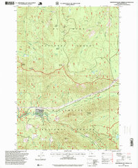
 1994 Elkhorn1998 Print · USGSThe North Santiam river corridor in the mid-1990s reveals a landscape of high timber country and riverfront settlements. Researchers can trace the layout of small communities like Elkhorn, Niagara, and Minto, alongside landmarks such as the Niagara Dam and Rocky Top.
 - 1994 Map of Idanha, 1998 Print
 1994 Idanha1998 Print · USGSThe mountain settlement of Idanha and the upper reaches of Detroit Lake are captured here during the mid-1990s. Researchers can trace the river-valley economy through local landmarks like the Gaging Station, Whispering Falls, and the Santiam State Forest.
 - 1996 Map of Fort Butte, 1998 Print
 1996 Fort Butte1998 Print · USGSHigh in the Cascade Range during the late nineties, this landscape spans the border of the Warm Springs Indian Reservation. Hikers and historians can trace the Pacific Crest National Scenic Trail past Fort Butte and the springs of Camas Prairie.
 - 1997 Map of Rooster Rock, 1999 Print
 1997 Rooster Rock1999 Print · USGSThe northern Cascades come into focus in the late nineties, where the high ridges of the Clackamas and Marion county line meet. Researchers can trace the drainage of the Molalla River and locate historic sites like the Ogle Mtn Mine and Peshuck Lookout.
 - 1997 Map of Pinhead Buttes, 1999 Print
 1997 Pinhead Buttes1999 Print · USGSThe high Cascade ridgelines between Clackamas and Wasco counties are captured here in the late nineties. Modern researchers can trace the Pacific Crest Nat Scenic Trail as it passes landmarks like the Sisi Lookout and Warm Springs Cabin.
 - 1997 Map of Bagby Hot Springs, 1999 Print
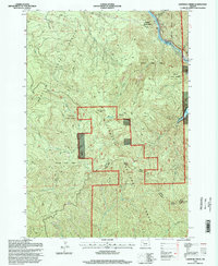
 1997 Bagby Hot Springs1999 Print · USGSClackamas and Marion counties are captured here in the late nineties, documenting the remote mountain landscape of the Cascades. Researchers can trace the trails around Bagby Hot Springs and locate landmarks like Baty Butte or the Hugh Creek Quarry.
 - 1997 Map of Bull of the Woods, 1999 Print
 1997 Bull of the Woods1999 Print · USGSHigh in the Cascades during the late 1990s, this area shows a landscape defined by industrial forestry and protected wilderness. Researchers can trace forest resource sites like the Happy Quarry and remote landmarks such as the Bull of the Woods Lookout.
 - 1997 Map of Breitenbush Hot Springs, 1999 Print
 1997 Breitenbush Hot Springs1999 Print · USGSThe Oregon Cascades in the late nineties reveal a landscape of geothermal springs and remote forest outposts. You can trace the trails and infrastructure surrounding Breitenbush Hot Springs, including the Powerhouse and the nearby Breitenbush Guard Station.
 - 1997 Map of Mount Lowe, 1999 Print
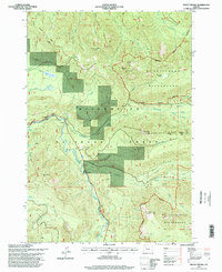
 1997 Mount Lowe1999 Print · USGSThe northern Cascades in the late nineties are defined here by high ridgelines and forest management. Researchers can trace the drainages of the Clackamas River, locate high-country clearings like Jim Meadow, and identify resource sites such as Squirrel Quarry.
 - 1997 Map of Olallie Butte, 1999 Print
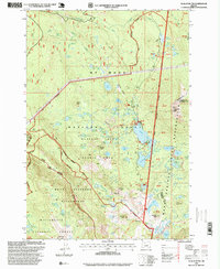 1997 Olallie Butte1999 Print · USGSThe High Cascades come into focus during the late nineties, where three counties and two national forests meet. Outdoor enthusiasts and researchers can trace the shores of Olallie Lake, locate the Ruddy Hill Quarry, or follow the Warm Springs Indian Reservation boundary.
 - 1997 Map of Mount Jefferson, 2001 Print
 1997 Mount Jefferson2001 Print · USGSThe high Cascade crest at Mount Jefferson comes into sharp focus during the late 1990s, where three counties and several national forests converge. Hikers and researchers can trace the Pacific Crest National Scenic Trail past Whitewater Glacier and remote alpine basins like Hunts Cove.
End of results
Showing maps 1-17 of 17
Top cities of Marion County
- Salem historical maps
- Keizer historical maps
- Woodburn historical maps
- Silverton historical maps
- Stayton historical maps
- Mount Angel historical maps
See more
Frequently asked questions
- What are the different types of historical maps available for Marion County?
- What is the oldest map of Marion County?
- Where can I purchase historical maps of Marion County for my home or office?
- Where can I download high-res historical maps of Marion County?
- Are there historical topographic maps available for Marion County?
- Is there historical aerial imagery available for Marion County?
- Where are historical maps of Marion County sourced from?