1900s (20th Century) Maps of Hamilton County, Tennessee
Explore 107 historic maps of Hamilton County from the 1900s (20th Century). These maps offer a rare glimpse into what life looked like during the 1900s — showing old roads, neighborhoods, homes, and landmarks that have changed or disappeared over time.
Whether you're researching your family's past, planning a metal detecting trip, or studying how Hamilton County's landscape evolved across the 1900s, these high-resolution maps are a powerful tool for exploring the history of this region.
- Focus on a specific era: All maps on this page are from the 1900s, giving you a focused view of this time period.
- See what’s changed: Compare century-old streets, trails, and buildings to today's modern landscape using overlays and satellite layers.
- Research with precision: Use these maps for genealogy, historical research, land use analysis, or educational projects.
- View, download, or print: Maps are fully viewable online in high resolution, and can be downloaded or printed for your own records.
Start exploring Hamilton County's history through authentic maps from the 1900s. This is your window into the past.
Hamilton County, TN maps
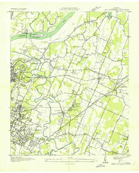
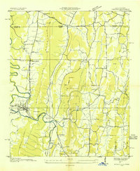
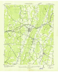
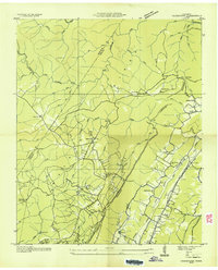
(107)- 1901 Map of Cleveland
 1901 Cleveland1901 Print · USGSSoutheast Tennessee was a thriving hub of river and rail commerce at the dawn of the twentieth century. Genealogists can trace family homesteads near vanished landmarks like Marble Switch, Bunker Hill Ferry, or the early settlements of Riceville and Benton.4 unique versions available
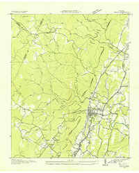
 - 1935 Map of East Chattanooga
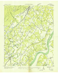
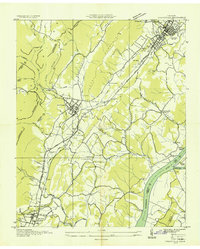
 1935 East Chattanooga1935 Print · USGSHamilton County is captured during the mid-1930s as the Tennessee Valley Authority begins its massive hydroelectric projects. Researchers can locate family landmarks like Bartlebaugh Cem, the Silverdale community, and the construction site of the Chickamauga Dam.
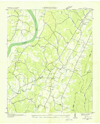
 - 1935 Map of Daisy
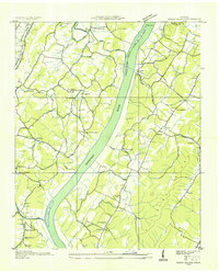
 1935 Daisy1935 Print · USGSHamilton County communities thrive along the Tennessee River in the mid-1930s, just as the Tennessee Valley Authority began its regional transformation. Genealogists and local historians can trace family homesteads near Poe Cem, Hixson Mill, and the Harrison Ferry crossing.
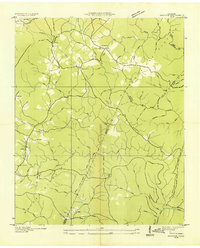
 - 1935 Map of Mc Donald
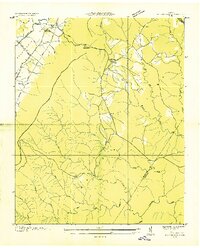
 1935 Mc Donald1935 Print · USGSDuring the mid-1930s, the rural Bradley County landscape was a network of ridge-top schools and valley rail stops. Researchers can trace family sites like Goats Chapel, the industry of Grumgoof Mill, and old settlements at Black Fox or Marble Switch.
 - 1935 Map of East Ridge
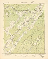
 1935 East Ridge1935 Print · USGSThe Georgia-Tennessee borderlands appear here in the mid-1930s, showing the intersection of military history and rural development. You can trace the early layout of East Ridge and locate family landmarks like Lomemick Cem, Burning Bush Sch, and Boynton.
 - 1935 Map of Tiger Creek
 1935 Tiger Creek1935 Print · USGSThe Tennessee and Georgia borderlands meet along the ridges of Whitfield and Catoosa counties in the mid-1930s. Genealogists and historians can trace family land along Tiger Creek and locate the Southern railroad crossing at White Cut.
 - 1935 Map of Ringgold
 1935 Ringgold1935 Print · USGSThe Georgia-Tennessee borderlands in the mid-1930s are anchored by the town of Ringgold and the central Military Reservation. Genealogists and historians can trace community roots at Salem Ch, Ebenezer Ch, and the rural Union Academy.
 - 1935 Map of Soddy
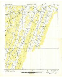
 1935 Soddy1935 Print · USGSThe Cumberland Escarpment meets the industrial valley floor north of Chattanooga in the mid-1930s. Researchers can trace family roots at Hotwater Cem or locate the old Rathburn Station along the Southern Railway.
 - 1935 Map of Snow Hill
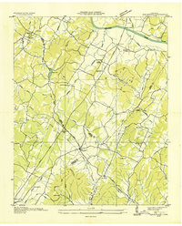
 1935 Snow Hill1935 Print · USGSHamilton County in the mid-1930s was a landscape of ridge-and-valley farms and small riverfront communities. Genealogists and local historians can trace family locations through numerous sites like Norman Cem, Maddox Sch, and Scoggins Mill.
 - 1935 Map of Brayton
 1935 Brayton1935 Print · USGSWalden Ridge was undergoing a rapid transformation in the mid-1930s as new electrical infrastructure reached into the plateau settlements. Researchers can locate the Brayton Sch, Hickory Grove Cem, and long-standing family locations like Hendon and McGill.2 unique versions available
 - 1935 Map of Ooltewah
 1935 Ooltewah1935 Print · USGSHamilton County's ridge-and-valley landscape is documented here in the mid-1930s as rural life centered on the rail lines and mountain gaps. Genealogists and historians can trace family roots at Ooltewah Cem, locate the early campus of Southern Junior College, or find the old Rogers Mill.
 - 1935 Map of Birchwood
 1935 Birchwood1935 Print · USGSSoutheastern Tennessee rural life is documented here during the mid-1930s as the regional power grid began to expand across the ridges. Genealogists can trace early homesteads near Georgetown, Birchwood, and country landmarks like St Elmo Sch or New Union Ch.
 - 1935 Map of Big Spring
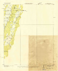
 1935 Big Spring1935 Print · USGSThe Tennessee and Hiwassee rivers define the landscape in the mid-thirties, when ferries were the primary links between Meigs and Rhea counties. Genealogists can trace family roots through labels for Big Spring, Salem Ch, and the Garrison Cem.
 - 1935 Map of South Cleveland
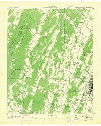 1935 South Cleveland1935 Print · USGSSoutheast Tennessee in the mid-1930s is defined here by its ridge-and-valley landscape and rural crossroads. Genealogists and historians can locate family landmarks like Trues Chapel Cem, the Pentecostal Orphans Home, and Norman Chapel Sch.
 - 1935 Map of Soddy Island
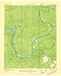
 1935 Soddy Island1935 Print · USGSHamilton County communities along the Tennessee River are shown here in the mid-1930s just as TVA development began. Researchers can trace rural life through landmarks like Mt Tabor Community, Bakewell Sch, and the Bald Hill Cem near the riverbanks.
 - 1935 Map of Graysville
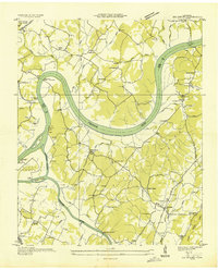
 1935 Graysville1935 Print · USGSRhea and Hamilton counties are shown in detail during the mid-1930s, caught between the ridge-and-valley terrain and the river. Genealogists can locate family landmarks like Welch Cem, trace the historic Blythe Ferry, or find CCC Camp No 3470.
 - 1936 Map of Henson Gap
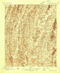
 1936 Henson Gap1936 Print · USGSThe Tennessee highlands near Henson Gap are captured in the mid-1930s as the TVA modernization began to reach these rural ridges. Genealogists and local historians can trace family land near Lewis Chapel Sch, Davis Chapel Ch, and the banks of Soddy Creek.
 - 1936 Map of Ketner Gap
 1936 Ketner Gap1936 Print · USGSMarion and Sequatchie counties appear in the mid-1930s as a landscape of isolated coal mines and ridge-top gaps. Genealogists and historians can trace family locations through Grayson Cem, Sulphur Springs Sch, and the industrial sites at Barnes Mine.
 - 1936 Map of Hooker
 1936 Hooker1936 Print · USGSNorthwest Georgia and neighboring Tennessee appear here in the mid-thirties, showing a landscape defined by mountain gaps and river valleys. Researchers can trace the path of Southern Railway through Morganville or locate family sites like Bethlehem Cem and Slygo Ch.
 - 1936 Map of Fort Oglethorpe
 1936 Fort Oglethorpe1936 Print · USGSThe Georgia-Tennessee borderlands appear here in the mid-1930s, featuring the extensive grounds of the Chickamauga battlefield and the early development of Lookout Mountain. Researchers can locate historic farmsteads and monuments such as the Snodgrass House, the Lee and Gordon Mill, and Rock City Gardens.
 - 1936 Map of Fairmount
 1936 Fairmount1936 Print · USGSThe plateau communities of Walden Ridge are captured here in the mid-1930s as modern infrastructure reached these mountain settlements. Genealogists can trace family footprints through numerous landmarks like Sawyer Cem, Fairmount Sch, and Union Springs Ch.
 - 1936 Map of Wauhatchie
 1936 Wauhatchie1936 Print · USGSThe Tennessee River gorge comes alive in this mid-1930s survey of the Marion and Hamilton county line during the early TVA era. Genealogists can trace family landmarks like French Cem and Mc Nabb Cem, or locate industry at Aetna and several Mines (Abandoned).
 - 1936 Map of Chattanooga
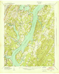
 1936 Chattanooga1936 Print · USGSChattanooga and the Tennessee River are shown here in the mid-thirties as the river valley underwent massive transformation. Trace the historic street grid and landmarks like the Incline Railway, National Cem, and Moccasin Bend.
 - 1938 Map of Chatsworth
 1938 Chatsworth1938 Print · USGSMurray and Whitfield counties in the late 1930s show a landscape of river-crossing culture and early aviation infrastructure. Researchers can locate family landmarks like Praters Mill, rural schools such as Deep Springs Sch, and historic river points including Harris Ford.3 unique versions available
 - 1939 Map of Soddy Island
 1939 Soddy Island1939 Print · USGSAs the Tennessee Valley Authority reshaped the landscape in the late thirties, this area was caught between its rural past and a new era of hydroelectric power. Trace family roots and submerged landmarks through Bakewell, Thatcher Cem, and the winding Birchwood Pike.4 unique versions available
Showing maps 1-25 of 107
Top cities of Hamilton County
- Chattanooga historical maps
- East Ridge historical maps
- Soddy-Daisy historical maps
- Collegedale historical maps
- Signal Mountain historical maps
- Walden historical maps
See more
Frequently asked questions
- What are the different types of historical maps available for Hamilton County?
- What is the oldest map of Hamilton County?
- Where can I purchase historical maps of Hamilton County for my home or office?
- Where can I download high-res historical maps of Hamilton County?
- Are there historical topographic maps available for Hamilton County?
- Is there historical aerial imagery available for Hamilton County?
- Where are historical maps of Hamilton County sourced from?