1960s Maps of Hamilton County, Tennessee
Explore 17 historic maps of Hamilton County from the 1960s. These maps offer a rare glimpse into what life looked like during the 1960s — showing old roads, neighborhoods, homes, and landmarks that have changed or disappeared over time.
Whether you're researching your family's past, planning a metal detecting trip, or studying how Hamilton County's landscape evolved across the 1960s, these high-resolution maps are a powerful tool for exploring the history of this region.
- Focus on a specific era: All maps on this page are from the 1960s, giving you a focused view of this time period.
- See what’s changed: Compare century-old streets, trails, and buildings to today's modern landscape using overlays and satellite layers.
- Research with precision: Use these maps for genealogy, historical research, land use analysis, or educational projects.
- View, download, or print: Maps are fully viewable online in high resolution, and can be downloaded or printed for your own records.
Start exploring Hamilton County's history through authentic maps from the 1960s. This is your window into the past.
Hamilton County, TN maps
(17)- 1960 Map of Chattanooga
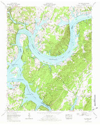
 1960 Chattanooga1960 Print · USGSSoutheast Tennessee and the southern Appalachians are shown here at the height of the river-management era. You can trace the valley rail lines and locate Lookout Mountain and the expansive waters of Chickamauga Reservoir.
 - 1960 Map of Cohutta, 1962 Print
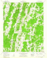 1960 Cohutta1962 Print · USGSWhitfield County and the Georgia-Tennessee border are detailed here in the early sixties, showing a landscape of forest ridges and rail-side towns. Genealogists can locate family landmarks like Prater Mill, South Cohutta Ch, and the Hoskins Cem.3 unique versions available
 - 1961 Map of Rome
 1961 Rome1961 Print · USGSNorthwest Georgia and neighboring Tennessee and Alabama are shown here at a moment of significant mid-century growth. Researchers can trace the rail networks of the Central of Georgia or locate landmarks within Chickamauga and Chattanooga Nat Military Park.
 - 1963 Map of Rome
 1963 Rome1963 Print · USGSThe tri-state corner of Georgia, Alabama, and Tennessee is captured here during a period of massive reservoir expansion and post-war growth. Genealogists and historians can trace the rail corridors of the Southern Ry or locate landmarks like Fort Oglethorpe and Cloudland Canyon State Park.
 - 1964 Map of Chattanooga
 1964 Chattanooga1964 Print · USGSSoutheast Tennessee and the western Carolinas appear in the mid-sixties as a powerhouse of river-driven industry and mountain wilderness. Genealogists and historians can trace rail-town lineages along the Southern Ry or locate family landmarks near Watts Bar Lake and Tellico Plains.
 - 1964 Map of Snow Hill, 1966 Print
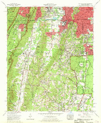
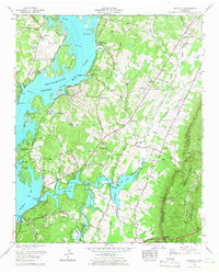 1964 Snow Hill1966 Print · USGSHamilton County in the mid-sixties reveals a landscape transformed by the Tennessee River and the growth of recreational spaces. Researchers can trace family history through numerous rural burial sites like Roddy-Yarnell Cem and landmarks such as the Wolftever Fishing Club or Jones Airfield.2 unique versions available
 - 1964 Map of Ooltewah, 1966 Print
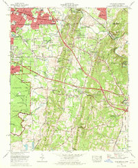
 1964 Ooltewah1966 Print · USGSHamilton County in the mid-sixties reveals a landscape balancing its military history with growing educational and rail hubs. Researchers can trace family-named cemeteries such as Sylar Cemetery and Plowman Cemetery or locate landmarks like Bell Mill and the Southern Missionary College.4 unique versions available
 - 1965 Map of South Cleveland, 1966 Print
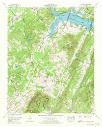
 1965 South Cleveland1966 Print · USGSSoutheast Tennessee is captured here in the mid-sixties as the suburbs of Cleveland began to reach toward White Oak Mountain. Researchers can trace family history through sites like Seaborn Cem, Hopewell Sch, and the Bachman Memorial Childrens Home.2 unique versions available
 - 1967 Map of Big Spring, 1969 Print
 1967 Big Spring1969 Print · USGSThe Tennessee and Hiwassee rivers converge in this mid-century survey of Rhea and Meigs counties, highlighting a landscape of river meanders and conservation areas. Researchers can trace family history at Shaver Cem, locate the William Jennings Bryan University campus, or find the riverside Indian mound.3 unique versions available
 - 1967 Map of Birchwood, 1970 Print
 1967 Birchwood1970 Print · USGSThe Tennessee Valley in the late 1960s shows a landscape defined by the ridges of White Oak Mountain and the rising waters of Chickamauga Lake. Genealogists can trace family names at Hinkle Cemetery and Francisco Cem or locate the old Meadowview Sch.
 - 1967 Map of Mc Donald, 1970 Print
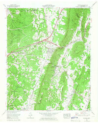
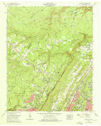
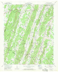 1967 Mc Donald1970 Print · USGSBradley and Hamilton counties during the late sixties are captured here in meticulous detail, showing the rural communities between the ridges. Researchers can trace family sites near McDonald, Bethel Ch, and the Lee Cem while following old railroad spurs at Marble Switch.3 unique versions available
 - 1969 Map of Chattanooga
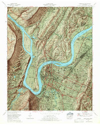 1969 Chattanooga1969 Print · USGSChattanooga and the Tennessee River valley are captured in the late sixties as new interstate construction began to cut through the city's historic core. Trace the layout of the National Cemetery, the rail lines at Cravens Yards, and the unique development of Moccasin Bend.6 unique versions available
 - 1969 Map of Fort Oglethorpe, 1970 Print
 1969 Fort Oglethorpe1970 Print · USGSThe Georgia-Tennessee borderlands south of Chattanooga come into focus in the late sixties, showing the suburban expansion and military heritage of the region. Researchers can trace family roots through Humphreys Cem, locate the Chattanooga Valley High School, or study the grounds of Chickamauga and Chattanooga National Military Park.
 - 1969 Map of East Ridge, 1970 Print
 1969 East Ridge1970 Print · USGSThe Tennessee-Georgia borderlands are captured here in the late sixties as suburban expansion meets Civil War history. Genealogists can trace family landmarks like Lomenick Cem, Spring Creek Church, and the original path of the Dixie Highway.2 unique versions available
 - 1969 Map of East Chattanooga, 1970 Print
 1969 East Chattanooga1970 Print · USGSHamilton County enters a period of post-war suburban and industrial growth as the Chattanooga city limits expand toward the Tennessee River. Genealogists and historians can trace family locations near Stubblefield Cem, Bonny Oaks Sch, and the Volunteer Army Ammunition Plant.5 unique versions available
 - 1969 Map of Daisy, 1972 Print
 1969 Daisy1972 Print · USGSHamilton County experienced significant growth along the Tennessee River during the late sixties as older settlements met new suburban expansion. Genealogists and historians can trace family roots through sites like John H Allen School, the Old Mill, and numerous local burial grounds including Hensley Cem.
 - 1969 Map of Fairmount, 1972 Print
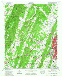
 1969 Fairmount1972 Print · USGSHamilton County uplands and the Chattanooga valley come into focus during the late sixties as suburban growth climbs the ridges. Trace family history through Sawyer Cem and Brown Chapel Cem, or locate landmarks like the Wines T Thrasher School and Falling Water Falls.5 unique versions available
End of results
Showing maps 1-17 of 17
Top cities of Hamilton County
- Chattanooga historical maps
- East Ridge historical maps
- Soddy-Daisy historical maps
- Collegedale historical maps
- Signal Mountain historical maps
- Walden historical maps
See more
Frequently asked questions
- What are the different types of historical maps available for Hamilton County?
- What is the oldest map of Hamilton County?
- Where can I purchase historical maps of Hamilton County for my home or office?
- Where can I download high-res historical maps of Hamilton County?
- Are there historical topographic maps available for Hamilton County?
- Is there historical aerial imagery available for Hamilton County?
- Where are historical maps of Hamilton County sourced from?