1970s Maps of Hamilton County, Tennessee
Explore 8 historic maps of Hamilton County from the 1970s. These maps offer a rare glimpse into what life looked like during the 1970s — showing old roads, neighborhoods, homes, and landmarks that have changed or disappeared over time.
Whether you're researching your family's past, planning a metal detecting trip, or studying how Hamilton County's landscape evolved across the 1970s, these high-resolution maps are a powerful tool for exploring the history of this region.
- Focus on a specific era: All maps on this page are from the 1970s, giving you a focused view of this time period.
- See what’s changed: Compare century-old streets, trails, and buildings to today's modern landscape using overlays and satellite layers.
- Research with precision: Use these maps for genealogy, historical research, land use analysis, or educational projects.
- View, download, or print: Maps are fully viewable online in high resolution, and can be downloaded or printed for your own records.
Start exploring Hamilton County's history through authentic maps from the 1970s. This is your window into the past.
Hamilton County, TN maps
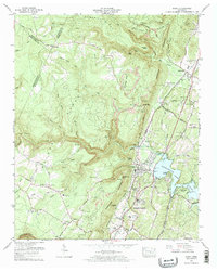
(8)- 1970 Map of Hooker, 1972 Print
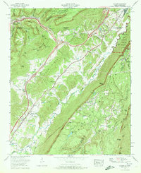 1970 Hooker1972 Print · USGSThe Tennessee-Georgia borderlands come to life in the early seventies, where the massive profiles of Lookout Mountain and Raccoon Mountain meet. Genealogists and local historians can trace family-named sites like Bates Cem, Sarah Chapel, and the small community of New England.
 - 1970 Map of Wauhatchie, 1972 Print
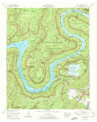 1970 Wauhatchie1972 Print · USGSThe Tennessee River loops around Raccoon Mountain during the early seventies as new energy infrastructure begins to reshape the riverbank. Genealogists and hikers can trace family sites like McNabb Cem or explore landmarks such as Crystal Cave and Suck Shoals.3 unique versions available
 - 1972 Map of Graysville, 1974 Print
 1972 Graysville1974 Print · USGSRhea County at the start of the seventies shows a landscape defined by the towering Cumberland Escarpment and the river life of the Hiwassee River. Genealogists and historians can trace family locations through numerous small burial grounds like Lone Mtn Cem and rural school sites such as College Hill Sch.4 unique versions available
 - 1972 Map of Grasshopper Creek, 1974 Print
 1972 Grasshopper Creek1974 Print · USGSNear the Hamilton and Meigs county line in the early seventies, the Tennessee Valley Authority documented the developed shoreline of the Tennessee River. Genealogists can trace family landmarks like the Bakewell Sch, Dolly Pond Cem, and Mt Annie Church.
 - 1972 Map of Soddy, 1974 Print
 1972 Soddy1974 Print · USGSThe Cumberland plateau meets the shoreline of Chickamauga Lake in the early seventies as the industry of Soddy-Daisy expands. Trace family roots at Granny Walker Cem or locate the old Mowbray School and Hotwater Cem.2 unique versions available
 - 1972 Map of Brayton, 1974 Print
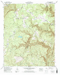 1972 Brayton1974 Print · USGSThe Cumberland plateau in the early seventies shows a landscape of small Tennessee mountain communities and active industry. Genealogists can locate family names at Metz Cem and Hendon Cem or trace the early footprint of Smithtown and Brayton.2 unique versions available
 - 1976 Map of Daisy, 1977 Print
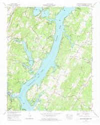
 1976 Daisy1977 Print · USGSHamilton County experienced rapid suburban growth in the mid-seventies as new subdivisions spread toward the banks of Chickamauga Lake. Genealogists and historians can trace family landmarks like Harris Cem and Jackson Chapel Cem or locate industrial sites like Greens Mill.2 unique versions available
 - 1979 Map of Chattanooga, 1980 Print
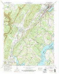
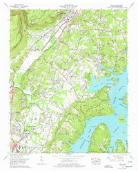
 1979 Chattanooga1980 Print · USGSSoutheast Tennessee in the late seventies reveals a landscape shaped by massive TVA river projects and the industrial strength of the Cumberland Plateau. Genealogists and historians can trace the rail-to-river network through L & N RR junctions, the University of the South, and the Volunteer Army Ammunition Plant.
End of results
Showing maps 1-8 of 8
Top cities of Hamilton County
- Chattanooga historical maps
- East Ridge historical maps
- Soddy-Daisy historical maps
- Collegedale historical maps
- Signal Mountain historical maps
- Walden historical maps
See more
Frequently asked questions
- What are the different types of historical maps available for Hamilton County?
- What is the oldest map of Hamilton County?
- Where can I purchase historical maps of Hamilton County for my home or office?
- Where can I download high-res historical maps of Hamilton County?
- Are there historical topographic maps available for Hamilton County?
- Is there historical aerial imagery available for Hamilton County?
- Where are historical maps of Hamilton County sourced from?