1980s Maps of Hamilton County, Tennessee
Explore 10 historic maps of Hamilton County from the 1980s. These maps offer a rare glimpse into what life looked like during the 1980s — showing old roads, neighborhoods, homes, and landmarks that have changed or disappeared over time.
Whether you're researching your family's past, planning a metal detecting trip, or studying how Hamilton County's landscape evolved across the 1980s, these high-resolution maps are a powerful tool for exploring the history of this region.
- Focus on a specific era: All maps on this page are from the 1980s, giving you a focused view of this time period.
- See what’s changed: Compare century-old streets, trails, and buildings to today's modern landscape using overlays and satellite layers.
- Research with precision: Use these maps for genealogy, historical research, land use analysis, or educational projects.
- View, download, or print: Maps are fully viewable online in high resolution, and can be downloaded or printed for your own records.
Start exploring Hamilton County's history through authentic maps from the 1980s. This is your window into the past.
Hamilton County, TN maps
(10)- 1980 Map of Snow Hill
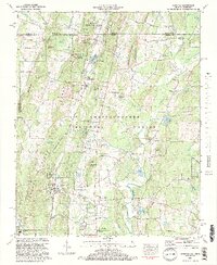
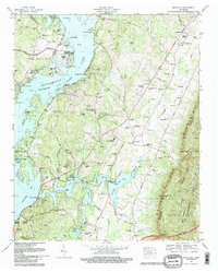 1980 Snow Hill1980 Print · USGSHamilton County was entering a new era of energy production and suburban growth during the late seventies. Family historians and researchers can trace dozens of rural burial sites like Roddy-Yarnell Cem alongside the rising Sequoyah Nuclear Plant and the developing Lakesite community.2 unique versions available
 - 1981 Map of Cleveland
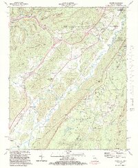
 1981 Cleveland1981 Print · USGSSoutheast Tennessee and Western North Carolina are documented here in the early eighties, as the Tennessee Valley Authority managed the region's vast river and forest resources. Researchers can trace the rail lines of the Southern and Louisville and Nashville or locate industrial sites in the Copper Basin and settlements like Ducktown.2 unique versions available
 - 1981 Map of Chickamauga, 1982 Print
 1981 Chickamauga1982 Print · USGSThe tri-state border region of Georgia, Alabama, and Tennessee comes into focus during the early eighties, defined by the towering ridges of the Appalachians. Historians can trace the preserved grounds of Chickamauga and Chattanooga National Military Park and old rail stops like Rising Fawn or Sulphur Springs.2 unique versions available
 - 1981 Map of Dalton, 1982 Print
 1981 Dalton1982 Print · USGSNorth Georgia and the tristate borderlands are captured in the early eighties as the textile economy of Dalton thrived alongside the expanding Chattahoochee National Forest. Genealogists and hikers can trace the Appalachian Trail through the high country or locate family-named landmarks like Haskins Mill and Carters Mill.
 - 1982 Map of Hooker, 1983 Print
 1982 Hooker1983 Print · USGSThe northern reaches of Georgia's mountain country are captured here in the early eighties, where deep valleys and rail lines define the settlements. Genealogists can trace family names through numerous landmarks like Haswell Cem, Slygo Ch, and New England.2 unique versions available
 - 1982 Map of Fort Oglethorpe, 1983 Print
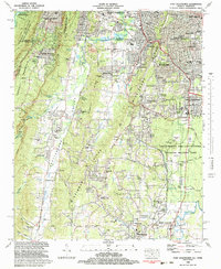 1982 Fort Oglethorpe1983 Print · USGSThe Georgia-Tennessee borderlands in the early eighties show a landscape deeply shaped by Civil War history and post-war growth. Researchers can trace family sites and local landmarks from Lookout Mountain to the Lee and Gordon Mill, including the Wilder Obsv Tower and Brotherton House.3 unique versions available
 - 1982 Map of East Ridge, 1983 Print
 1982 East Ridge1983 Print · USGSThe Tennessee-Georgia borderlands come into focus in the early eighties as suburban growth meets preserved Civil War grounds. Genealogists and historians can locate old family plots and rural landmarks like Dietz Cem, Swanson Mill, and the Shiloh Ch.2 unique versions available
 - 1982 Map of Cohutta, 1984 Print
 1982 Cohutta1984 Print · USGSCrossing the Tennessee border into North Georgia in the early eighties, this survey captures the rural character of Whitfield County. Genealogists and local historians can trace family-named sites like Goode Cem and landmarks such as Prater Mill and McGaughey Lookout Tower.2 unique versions available
 - 1983 Map of Ringgold
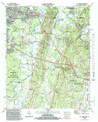
 1983 Ringgold1983 Print · USGSCatoosa County is captured in the early eighties as the interstate age began to reshape the historic landscape around Ringgold. Researchers can trace old family names and community foundations at Lee Chapel, Shookville, and the Catoosa Consolidated Sch.3 unique versions available
 - 1988 Map of Chattanooga, 1991 Print
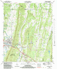
 1988 Chattanooga1991 Print · USGSSoutheast Tennessee at the end of the 1980s reveals a complex landscape of deep river valleys and high coal-rich plateaus. Researchers can trace the legacy of the L & N RR through Tracy City or locate the sprawling Strip Mines near Whitwell.
End of results
Showing maps 1-10 of 10
Top cities of Hamilton County
- Chattanooga historical maps
- East Ridge historical maps
- Soddy-Daisy historical maps
- Collegedale historical maps
- Signal Mountain historical maps
- Walden historical maps
See more
Frequently asked questions
- What are the different types of historical maps available for Hamilton County?
- What is the oldest map of Hamilton County?
- Where can I purchase historical maps of Hamilton County for my home or office?
- Where can I download high-res historical maps of Hamilton County?
- Are there historical topographic maps available for Hamilton County?
- Is there historical aerial imagery available for Hamilton County?
- Where are historical maps of Hamilton County sourced from?