1950s Maps of Hamilton County, Tennessee
Explore 11 historic maps of Hamilton County from the 1950s. These maps offer a rare glimpse into what life looked like during the 1950s — showing old roads, neighborhoods, homes, and landmarks that have changed or disappeared over time.
Whether you're researching your family's past, planning a metal detecting trip, or studying how Hamilton County's landscape evolved across the 1950s, these high-resolution maps are a powerful tool for exploring the history of this region.
- Focus on a specific era: All maps on this page are from the 1950s, giving you a focused view of this time period.
- See what’s changed: Compare century-old streets, trails, and buildings to today's modern landscape using overlays and satellite layers.
- Research with precision: Use these maps for genealogy, historical research, land use analysis, or educational projects.
- View, download, or print: Maps are fully viewable online in high resolution, and can be downloaded or printed for your own records.
Start exploring Hamilton County's history through authentic maps from the 1950s. This is your window into the past.
Hamilton County, TN maps
(11)- 1953 Map of Chattanooga
 1953 Chattanooga1953 Print · USGSSoutheast Tennessee in the early fifties shows a landscape reshaped by river management and rail power. Trace the rail lines of the Southern Ry through riverside towns or locate the preserved grounds of the Chickamauga and Chattanooga National Military Park.
 - 1955 Map of Rome
 1955 Rome1955 Print · USGSThe tri-state borderlands of Georgia, Alabama, and Tennessee appear in the mid-fifties as a landscape of ridge-and-valley industry and river navigation. Genealogists can trace family footprints near Chattanooga, the iron works of Gadsden, and textile towns like Trion or Summerville.
 - 1957 Map of Chattanooga, 1966 Print
 1957 Chattanooga1966 Print · USGSEast Tennessee in the mid-1960s shows a landscape of massive hydroelectric reservoirs and emerging industrial sites like the Atomic Energy Commission (Oak Ridge Area). Trace the rail networks of the Southern Ry through Chattanooga or locate family-named ridges across the Cumberland Plateau.3 unique versions available
 - 1958 Map of Daisy, 1959 Print
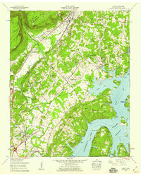 1958 Daisy1959 Print · USGSHamilton County experienced significant post-war development along the reservoir in the late fifties, blending rural crossroads with new recreational spaces. Genealogists and locals can trace family names at Foster Hixson Cem, Daisy, and the John H Allen Sch.2 unique versions available
 - 1958 Map of Chattanooga, 1959 Print
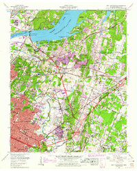
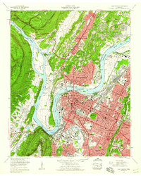 1958 Chattanooga1959 Print · USGSChattanooga and the Tennessee River valley are shown in the late fifties at a peak of industrial and suburban development. Genealogists and historians can trace family names at Sivley Cem, explore the massive Citico Yards, and locate landmarks like the Baylor Sch.3 unique versions available
 - 1958 Map of Fairmount, 1959 Print
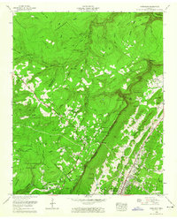 1958 Fairmount1959 Print · USGSThe mountain communities above Chattanooga were expanding in the late fifties as residential life met the steep terrain of the Cumberland Escarpment. Genealogists can trace early landmarks like Hall Cem, Schuylkill Chapel, and the Lone Oak School.2 unique versions available
 - 1958 Map of East Ridge, 1959 Print
 1958 East Ridge1959 Print · USGSCrossing the Tennessee and Georgia border in the late fifties, this area shows the development around East Ridge and the National Military Park. Genealogists can trace family landmarks like Newman Springs Cem, Shiloh Ch, and Swanson Mill.2 unique versions available
 - 1958 Map of East Chattanooga, 1959 Print
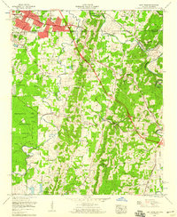
 1958 East Chattanooga1959 Print · USGSEast Chattanooga and its surrounding ridges were undergoing a period of rapid suburban and industrial expansion in the late fifties. Genealogists and historians can trace family burial sites like Varnell Cem or locate early institutions such as Bonny Oaks Sch and the William L Bork Memorial Hospital.2 unique versions available
 - 1958 Map of Fort Oglethorpe, 1959 Print
 1958 Fort Oglethorpe1959 Print · USGSCrossing the state line in the late fifties, this survey captures the convergence of Civil War memory and mid-century suburbanization. Trace historical sites within the National Military Park or locate family roots near Shields Crossroads and Blowing Spring.2 unique versions available
 - 1958 Map of Rome, 1966 Print
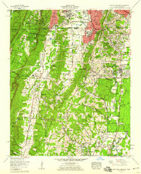
 1958 Rome1966 Print · USGSNorthwest Georgia and neighboring Tennessee and Alabama are captured here in the late fifties, showcasing a landscape of high ridges and river valleys. Researchers can trace historic rail lines like the Seaboard Air Line RR and explore the bounds of Cloudland Canyon State Park or Fort Oglethorpe.3 unique versions available
 - 1959 Map of Chattanooga
 1959 Chattanooga1959 Print · USGSSoutheast Tennessee is shown here during a decade of industrial growth and hydroelectric development. Trace the regional rail networks of the Southern Ry and find landmark sites like Lookout Mountain, Fall Creek Falls State Park, and Chattanooga.
End of results
Showing maps 1-11 of 11
Top cities of Hamilton County
- Chattanooga historical maps
- East Ridge historical maps
- Soddy-Daisy historical maps
- Collegedale historical maps
- Signal Mountain historical maps
- Walden historical maps
See more
Frequently asked questions
- What are the different types of historical maps available for Hamilton County?
- What is the oldest map of Hamilton County?
- Where can I purchase historical maps of Hamilton County for my home or office?
- Where can I download high-res historical maps of Hamilton County?
- Are there historical topographic maps available for Hamilton County?
- Is there historical aerial imagery available for Hamilton County?
- Where are historical maps of Hamilton County sourced from?