1930s Maps of Brewster County, Texas
Explore 7 historic maps of Brewster County from the 1930s. These maps offer a rare glimpse into what life looked like during the 1930s — showing old roads, neighborhoods, homes, and landmarks that have changed or disappeared over time.
Whether you're researching your family's past, planning a metal detecting trip, or studying how Brewster County's landscape evolved across the 1930s, these high-resolution maps are a powerful tool for exploring the history of this region.
- Focus on a specific era: All maps on this page are from the 1930s, giving you a focused view of this time period.
- See what’s changed: Compare century-old streets, trails, and buildings to today's modern landscape using overlays and satellite layers.
- Research with precision: Use these maps for genealogy, historical research, land use analysis, or educational projects.
- View, download, or print: Maps are fully viewable online in high resolution, and can be downloaded or printed for your own records.
Start exploring Brewster County's history through authentic maps from the 1930s. This is your window into the past.
Brewster County, TX maps
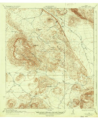
(7)- 1930 Map of Jordan Gap
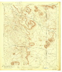 1930 Jordan Gap1930 Print · USGSPresidio and Brewster Counties are captured in the interwar years, showing a landscape of high mesas and desert passes. Genealogists and historians can trace old trails To Marfa and locate family-named landmarks like McKinney Mtn and McTurney Pk.3 unique versions available
 - 1930 Map of Stillwell Creek
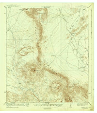
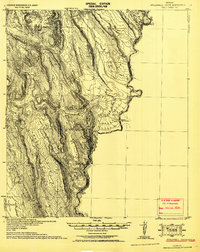 1930 Stillwell Creek1930 Print · USGSThe Texas borderlands along the Rio Grande are documented here in the early thirties as the region remained a territory of remote ranches and desert industry. Trace local landmarks like the Walkers Ranch, the Roberts (Wax Plant), and the deep Maravillas Canyon.
 - 1931 Map of Lajitas
 1931 Lajitas1931 Print · USGSThe Big Bend borderlands come into focus in the early 1930s, showing the isolated ranches and rugged volcanic landscape along the Rio Grande. Genealogists and historians can trace remote outposts like Madrid Ranch, the distinctive El Solitario dome, and the old Telephone Trail.
 - 1931 Map of Hood Spring
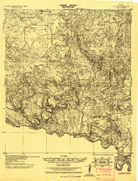
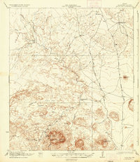
 1931 Hood Spring1931 Print · USGSBrewster County ranching and desert travel come into focus in this early twentieth-century survey of the West Texas high desert. Researchers can locate remote water sources like Kincaid Spring and trace the original path of the Marathon and Boquillas Road.
 - 1937 Map of Nine Point Mesa
 1937 Nine Point Mesa1937 Print · USGSBrewster County ranching life is frozen in time in this survey from the years following the first world war. Genealogists and historians can trace family landholdings at Johnson Ranch and Buttrill Ranch or follow the path of the Stormy Lease Trail.2 unique versions available
 - 1937 Map of Agua Fria
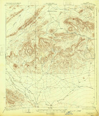
 1937 Agua Fria1937 Print · USGSBrewster County's high desert was a landscape of remote ranching outposts and vital wagon trails during the early twentieth century. Researchers can trace the path of the Old Stage Stand and locate family landmarks like Adams Ranch or the well-hidden Hale Cabin.
 - 1938 Map of Santiago Peak
 1938 Santiago Peak1938 Print · USGSBrewster County ranching life during the early twentieth century is captured here in the shadow of the Santiago Mountains. Researchers can locate legacy family holdings like the Schuler Ranch and Fords Ranch or trace the drainage of Maravillas Creek.2 unique versions available
End of results
Showing maps 1-7 of 7
Top cities of Brewster County
Frequently asked questions
- What are the different types of historical maps available for Brewster County?
- What is the oldest map of Brewster County?
- Where can I purchase historical maps of Brewster County for my home or office?
- Where can I download high-res historical maps of Brewster County?
- Are there historical topographic maps available for Brewster County?
- Is there historical aerial imagery available for Brewster County?
- Where are historical maps of Brewster County sourced from?