1980s Maps of Brewster County, Texas
Explore 78 historic maps of Brewster County from the 1980s. These maps offer a rare glimpse into what life looked like during the 1980s — showing old roads, neighborhoods, homes, and landmarks that have changed or disappeared over time.
Whether you're researching your family's past, planning a metal detecting trip, or studying how Brewster County's landscape evolved across the 1980s, these high-resolution maps are a powerful tool for exploring the history of this region.
- Focus on a specific era: All maps on this page are from the 1980s, giving you a focused view of this time period.
- See what’s changed: Compare century-old streets, trails, and buildings to today's modern landscape using overlays and satellite layers.
- Research with precision: Use these maps for genealogy, historical research, land use analysis, or educational projects.
- View, download, or print: Maps are fully viewable online in high resolution, and can be downloaded or printed for your own records.
Start exploring Brewster County's history through authentic maps from the 1980s. This is your window into the past.
Brewster County, TX maps
(78)- 1980 Map of Henderson Mesa
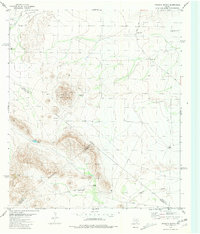
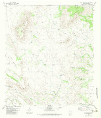
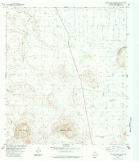
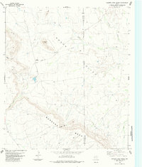
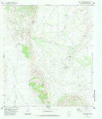
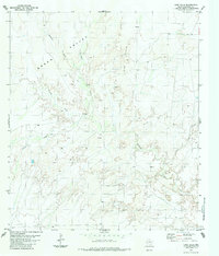
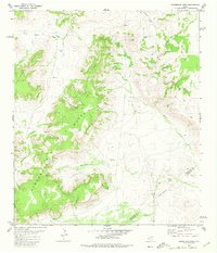 1980 Henderson Mesa1980 Print · USGSThe West Texas high desert and the county line between Jeff Davis and Brewster come into focus in the early eighties. Researchers can trace remote routes like the Pack Trail and find family-named landmarks including Polks Peak and Henderson Mesa.
 - 1980 Map of Cave Mesa
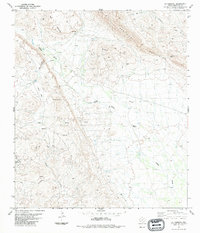
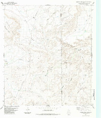
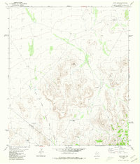 1980 Cave Mesa1980 Print · USGSThe West Texas high desert at the start of the 1980s was a landscape defined by isolated ranching infrastructure and striking topography. Researchers can trace the rugged county line and find essential water features like Rooney Tank, Burnt House Creek, and Cave Mesa.
 - 1980 Map of Hovey
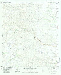
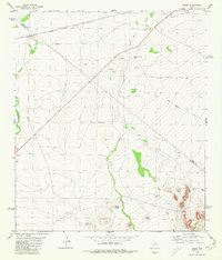 1980 Hovey1980 Print · USGSThe Trans-Pecos ranching country of the early 1980s is defined here by the transit corridor of the Atchison Topeka and Santa Fe. Local historians can locate remote outposts like Burnt House Creek Ranch, the high ground of Robbers Roost, and the tracks at Hovey.
 - 1980 Map of Hovey SW, 1981 Print
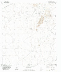
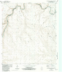
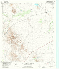 1980 Hovey SW1981 Print · USGSBrewster and Pecos counties in the early 1980s reveal a landscape of vast ranchlands and vital rail lines. Genealogists and historians can trace the Atchison Topeka and Santa Fe tracks and find remote landmarks like Humble Well and U-Bar Tank.
 - 1980 Map of Leoncita Ranch, 1981 Print
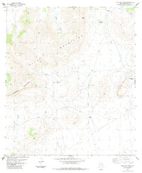
 1980 Leoncita Ranch1981 Print · USGSRanching life in the Trans-Pecos during the late seventies is centered on the water-scarce terrain where Pecos, Brewster, and Jeff Davis counties meet. Researchers can trace land use at Leoncita Ranch or locate landmarks like Benson Mountain and Waldo Windmill.
 - 1980 Map of Last Chance Mesa, 1981 Print
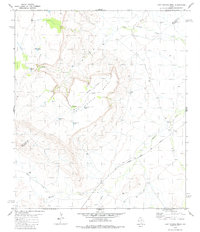 1980 Last Chance Mesa1981 Print · USGSThe border of Brewster and Jeff Davis counties in the early 1980s reveals a ranching landscape centered on Last Chance Mesa. Genealogists and historians can trace the Atchison Topeka and Santa Fe rail line and numerous named water sites like Herradura Tank and Musquiz Creek.
 - 1983 Map of Mount Ord
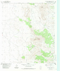
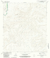
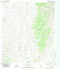 1983 Mount Ord1983 Print · USGSThe Del Norte Mountains of Brewster County are shown here in the early 1980s, revealing a remote landscape defined by high peaks and hidden springs. Researchers can locate unique landmarks like Opal Mine Hill, Eagle Peak, and Nine Troughs Spring.
 - 1983 Map of Cactus Flat
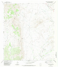
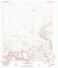 1983 Cactus Flat1983 Print · USGSPresidio and Brewster Counties are captured in the early 1980s, showing a remote ranching landscape of high mesas and desert gaps. Researchers can locate established homesteads like Crosson Ranch and trace paths through Bootlegger Canyon or Rustlers Gap.
 - 1983 Map of Goat Mountain
 1983 Goat Mountain1983 Print · USGSBrewster County's ranching frontier remains largely unchanged in the early eighties, centered around isolated outposts and seasonal water. Trace the locations of Adobe Ranch, Hess Windmill, and numerous desert water sources like Indian Pass Spring.
 - 1983 Map of Tinaja NE
 1983 Tinaja NE1983 Print · USGSThe high-desert ranchlands of West Texas are captured here in the early 1980s, where the county line divides remote pastoral outposts. Genealogists and historians can trace family operations like Loma Vista Ranch or the One O One Ranch near the Atchison Topeka and Santa Fe rail line.
 - 1983 Map of Cathedral Mountain
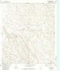
 1983 Cathedral Mountain1983 Print · USGSBrewster County in the early eighties was a high-desert landscape defined by vast ranchlands and prominent peaks. Researchers can trace land use through the placement of Terry Well and Quarries, or locate a solitary Grave near the headwaters of Calamity Creek.
 - 1983 Map of Elephant Mountain
 1983 Elephant Mountain1983 Print · USGSIn the Trans-Pecos during the early eighties, this Brewster County landscape is defined by massive desert uplands and isolated ranching outposts. Researchers can trace remote water sources like Sheep Creek and Springs or locate landmarks such as Roadside Park and Nevill Mesa.
 - 1983 Map of Packsaddle Mountain, 1984 Print
 1983 Packsaddle Mountain1984 Print · USGSBrewster County's high desert reaches are captured here during the 1970s and 1980s, centered on the heights of Packsaddle Mountain. Researchers can trace the desert water system through Cheosa Waterhole or locate the solitary Mine near the southern peaks.2 unique versions available
 - 1983 Map of Butterbowl, 1984 Print
 1983 Butterbowl1984 Print · USGSBrewster County's high desert landscape is documented here in the early 1980s, showcasing the remote terrain of the Trans-Pecos. Researchers can trace land use patterns through features like the Upper Landing Strips, North Windmill, and Rotten Canyon Spring.
 - 1983 Map of San Francisco Shutups, 1984 Print
 1983 San Francisco Shutups1984 Print · USGSBrewster County ranching and geology are captured in the early 1980s, showcasing the isolated landscapes of the Trans-Pecos. Researchers can trace the path of San Francisco Creek through the San Francisco Shutups and locate the remote Slaughter Ranch and its associated Landing Strips.
 - 1983 Map of Panther Gulch East, 1984 Print
 1983 Panther Gulch East1984 Print · USGSThe borderlands of the Big Bend region in the early eighties show a stark landscape defined by the winding Rio Grande Rio Bravo. Researchers can trace the international boundary near Mesa Juan Botas, identifying remote Landing Strips and the peaks of the Sierra La Chulita.
 - 1983 Map of Bandera Mesa North, 1984 Print
 1983 Bandera Mesa North1984 Print · USGSThe high desert of Presidio and Brewster counties comes into focus in the early eighties, revealing a landscape of mesas and ranching outposts. Trace the cattle-country geography of Rancho del Martillo, the heights of Needle Peak, and the passage at Smugglers Gap.
 - 1983 Map of Bandera Mesa South, 1984 Print
 1983 Bandera Mesa South1984 Print · USGSPresidio and Brewster Counties are captured in the late twentieth century as a landscape of isolated ranching and high mesas. Researchers can trace the remote operations of Bennett Ranch and Los Alamos Ranch or locate the Shearing Pens Windmill.
 - 1983 Map of Las Vegas De Los Ladrones SW, 1984 Print
 1983 Las Vegas De Los Ladrones SW1984 Print · USGSThe Chihuahuan Desert landscape of the early eighties is captured here along the Texas-Mexico border in Brewster County. Researchers can trace the international boundary following the Rio Grande Rio Bravo past landmarks like Cerro El Sombrero and Las Mulas.
 - 1983 Map of Dugout Mountain, 1984 Print
 1983 Dugout Mountain1984 Print · USGSThe high desert of Brewster County is captured here in the early eighties, showcasing the rail-dependent settlement of Lenox. Researchers can trace the legacy of West Texas ranching through isolated water points like Twin China Well, Billy Trap Windmill, and Emilio Spring.
 - 1983 Map of Rock House Gap, 1984 Print
 1983 Rock House Gap1984 Print · USGSBrewster County's high desert is captured here in the early eighties, revealing the vital water infrastructure that supported remote ranching operations. Researchers can trace land use through features like the Twin China Windmill, Rock House Gap, and Shaler Spring.
 - 1983 Map of Gilliland Peak, 1984 Print
 1983 Gilliland Peak1984 Print · USGSThe Trans-Pecos ranchlands of the early eighties are mapped here in detail, showing a sparse landscape dominated by the high ridges of the Glass Mountains. Researchers can trace old family footprints at Iron Mountain Ranch or locate isolated markers like the Cem and a lone Grave.
 - 1983 Map of Black Gap, 1984 Print
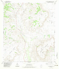
 1983 Black Gap1984 Print · USGSBrewster County in the early eighties was a landscape of high peaks and protected lands centered around the Black Gap Wildlife Management Area. Researchers can trace the remote roads and outposts of the Trans-Pecos, from the Headquarters at Black Gap to the winding depths of Dog Canyon.
 - 1983 Map of Simpson Springs Mountain, 1984 Print
 1983 Simpson Springs Mountain1984 Print · USGSBrewster County ranching and rugged desert peaks are captured here in the early eighties. Researchers can trace historic water sources and property markers like Combs Ranch, Sunshine Springs, and the LBJ Windmill across this high-altitude landscape.
 - 1983 Map of Long Hills, 1984 Print
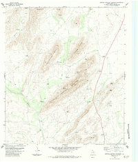
 1983 Long Hills1984 Print · USGSBrewster County's high desert landscape comes into focus during the early eighties, showing a terrain shaped by winding drainages and isolated outposts. Researchers can trace the path of Terlingua Creek past Burnt House Camp or locate old mining prospects tucked into the Long Hills.
Showing maps 1-25 of 78
Top cities of Brewster County
Frequently asked questions
- What are the different types of historical maps available for Brewster County?
- What is the oldest map of Brewster County?
- Where can I purchase historical maps of Brewster County for my home or office?
- Where can I download high-res historical maps of Brewster County?
- Are there historical topographic maps available for Brewster County?
- Is there historical aerial imagery available for Brewster County?
- Where are historical maps of Brewster County sourced from?