1890s Maps of Brewster County, Texas
Explore 3 historic maps of Brewster County from the 1890s. These maps offer a rare glimpse into what life looked like during the 1890s — showing old roads, neighborhoods, homes, and landmarks that have changed or disappeared over time.
Whether you're researching your family's past, planning a metal detecting trip, or studying how Brewster County's landscape evolved across the 1890s, these high-resolution maps are a powerful tool for exploring the history of this region.
- Focus on a specific era: All maps on this page are from the 1890s, giving you a focused view of this time period.
- See what’s changed: Compare century-old streets, trails, and buildings to today's modern landscape using overlays and satellite layers.
- Research with precision: Use these maps for genealogy, historical research, land use analysis, or educational projects.
- View, download, or print: Maps are fully viewable online in high resolution, and can be downloaded or printed for your own records.
Start exploring Brewster County's history through authentic maps from the 1890s. This is your window into the past.
Brewster County, TX maps
(3)- 1894 Map of Fort Davis, 1961 Print
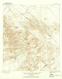 1894 Fort Davis1961 Print · USGSWest Texas in the late nineteenth century was a frontier of family ranching and vital springs. Genealogists and historians can trace the early locations of Fort Davis and numerous homesteads like Wards Ranch, Mahle's Ranch, and Huelster.
 - 1895 Map of Alpine
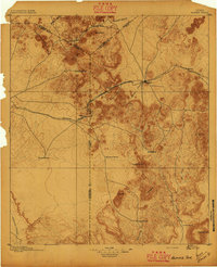 1895 Alpine1895 Print · USGSWest Texas ranching and rail life come into focus in the 1890s, centered on the growing hub of Alpine. Family historians can trace early landholdings like Greenlee Ranch and Neville Ranch alongside the vital Southern Pacific line.6 unique versions available
 - 1897 Map of Fort Davis
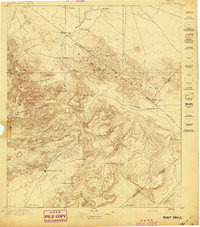 1897 Fort Davis1897 Print · USGSWest Texas ranching life and mountain topography are preserved in this 1890s survey centered on the frontier outpost of Fort Davis. Researchers can trace early family landholdings and essential water sites like Wards Ranch, Toyahvale, and Phantom Lake.3 unique versions available
End of results
Showing maps 1-3 of 3
Top cities of Brewster County
Frequently asked questions
- What are the different types of historical maps available for Brewster County?
- What is the oldest map of Brewster County?
- Where can I purchase historical maps of Brewster County for my home or office?
- Where can I download high-res historical maps of Brewster County?
- Are there historical topographic maps available for Brewster County?
- Is there historical aerial imagery available for Brewster County?
- Where are historical maps of Brewster County sourced from?