1930s Maps of Cherokee County, Texas
Explore 3 historic maps of Cherokee County from the 1930s. These maps offer a rare glimpse into what life looked like during the 1930s — showing old roads, neighborhoods, homes, and landmarks that have changed or disappeared over time.
Whether you're researching your family's past, planning a metal detecting trip, or studying how Cherokee County's landscape evolved across the 1930s, these high-resolution maps are a powerful tool for exploring the history of this region.
- Focus on a specific era: All maps on this page are from the 1930s, giving you a focused view of this time period.
- See what’s changed: Compare century-old streets, trails, and buildings to today's modern landscape using overlays and satellite layers.
- Research with precision: Use these maps for genealogy, historical research, land use analysis, or educational projects.
- View, download, or print: Maps are fully viewable online in high resolution, and can be downloaded or printed for your own records.
Start exploring Cherokee County's history through authentic maps from the 1930s. This is your window into the past.
Cherokee County, TX maps
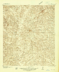
(3)- 1935 Map of Henderson
 1935 Henderson1935 Print · USGSRusk County in the mid-1930s is a landscape defined by the East Texas oil boom and its sprawling rural communities. Researchers can trace early family sites like Old London Cemetery and Duncan Cemetery or locate industrial landmarks like the Lisbon Gasoline Company Plant.
 - 1937 Map of Troupe
 1937 Troupe1937 Print · USGSEast Texas oil and rail culture are on full display in the 1930s as the Missouri Pacific railroad connects rural communities. Local historians can trace the foundations of the regional economy through sites like the Sun Oil Camp, St Clair City, and Henry's Chapel.
 - 1939 Map of Henderson
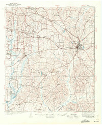 1939 Henderson1939 Print · USGSRusk County at the peak of the 1930s oil boom reveals a landscape of rapidly growing settlements and dense rural infrastructure. Researchers can trace the footprints of Joinerville, Old London, and Gaston School alongside the Missouri Pacific rail line.
End of results
Showing maps 1-3 of 3
Top cities of Cherokee County
- Jacksonville historical maps
- Rusk historical maps
- Alto historical maps
- New Summerfield historical maps
- Wells historical maps
- Gallatin historical maps
See more
Frequently asked questions
- What are the different types of historical maps available for Cherokee County?
- What is the oldest map of Cherokee County?
- Where can I purchase historical maps of Cherokee County for my home or office?
- Where can I download high-res historical maps of Cherokee County?
- Are there historical topographic maps available for Cherokee County?
- Is there historical aerial imagery available for Cherokee County?
- Where are historical maps of Cherokee County sourced from?