1970s Maps of Cherokee County, Texas
Explore 20 historic maps of Cherokee County from the 1970s. These maps offer a rare glimpse into what life looked like during the 1970s — showing old roads, neighborhoods, homes, and landmarks that have changed or disappeared over time.
Whether you're researching your family's past, planning a metal detecting trip, or studying how Cherokee County's landscape evolved across the 1970s, these high-resolution maps are a powerful tool for exploring the history of this region.
- Focus on a specific era: All maps on this page are from the 1970s, giving you a focused view of this time period.
- See what’s changed: Compare century-old streets, trails, and buildings to today's modern landscape using overlays and satellite layers.
- Research with precision: Use these maps for genealogy, historical research, land use analysis, or educational projects.
- View, download, or print: Maps are fully viewable online in high resolution, and can be downloaded or printed for your own records.
Start exploring Cherokee County's history through authentic maps from the 1970s. This is your window into the past.
Cherokee County, TX maps
(20)- 1973 Map of New Summerfield, 1976 Print
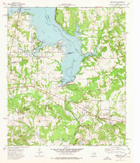
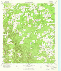
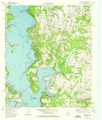
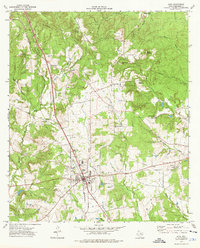
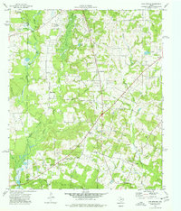
 1973 New Summerfield1976 Print · USGSCherokee County in the early seventies reveals a landscape of timbered hills and quiet railroad sidings. Genealogists can trace family connections at Union Hill Cem and Walkers Chapel Cem or locate the historic rail junctions at Ponta and Stryker Creek Junction.
 - 1973 Map of Berryville, 1976 Print
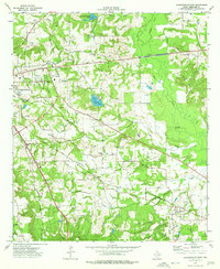
 1973 Berryville1976 Print · USGSLake Palestine and the Neches River valley define this East Texas landscape in the early seventies as new shorelines met established rail towns. Genealogists can trace family names through Kickapoo Cem, Wafford Cem, and the Kickapoo Battlefield Monument.2 unique versions available
 - 1973 Map of Jacksonville East, 1976 Print
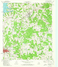
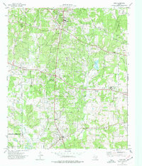
 1973 Jacksonville East1976 Print · USGSJacksonville and its rural surroundings are captured in the early 1970s as a thriving rail and agricultural center. Researchers can trace family history at Piney Grove Cem or locate old community hubs like Afton Grove and Gallatin.2 unique versions available
 - 1973 Map of Troup West, 1976 Print
 1973 Troup West1976 Print · USGSSettlements in eastern Smith County flourished along the rail lines and reservoir shores during the early 1970s. Genealogists and local historians can locate several family landmarks and community centers, including Memorial Cem, Walnut Grove Ch, and the Troup townsite.2 unique versions available
 - 1973 Map of Troup East, 1976 Print
 1973 Troup East1976 Print · USGSEast Texas in the early seventies was a landscape where petroleum production met quiet rural life. Genealogists and historians can trace the family landmarks of Sinclair City and Arp alongside numerous sites like Shiloh Cem and Mason Ch.
 - 1973 Map of Atoy, 1976 Print
 1973 Atoy1976 Print · USGSEast Texas rural life in the 1970s centers on timbered hills and quiet settlements like Atoy and Circle. Genealogists and historians can trace family locations through Walker Cem and Cornelius Cem, or locate landmarks like Jim Hogg State Park.
 - 1973 Map of Tecula, 1976 Print
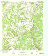
 1973 Tecula1976 Print · USGSCherokee County in the early 1970s was a landscape of small creek-side settlements and emerging energy infrastructure. Researchers can locate family landmarks such as Taylors Chapel, Tecula Cem, and the path of the Missouri Pacific railroad.
 - 1973 Map of Mount Selman, 1976 Print
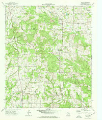
 1973 Mount Selman1976 Print · USGSCherokee County in the early 1970s reveals a landscape of deep-rooted settlements and emerging energy production. Genealogists can trace family sites at Larissa Cem and Killough Cem, while historians can follow the St Louis Southwestern rail line.
 - 1973 Map of New Salem, 1976 Print
 1973 New Salem1976 Print · USGSThe border of Rusk and Cherokee counties in the early 1970s shows a landscape of East Texas timber and industry. Trace the legacy of rural communities at New Salem and Anadarko, alongside historic sites like Cool Springs Cem and the Southern Pacific railroad.
 - 1973 Map of Saline Bay, 1976 Print
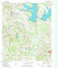
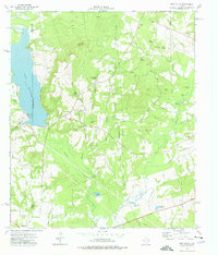
 1973 Saline Bay1976 Print · USGSThe East Texas lakefront was rapidly evolving in the early seventies as Lake Palestine submerged the old Neches River valley. Researchers can trace the development of Coffee City or locate rural sites like Bethlehem Church and Loffin Cemetery.3 unique versions available
 - 1973 Map of Pryor Mountain, 1976 Print
 1973 Pryor Mountain1976 Print · USGSEast Texas in the early 1970s is seen here as a landscape of wooded ridges and small upland communities in Cherokee County. Genealogists and local historians can trace family locations near Bulah, the William Wise Oil Field, and Hudson Chapel.
 - 1973 Map of Reklaw, 1976 Print
 1973 Reklaw1976 Print · USGSThe rural tri-county borderlands of East Texas are captured here in the 1970s, as the Southern Pacific rail line linked small timber and farming outposts. Genealogists can locate family landmarks like Looney Cem and McKnight Ch, or trace the old paths near Dextra.
 - 1973 Map of Forest, 1976 Print
 1973 Forest1976 Print · USGSCherokee County in the early seventies centers on the rail-linked communities of Forest and Morrill as they border the deep river bottomlands. Researchers can trace old family sites at Arnold Cem and Thompson Cem or explore the river bends of the Neches River.
 - 1973 Map of Alto, 1976 Print
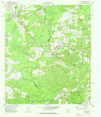
 1973 Alto1976 Print · USGSIn the early 1970s, the East Texas crossroads of Alto remained a vital rail and road center amid the wooded heights of Cherokee County. Genealogists can trace family footprints at Old Palestine Cem, Harrison Cem, and the community of Redlawn.
 - 1973 Map of Weches, 1977 Print
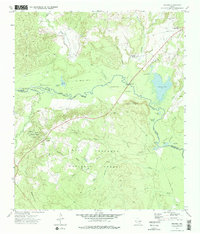 1973 Weches1977 Print · USGSEast Texas timberlands and river bottoms are captured here in the early seventies, spanning the border of Houston and Cherokee counties. Researchers can trace the path of the Old Railroad Grade or locate local landmarks like Weeping Mary and St Thomas Chapel.2 unique versions available
 - 1973 Map of Griffin, 1977 Print
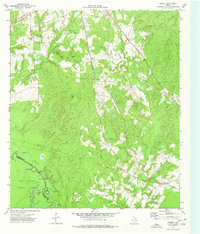
 1973 Griffin1977 Print · USGSCherokee County in the early 1970s remains a landscape of rural communities and winding creek branches. Researchers can trace family history through sites like Knoxville Cemetery, Henrys Chapel, and the small settlement of Blackjack.
 - 1973 Map of Price, 1977 Print
 1973 Price1977 Print · USGSRusk County entered the 1970s as a landscape defined by the machinery of the petroleum industry and old crossroads communities. Researchers can trace the legacy of the East Texas Oil Field alongside local landmarks like West Rusk High Sch, Old London, and the Black Jack Cem.
 - 1973 Map of Gum Springs, 1977 Print
 1973 Gum Springs1977 Print · USGSEast Texas petroleum production and rural life meet in the 1970s across this portion of Rusk and Cherokee Counties. Researchers can locate numerous family burial sites like Waggoner Cem and local centers including Good Springs and Macedonia Ch.
 - 1973 Map of Rusk, 1977 Print
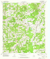
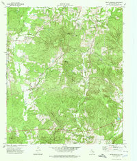
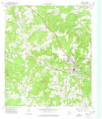 1973 Rusk1977 Print · USGSCherokee County in the early seventies centers on the intersection of the St Louis Southwestern and Texas State Railroad. Researchers can trace old family burial sites like Ford Cem and Weems Cem or explore the vast grounds of the Rusk State Hospital.
 - 1973 Map of Bullard, 1977 Print
 1973 Bullard1977 Print · USGSThe ST LOUIS SOUTHWESTERN rail line cuts through the heart of East Texas in the early seventies, connecting rural communities across Smith and Cherokee counties. Genealogists can trace family landmarks like Barron Cem, Rather Cem, and the community of Flint.
End of results
Showing maps 1-20 of 20
Top cities of Cherokee County
- Jacksonville historical maps
- Rusk historical maps
- Alto historical maps
- New Summerfield historical maps
- Wells historical maps
- Gallatin historical maps
See more
Frequently asked questions
- What are the different types of historical maps available for Cherokee County?
- What is the oldest map of Cherokee County?
- Where can I purchase historical maps of Cherokee County for my home or office?
- Where can I download high-res historical maps of Cherokee County?
- Are there historical topographic maps available for Cherokee County?
- Is there historical aerial imagery available for Cherokee County?
- Where are historical maps of Cherokee County sourced from?