Old Maps of Cherokee County, Texas for Academic Research
Study the evolution of Cherokee County with 218 high-resolution historic maps. Whether you're teaching, researching, or modeling changes in land use, these maps provide essential visual documentation of urban, environmental, and geographic change.
- Analyze long-term change: Track patterns in development, transportation, and natural features.
- Ideal for environmental or urban studies: Support academic projects with primary historical map data.
- Use in the classroom or lab: Educators and researchers rely on these maps to bring historical context to life.
These maps are a powerful tool for teaching, research, and visualizing how Cherokee County has changed over the decades.
Cherokee County, TX maps
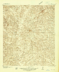
(218)- 1935 Map of Henderson
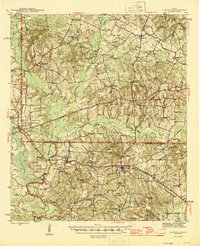
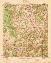
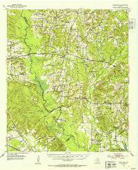
 1935 Henderson1935 Print · USGSRusk County in the mid-1930s is a landscape defined by the East Texas oil boom and its sprawling rural communities. Researchers can trace early family sites like Old London Cemetery and Duncan Cemetery or locate industrial landmarks like the Lisbon Gasoline Company Plant.
 - 1937 Map of Troupe
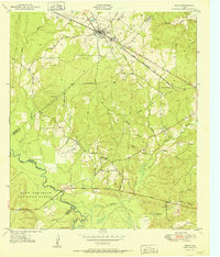
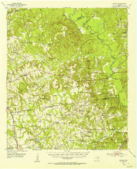
 1937 Troupe1937 Print · USGSEast Texas oil and rail culture are on full display in the 1930s as the Missouri Pacific railroad connects rural communities. Local historians can trace the foundations of the regional economy through sites like the Sun Oil Camp, St Clair City, and Henry's Chapel.
 - 1939 Map of Henderson
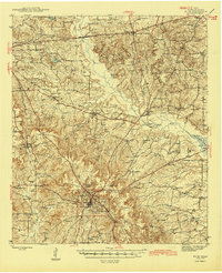
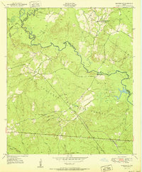
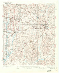 1939 Henderson1939 Print · USGSRusk County at the peak of the 1930s oil boom reveals a landscape of rapidly growing settlements and dense rural infrastructure. Researchers can trace the footprints of Joinerville, Old London, and Gaston School alongside the Missouri Pacific rail line.
 - 1943 Map of Troup
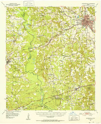
 1943 Troup1943 Print · USGSEast Texas agriculture and rail towns thrive in the late 1930s along the Smith and Cherokee County line. Family historians can trace rural roots through numerous landmarks like Tecula Cem, Walnut Grove Ch, and Enterprise Sch.3 unique versions available
 - 1943 Map of Cushing, 1955 Print
 1943 Cushing1955 Print · USGSCushing and the rural crossroads of East Texas are seen here during the mid-forties as the railroad still anchored the local economy. Researchers can locate vanished rural landmarks like Freekeytown or trace the Southern Pacific line through Sacul and Reklaw.
 - 1943 Map of Rusk, 1961 Print
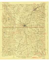
 1943 Rusk1961 Print · USGSEast Texas in the early 1940s reveals a landscape of rural communities anchored by local schools and the intersection of major railroads. Trace family roots through specific landmarks like Iron Hill Sch, Earl Chapel, and the vast grounds of the State Hospital.
 - 1945 Map of Cushing
 1945 Cushing1945 Print · USGSEast Texas farm and timber country thrives during the mid-forties along the borders of Nacogdoches, Rusk, and Cherokee counties. Genealogists can trace family roots through numerous rural landmarks like Mays Cem, Happy Valley Ch, and Glenwood Sch.
 - 1945 Map of Rusk
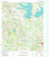
 1945 Rusk1945 Print · USGSCherokee County at the close of World War II shows a landscape deeply connected by the Southern Pacific and Missouri Pacific railroads. Researchers can trace rural life through dozens of local landmarks like Henry Cem, Bagley Chapel, and the community at Dialville.2 unique versions available
 - 1946 Map of Alto
 1946 Alto1946 Print · USGSEast Texas at the end of World War II reveals a landscape deeply connected to its frontier origins, anchored by Alto and the Neches River. Genealogists and historians can trace local landmarks like the Bowles Monument, Central High Sch, and the Site of Ft Lacy along the historic El Camino Real.2 unique versions available
 - 1946 Map of Bullard, 1960 Print
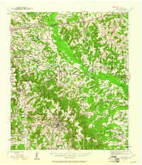
 1946 Bullard1960 Print · USGSEast Texas rail and river life converge in the 1940s as the St Louis Southwestern tracks link rural farming hubs. Trace local family history through numerous landmarks like Larissa Cem, the Kickapoo Monument, and Mount Selman.2 unique versions available
 - 1948 Map of Bullard
 1948 Bullard1948 Print · USGSNortheastern Cherokee and southern Smith counties are captured here in the late forties, showcasing a network of rural schools and rail-fed towns. Genealogists can trace family sites at Larissa Cem, Mount Comfort Ch, and the high ground of Kickapoo Mtn.
 - 1950 Map of Kennard NE, 1973 Print
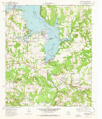
 1950 Kennard NE1973 Print · USGSEast Texas timber country comes into focus in this mid-century survey of the Neches River valley at the edge of the Crockett National Forest. Genealogists and historians can trace the foundations of rural life through the Shooks Bluff Cem, Sweet Union Ch, and the winding paths of an Old Railroad Grade.2 unique versions available
 - 1951 Map of Wells
 1951 Wells1951 Print · USGSCherokee County at mid-century shows a landscape shaped by timber and rail as the Piney Woods met the Neches River. Researchers can locate family landmarks like Simpson Cem, the rural center of Redtown, and the St Louis Southwestern Railroad line.3 unique versions available
 - 1951 Map of Kennard NE
 1951 Kennard NE1951 Print · USGSEast Texas timber country and forest life are captured here in the early fifties as logging operations shaped the Houston County landscape. Genealogists and historians can trace the Old Railroad Grade, locate the Shooks Bluff Cem, and find rural landmarks like Plain Ch and Wells Sch.
 - 1951 Map of Jacksonville, 1952 Print
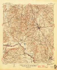
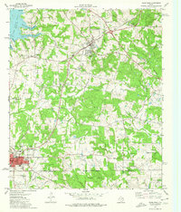
 1951 Jacksonville1952 Print · USGSCherokee County thrived as a railroad and collegiate center at the midpoint of the century. Genealogists and historians can trace family roots through numerous rural landmarks like West Shady Grove Cem, Mewshaw, and the Maydelle community.2 unique versions available
 - 1952 Map of Douglass, 1953 Print
 1952 Douglass1953 Print · USGSNacogdoches County in the early fifties shows a landscape of deep-rooted rural communities and changing industrial footprints. Researchers can trace the path of the Old San Antonio Road and locate family landmarks like Blackjack Cemetery and Grange Hall School.2 unique versions available
 - 1952 Map of Slocum, 1953 Print
 1952 Slocum1953 Print · USGSEast Texas timber and creek country comes alive in the early fifties, showing the rural landscapes of Anderson and Houston counties. Genealogists can locate family sites and pioneer burials at Union Hope Sch & Cem, Livelyville Ch (Cem), and Mound City.2 unique versions available
 - 1953 Map of Palestine, 1964 Print
 1953 Palestine1964 Print · USGSEast Texas was defined by its deep pine forests and burgeoning energy sector in the mid-1950s. Genealogists and historians can trace the rail-and-river economy through settlements like Tennessee Colony and Pollok or explore the early footprints of the Cayuga Oil Field and Davy Crockett National Forest.2 unique versions available
 - 1956 Map of Tyler
 1956 Tyler1956 Print · USGSEast Texas was a powerhouse of oil production and rail transport during the mid-fifties, centered on the sprawling East Texas Oil Field. Researchers can trace the heritage of industrial hubs like Kilgore, military sites such as the Longhorn Ordnance Works, and many rural landmarks like Mount Enterprise.5 unique versions available
 - 1957 Map of Palestine
 1957 Palestine1957 Print · USGSEast Texas in the mid-fifties reveals a landscape of deep pine forests and winding river valleys before the era of massive reservoir construction. Researchers can trace the legacy of the timber and rail industries through labels for the Missouri Pacific RR, Davy Crockett National Forest, and Nacogdoches.
 - 1973 Map of New Summerfield, 1976 Print
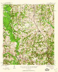
 1973 New Summerfield1976 Print · USGSCherokee County in the early seventies reveals a landscape of timbered hills and quiet railroad sidings. Genealogists can trace family connections at Union Hill Cem and Walkers Chapel Cem or locate the historic rail junctions at Ponta and Stryker Creek Junction.
 - 1973 Map of Berryville, 1976 Print
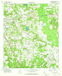
 1973 Berryville1976 Print · USGSLake Palestine and the Neches River valley define this East Texas landscape in the early seventies as new shorelines met established rail towns. Genealogists can trace family names through Kickapoo Cem, Wafford Cem, and the Kickapoo Battlefield Monument.2 unique versions available
 - 1973 Map of Jacksonville East, 1976 Print
 1973 Jacksonville East1976 Print · USGSJacksonville and its rural surroundings are captured in the early 1970s as a thriving rail and agricultural center. Researchers can trace family history at Piney Grove Cem or locate old community hubs like Afton Grove and Gallatin.2 unique versions available
 - 1973 Map of Troup West, 1976 Print
 1973 Troup West1976 Print · USGSSettlements in eastern Smith County flourished along the rail lines and reservoir shores during the early 1970s. Genealogists and local historians can locate several family landmarks and community centers, including Memorial Cem, Walnut Grove Ch, and the Troup townsite.2 unique versions available
 - 1973 Map of Troup East, 1976 Print
 1973 Troup East1976 Print · USGSEast Texas in the early seventies was a landscape where petroleum production met quiet rural life. Genealogists and historians can trace the family landmarks of Sinclair City and Arp alongside numerous sites like Shiloh Cem and Mason Ch.
Showing maps 1-25 of 218
Top cities of Cherokee County
- Jacksonville historical maps
- Rusk historical maps
- Alto historical maps
- New Summerfield historical maps
- Wells historical maps
- Gallatin historical maps
See more
Frequently asked questions
- What are the different types of historical maps available for Cherokee County?
- What is the oldest map of Cherokee County?
- Where can I purchase historical maps of Cherokee County for my home or office?
- Where can I download high-res historical maps of Cherokee County?
- Are there historical topographic maps available for Cherokee County?
- Is there historical aerial imagery available for Cherokee County?
- Where are historical maps of Cherokee County sourced from?