1920s Maps of Baytown, Texas
Explore 2 historic maps of Baytown from the 1920s. These maps offer a rare glimpse into what life looked like during the 1920s — showing old roads, neighborhoods, homes, and landmarks that have changed or disappeared over time.
Whether you're researching your family's past, planning a metal detecting trip, or studying how Baytown's landscape evolved across the 1920s, these high-resolution maps are a powerful tool for exploring the history of this region.
- Focus on a specific era: All maps on this page are from the 1920s, giving you a focused view of this time period.
- See what’s changed: Compare century-old streets, trails, and buildings to today's modern landscape using overlays and satellite layers.
- Research with precision: Use these maps for genealogy, historical research, land use analysis, or educational projects.
- View, download, or print: Maps are fully viewable online in high resolution, and can be downloaded or printed for your own records.
Start exploring Baytown's history through authentic maps from the 1920s. This is your window into the past.
Baytown, TX maps
(2)- 1920 Map of La Porte
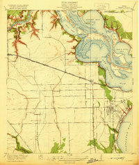 1920 La Porte1920 Print · USGSCoastal Harris County is documented here during a period of industrial growth along the Houston Ship Channel. Researchers can trace the early rail networks of the Galveston Harrisburg and San Antonio RR and locate community landmarks like Lomax School and Sylvan Beach.3 unique versions available
 - 1920 Map of Highlands
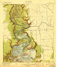 1920 Highlands1920 Print · USGSHarris County at the dawn of the oil age reveals a landscape of tidal bayous and historic river crossings. Genealogists can locate family landmarks like Tory Hill, early education sites like Lynchburg School, and the hallowed grounds of the San Jacinto Battlefield.4 unique versions available
End of results
Showing maps 1-2 of 2
Top cities near Baytown
- Houston historical maps
- Pasadena historical maps
- League City historical maps
- Channelview historical maps
- Texas City historical maps
- Friendswood historical maps
See more
Top neighborhoods of Baytown
- Pelly historical maps
- Wooster historical maps
- Brownwood historical maps
- Country Club Oaks historical maps
- Goose Creek Reserve historical maps
- Rolling Creek Estates historical maps
Frequently asked questions
- What are the different types of historical maps available for Baytown?
- What is the oldest map of Baytown?
- Where can I purchase historical maps of Baytown for my home or office?
- Where can I download high-res historical maps of Baytown?
- Are there historical topographic maps available for Baytown?
- Is there historical aerial imagery available for Baytown?
- Where are historical maps of Baytown sourced from?