1940s Maps of Baytown, Texas
Explore 5 historic maps of Baytown from the 1940s. These maps offer a rare glimpse into what life looked like during the 1940s — showing old roads, neighborhoods, homes, and landmarks that have changed or disappeared over time.
Whether you're researching your family's past, planning a metal detecting trip, or studying how Baytown's landscape evolved across the 1940s, these high-resolution maps are a powerful tool for exploring the history of this region.
- Focus on a specific era: All maps on this page are from the 1940s, giving you a focused view of this time period.
- See what’s changed: Compare century-old streets, trails, and buildings to today's modern landscape using overlays and satellite layers.
- Research with precision: Use these maps for genealogy, historical research, land use analysis, or educational projects.
- View, download, or print: Maps are fully viewable online in high resolution, and can be downloaded or printed for your own records.
Start exploring Baytown's history through authentic maps from the 1940s. This is your window into the past.
Baytown, TX maps
(5)- 1943 Map of West of Eagle
 1943 West of Eagle1943 Print · USGSCoastal Chambers County is captured here in the early 1940s along the western edge of Trinity Bay. Genealogists and local historians can trace family landmarks and early shoreline roads like Cedar Bayou Road and the Fisher Cem.
 - 1943 Map of Morgan Point
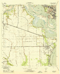
 1943 Morgan Point1943 Print · USGSThe coastal communities of Goose Creek, Baytown, and Pelly are shown in detail during the early 1940s as the regional maritime economy expanded. Researchers can trace the dual rail lines of the Southern Pacific and Missouri Pacific or locate local landmarks like the Hill of Rest Cem.
 - 1943 Map of Cedar Bayou, 1960 Print
 1943 Cedar Bayou1960 Print · USGSThe Gulf Coast oil and agriculture landscape comes alive in the 1940s as industry takes root near Mont Belvieu. Genealogists and historians can trace old family sites like Fisher Cem, Shiloh Ch, and the original Cedar Bayou Sch.
 - 1944 Map of La Porte
 1944 La Porte1944 Print · USGSCoastal Harris County is captured during the mid-forties, showing the vital maritime and rail corridors near the San Jacinto River. Genealogists and researchers can trace local landmarks like the La Porte Cem, the whistle-stop at Strang, and the recreational grounds of Sylvan Beach.
 - 1944 Map of Burnett Bay
 1944 Burnett Bay1944 Print · USGSCoastal Harris County during the mid-forties reveals a landscape of industrial expansion and historic river crossings. Genealogists and historians can trace family landmarks like the McGhee School and White Cem alongside the growing settlements of Highlands and Lynchburg.
End of results
Showing maps 1-5 of 5
Top cities near Baytown
- Houston historical maps
- Pasadena historical maps
- League City historical maps
- Channelview historical maps
- Texas City historical maps
- Friendswood historical maps
See more
Top neighborhoods of Baytown
- Pelly historical maps
- Wooster historical maps
- Brownwood historical maps
- Country Club Oaks historical maps
- Goose Creek Reserve historical maps
- Rolling Creek Estates historical maps
Frequently asked questions
- What are the different types of historical maps available for Baytown?
- What is the oldest map of Baytown?
- Where can I purchase historical maps of Baytown for my home or office?
- Where can I download high-res historical maps of Baytown?
- Are there historical topographic maps available for Baytown?
- Is there historical aerial imagery available for Baytown?
- Where are historical maps of Baytown sourced from?