1980s Maps of Baytown, Texas
Explore 5 historic maps of Baytown from the 1980s. These maps offer a rare glimpse into what life looked like during the 1980s — showing old roads, neighborhoods, homes, and landmarks that have changed or disappeared over time.
Whether you're researching your family's past, planning a metal detecting trip, or studying how Baytown's landscape evolved across the 1980s, these high-resolution maps are a powerful tool for exploring the history of this region.
- Focus on a specific era: All maps on this page are from the 1980s, giving you a focused view of this time period.
- See what’s changed: Compare century-old streets, trails, and buildings to today's modern landscape using overlays and satellite layers.
- Research with precision: Use these maps for genealogy, historical research, land use analysis, or educational projects.
- View, download, or print: Maps are fully viewable online in high resolution, and can be downloaded or printed for your own records.
Start exploring Baytown's history through authentic maps from the 1980s. This is your window into the past.
Baytown, TX maps
(5)- 1982 Map of Mont Belvieu
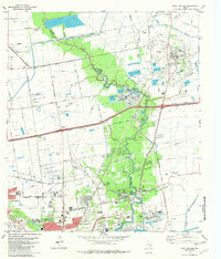 1982 Mont Belvieu1982 Print · USGSThe industrial and residential growth of the Texas Gulf Coast is captured here in the early eighties. Genealogists and historians can trace family sites like Busch Cem and Fisher Cem or locate the sprawling Oil and Gas Field and refinery works.
 - 1982 Map of Morgans Point
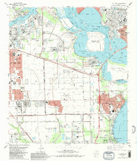
 1982 Morgans Point1982 Print · USGSBaytown and its surrounding coastal communities are shown here at the start of the 1980s, balancing industrial expansion with residential life. Genealogists and historians can trace neighborhood developments around Lee High Sch, the Hill of Rest Cem, and the specialized maritime docks at Barbours Cut.
 - 1982 Map of La Porte, 1983 Print
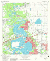
 1982 La Porte1983 Print · USGSThe industrial and maritime heart of the Texas coast comes into focus in the early eighties as the ship channel drives the local economy. Trace family history and regional growth at La Porte, San Jacinto State Park, and the Wooster Cem.
 - 1982 Map of Highlands, 1983 Print
 1982 Highlands1983 Print · USGSThe industrial and historical heart of the Texas coast comes into focus in the early eighties at the confluence of the San Jacinto River and Buffalo Bayou. Trace local heritage at the San Jacinto Monument, the De Zavala Cem, or the old streets of Lynchburg.2 unique versions available
 - 1983 Map of Anahuac
 1983 Anahuac1983 Print · USGSThe Upper Texas Coast and its energy-driven landscape are detailed here in the early eighties. Genealogists and historians can trace coastal settlements like Anahuac and Winnie alongside the storied Spindletop Oil Field and the Anahuac National Wildlife Refuge.2 unique versions available
End of results
Showing maps 1-5 of 5
Top cities near Baytown
- Houston historical maps
- Pasadena historical maps
- League City historical maps
- Channelview historical maps
- Texas City historical maps
- Friendswood historical maps
See more
Top neighborhoods of Baytown
- Pelly historical maps
- Wooster historical maps
- Brownwood historical maps
- Country Club Oaks historical maps
- Goose Creek Reserve historical maps
- Rolling Creek Estates historical maps
Frequently asked questions
- What are the different types of historical maps available for Baytown?
- What is the oldest map of Baytown?
- Where can I purchase historical maps of Baytown for my home or office?
- Where can I download high-res historical maps of Baytown?
- Are there historical topographic maps available for Baytown?
- Is there historical aerial imagery available for Baytown?
- Where are historical maps of Baytown sourced from?