1990s Maps of Baytown, Texas
Explore 9 historic maps of Baytown from the 1990s. These maps offer a rare glimpse into what life looked like during the 1990s — showing old roads, neighborhoods, homes, and landmarks that have changed or disappeared over time.
Whether you're researching your family's past, planning a metal detecting trip, or studying how Baytown's landscape evolved across the 1990s, these high-resolution maps are a powerful tool for exploring the history of this region.
- Focus on a specific era: All maps on this page are from the 1990s, giving you a focused view of this time period.
- See what’s changed: Compare century-old streets, trails, and buildings to today's modern landscape using overlays and satellite layers.
- Research with precision: Use these maps for genealogy, historical research, land use analysis, or educational projects.
- View, download, or print: Maps are fully viewable online in high resolution, and can be downloaded or printed for your own records.
Start exploring Baytown's history through authentic maps from the 1990s. This is your window into the past.
Baytown, TX maps
(9)- 1992 Map of Houston
 1992 Houston1992 Print · USGSThe Houston metropolitan area reached its modern sprawl in the early nineties, centered on the Buffalo Bayou and a massive regional rail network. Genealogists and historians can trace the development of satellite cities like Sugar Land and Pasadena, or locate legacy sites like the Humble Oil Field and the NASA Lyndon B Johnson Space Center.
 - 1993 Map of Cove
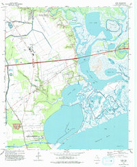 1993 Cove1993 Print · USGSThe coastal wetlands and bayous of Chambers County are captured in the early nineties as industry and nature meet near the bay. Trace local heritage and infrastructure through landmarks like the Winfree Cemetery, Barbers Hill Schools, and the Trinity Bay Oil Field.
 - 1993 Map of Morgans Point, 1994 Print
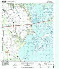
 1993 Morgans Point1994 Print · USGSThe industrial Texas coast around Baytown and Morgans Point comes alive in the early nineties. Researchers can trace neighborhood development near Lee College, find the Hill of Rest Cem, and study the extensive oil wells and ship channels that shaped the regional economy.
 - 1994 Map of Mont Belvieu
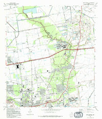 1994 Mont Belvieu1994 Print · USGSThe industrial and suburban landscape of Chambers and Harris Counties comes into focus during the early 1990s as oil production and urban growth intersect. Researchers can trace the layout of Mont Belvieu and Baytown, finding specific landmarks like the Jergins Oil Field, Busch Cem, and Stallworth Stadium.
 - 1994 Map of Umbrella Point
 1994 Umbrella Point1994 Print · USGSThe Texas coastline near Baytown comes alive in the 1990s as the energy industry and local history intersect along Trinity Bay. Genealogists and researchers can locate family sites like Barrow Cem and Fisher Cem or trace the Trinity Bay Oil Field.
 - 1995 Map of Highlands, 1998 Print
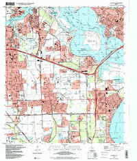
 1995 Highlands1998 Print · USGSThe industrial and historical heart of the Texas Gulf Coast comes into focus in the mid-nineties as the suburbs of Houston expand. Researchers can locate family landmarks like San Jacinto Cem, the iconic San Jacinto Monument, and schools such as Harlem Sch.
 - 1995 Map of La Porte, 1999 Print
 1995 La Porte1999 Print · USGSUpper Galveston Bay and the industrial heart of the Texas coast are detailed in this mid-1990s survey. Genealogists and local historians can trace the development of La Porte and Morgans Point alongside the San Jacinto Monument and Wooster Cem.
 - 1995 Map of Morgans Point, 1999 Print
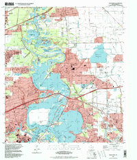
 1995 Morgans Point1999 Print · USGSBaytown and the surrounding coastal reaches of Galveston Bay are shown here during the mid-nineties as the region’s industrial and civic footprint matured. Researchers can trace neighborhood development near Lee College or locate landmarks like Morgans Point and Hill of Rest Cem.
 - 1995 Map of Cove, 2000 Print
 1995 Cove2000 Print · USGSThe Trinity River delta and Chambers County coast are captured here in the mid-nineties, showing a landscape of oil fields and winding bayous. Genealogists can trace family sites at Winfree Cemetery and St Emily Ch or locate the old Lost Cem.
End of results
Showing maps 1-9 of 9
Top cities near Baytown
- Houston historical maps
- Pasadena historical maps
- League City historical maps
- Channelview historical maps
- Texas City historical maps
- Friendswood historical maps
See more
Top neighborhoods of Baytown
- Pelly historical maps
- Wooster historical maps
- Brownwood historical maps
- Country Club Oaks historical maps
- Goose Creek Reserve historical maps
- Rolling Creek Estates historical maps
Frequently asked questions
- What are the different types of historical maps available for Baytown?
- What is the oldest map of Baytown?
- Where can I purchase historical maps of Baytown for my home or office?
- Where can I download high-res historical maps of Baytown?
- Are there historical topographic maps available for Baytown?
- Is there historical aerial imagery available for Baytown?
- Where are historical maps of Baytown sourced from?